
 Login
Login Register
 Submit a Paper
 Propose a Special lssue
 Open Access
REVIEW
A Comprehensive Review on Integrated Sensing, Communication, and Computing in Internet of Vehicles through Unmanned Aerial Vehicle: Recent Advances, Key Technologies, and Future Directions
1 School of Electronic and Information Engineering, Chongqing Sanxia University of Science and Technology, Chongqing, China
2 School of Automation, Chongqing University of Posts and Telecommunications, Chongqing, China
3 Department of Artificial Intelligence Foundations and Applications, Chongqing Changan Science and Technology, Chongqing, China
4 Training Center, State Grid Chongqing Electric Power Company, Chongqing, China
5 Department of Computer Science, Brunel University London, Uxbridge, Middlesex, UK
* Corresponding Author: Chao He. Email:
(This article belongs to the Special Issue: Advanced Technologies and Intelligent Applications for Autonomous Vehicles)
Computers, Materials & Continua 2026, 89(2), 5 https://doi.org/10.32604/cmc.2026.085383
Received 10 May 2026; Accepted 10 July 2026; Issue published 15 September 2026
 View Full Text
 Download PDF
Abstract
With the rapid development of fifth generation (5G), 5G-Advanced, edge computing, and early sixth generation (6G) technologies, the Internet of Vehicles (IoV) is evolving toward highly connected, intelligent, and delay-sensitive transportation services. Nevertheless, ground infrastructure still faces coverage holes, blockage, overloaded roadside units (RSUs), limited backhaul, and weak service continuity in urban canyons, crowded intersections, long highway segments, rural roads, and emergency areas. Unmanned aerial vehicles (UAVs) can provide flexible aerial relay, mobile sensing, temporary coverage, and lightweight edge computing support for these scenarios. This survey reviews UAV-assisted IoV from an integrated sensing, communication, and computing (ISCC) perspective. It first summarizes representative air-ground network architectures, including multi-UAV collaboration, vehicle-road-cloud collaborative edge computing, blockchain-supported edge intelligence, ISCC-oriented networking, low-altitude digital twins, and low Earth orbit (LEO) satellite-assisted networking. It then analyzes key technologies, including task offloading, dynamic resource allocation, low-latency and 6G-enabled communication, UAV endurance optimization, security and privacy protection, and intelligent algorithm-digital twin integration. Different from descriptive summaries, this review emphasizes the coupling among sensing quality, communication reliability, computing latency, information freshness, energy consumption, and deployment feasibility. Typical application scenarios, simulation tools, datasets, practical constraints, and open research challenges are also discussed. The review shows that UAVs should be regarded as complementary aerial nodes rather than replacements for RSUs and cellular base stations. Future UAV-assisted IoV systems require cross-layer ISCC design, low-complexity artificial intelligence (AI), reliable backhaul, regulation-aware deployment, and trustworthy data management.Keywords
The Internet of Vehicles (IoV) is becoming an important foundation for intelligent transportation, cooperative perception, autonomous driving, traffic management, and emergency response. With the deployment of fifth generation (5G) networks and the early development of sixth generation (6G) technologies, vehicular services are expected to support low latency, high reliability, high mobility, and massive data exchange. However, the performance of ground vehicular networks is still limited by blocked urban roads, dense intersections, tunnels, long highway segments, rural areas, and post-disaster regions. In these scenarios, roadside units (RSUs) or cellular base stations may be overloaded, unavailable, or unable to provide stable line-of-sight (LoS) links. Meanwhile, vehicles generate heterogeneous sensing, control, and computation tasks, which require timely processing and reliable transmission.
Unmanned aerial vehicles (UAVs) provide a flexible way to complement ground infrastructure. A UAV can be rapidly deployed to a target road segment, adjust its three-dimensional position, establish temporary air-ground links, collect sensing information, relay packets, cache data, and execute lightweight edge computing tasks. Therefore, UAV-assisted IoV is suitable for urban canyons, highway platoons, rural roads, traffic accidents, emergency rescue, and temporary traffic peaks. Nevertheless, UAV deployment is not automatically beneficial. UAVs are constrained by limited battery capacity, propulsion energy consumption, payload weight, airspace regulation, unstable handover, wireless interference, and privacy risks. A UAV that improves communication coverage may also increase scheduling complexity, energy consumption, and security exposure.
Studies on UAV-assisted vehicular communication, mobile edge computing (MEC), task offloading, resource allocation, blockchain-based trust, digital twins, and integrated sensing, communication, and computing (ISCC) have grown rapidly in recent years. A limitation in much of this literature is that these topics are usually examined one by one. In road environments, this separation is difficult to maintain. The flight path of a UAV affects the air-ground channel, the visible road area, the handover frequency, the computing burden placed on the aerial node, and the remaining battery at the same time. A task offloading decision may shorten local execution delay, but it can also add radio traffic, backhaul load, and privacy exposure. For this reason, UAV-assisted Internet of Vehicles (IoV) is better discussed under an integrated sensing, communication, and computing (ISCC) view than under a single communication or computing model.
The review is organized around that view. It examines representative architectures and technologies, but the discussion is not limited to listing prior studies. Where possible, the survey points out the assumptions behind the reported results, the scenarios in which a method is likely to work, the metrics used for evaluation, and the restrictions that may appear in deployment.
The main contribution of this review is to place UAV-assisted IoV under a system-level framework that links sensing, communication, computing, mobility, energy consumption, and deployment constraints. The paper reviews representative air-ground architectures, including multi-UAV collaboration, vehicle-road-cloud collaborative edge computing, blockchain-supported edge intelligence, low-altitude digital twins, and low Earth orbit (LEO) satellite-assisted networking. These architectures are compared in terms of coverage, computing support, trust, scalability, and sensing-communication-computing coordination. The technical discussion then turns to task offloading, dynamic resource allocation, low-latency and 6G-enabled communication, UAV endurance, security and privacy, and intelligent algorithm-digital twin integration. Rather than treating these topics as independent modules, the review relates them to latency, energy consumption, Age of Information (AoI), computing cost, and sensing quality. The discussion is further connected with urban roads, highways, and rural roads, where the requirements for coverage, mobility support, reliability, and deployment cost differ considerably. The last part of the paper summarizes open issues related to cross-layer design, real-scenario adaptation, service continuity, UAV battery limits, backhaul constraints, Doppler effects, channel state information (CSI) acquisition, synchronization overhead, airspace regulation, and trustworthy data management.
1.1 Review Methodology and Literature Classification
The literature search combined database queries with backward and forward checking of relevant references. The search was conducted in IEEE Xplore, ScienceDirect, SpringerLink, ACM Digital Library, Web of Science, Scopus, MDPI, and related publisher platforms. The keywords were combined around three groups: the application scenario, such as “UAV-assisted Internet of Vehicles” and “UAV-assisted IoV”; the integration theme, such as “integrated sensing, communication, and computing”, “integrated sensing, communication and computing”, “vehicular edge computing”, and “task offloading”; and the enabling technologies, such as “resource allocation”, “multi-UAV collaboration”, “digital twin vehicular networks”, “blockchain-enabled IoV”, “reconfigurable intelligent surface (RIS)-assisted vehicular communication”, “terahertz (THz) vehicular communication”, “cell-free massive multiple-input multiple-output (MIMO)”, “semantic communication”, and “6G vehicular networks”.
After duplicate removal, the papers were read with attention to their roles in the review: architecture description, system modelling, optimization objective, algorithm design, evaluation metric, scenario setting, simulation tool, dataset, or deployment discussion. Recent studies were emphasized because UAV-assisted IoV is closely related to 5G-Advanced and 6G-oriented networks. Earlier works were also retained when they introduced basic models, representative methods, simulators, or real trajectory datasets that are still used in vehicular networking studies.
The material was then organized into six groups: network architecture, task offloading and computation cooperation, resource allocation and trajectory optimization, low-latency and 6G-enabled communication, UAV energy management, and security/privacy protection. Digital twins and intelligent algorithms are discussed together with these groups when they contribute to modelling, prediction, or adaptive decision-making. This organization is used to keep the survey connected to the UAV-assisted IoV scenario rather than to present the topics as isolated technical lists.
1.2 Positioning Relative to Existing Surveys
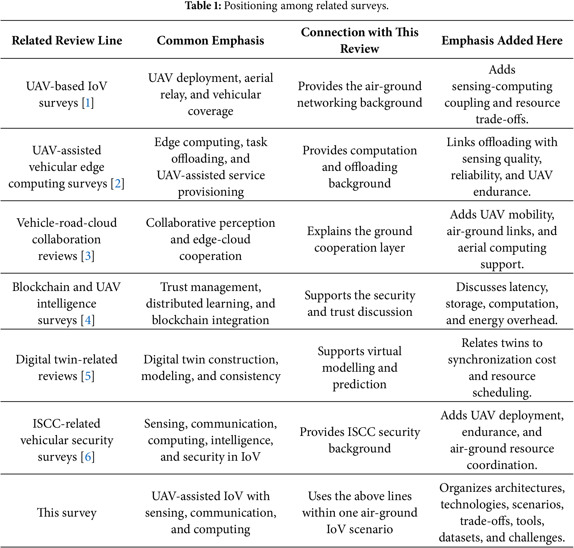
Related surveys provide useful entry points into UAV-based IoV [1], UAV-assisted vehicular edge computing [2], vehicle-road-cloud collaboration [3], blockchain-assisted UAV applications [4], digital twins [5], and ISCC-related vehicular security [6]. This review does not repeat these topics as separate tracks. Instead, it uses UAV-assisted IoV as the common scenario and connects air-ground networking with sensing, computing, resource scheduling, energy constraints, intelligence, and deployment feasibility. Table 1 positions the scope of this review alongside related survey topics.
The remainder of this paper is organized as follows. Section 2 reviews representative network architectures for UAV-assisted IoV, including multi-UAV collaboration, vehicle-road-cloud collaborative edge computing, blockchain-empowered edge intelligence, ISCC-oriented architecture, low-altitude digital twin networks, and LEO satellite-assisted intelligent networks. Section 3 discusses key technologies, including task offloading, dynamic resource allocation, low-latency communication, UAV energy management, security and privacy protection, and intelligent algorithm-digital twin integration. Section 4 summarizes typical application scenarios, including urban roads, highways, and rural roads. Section 5 discusses open challenges and research prospects from the perspectives of cross-layer collaboration, real-scenario adaptation, practical deployment, security, trustworthiness, and continuous operation. Section 6 concludes the paper.
This section reviews representative architectures for UAV-assisted IoV. Here, the architecture is not treated as a coverage diagram only. A deployable system also has to support sensing, computing, mobility management, trust management, energy control, and service continuity. Multi-UAV collaboration is mainly used for flexible coverage and cooperative sensing. Vehicle-road-cloud collaboration provides a layered computing structure. Blockchain-supported edge intelligence is used for trust and access control. ISCC-oriented networking links sensing, communication, and computing decisions. Low-altitude digital twins offer virtual modelling and short-term prediction, while LEO satellite-assisted networking is more relevant when terrestrial backhaul is weak.
These components overlap in operation. Moving a UAV may improve the line-of-sight link, but it may also increase propulsion energy. A stronger authentication process may reduce security risk, while adding delay and computation overhead. A wider sensing range may improve road awareness, but the resulting data must still be transmitted and processed in time. The architectural problem is therefore one of coordination among communication, computation, sensing, energy, and security under vehicular mobility.
Fig. 1 compares representative UAV-assisted IoV network architectures in terms of coverage flexibility, computing support, trust mechanism, ISCC capability, and network extensibility.
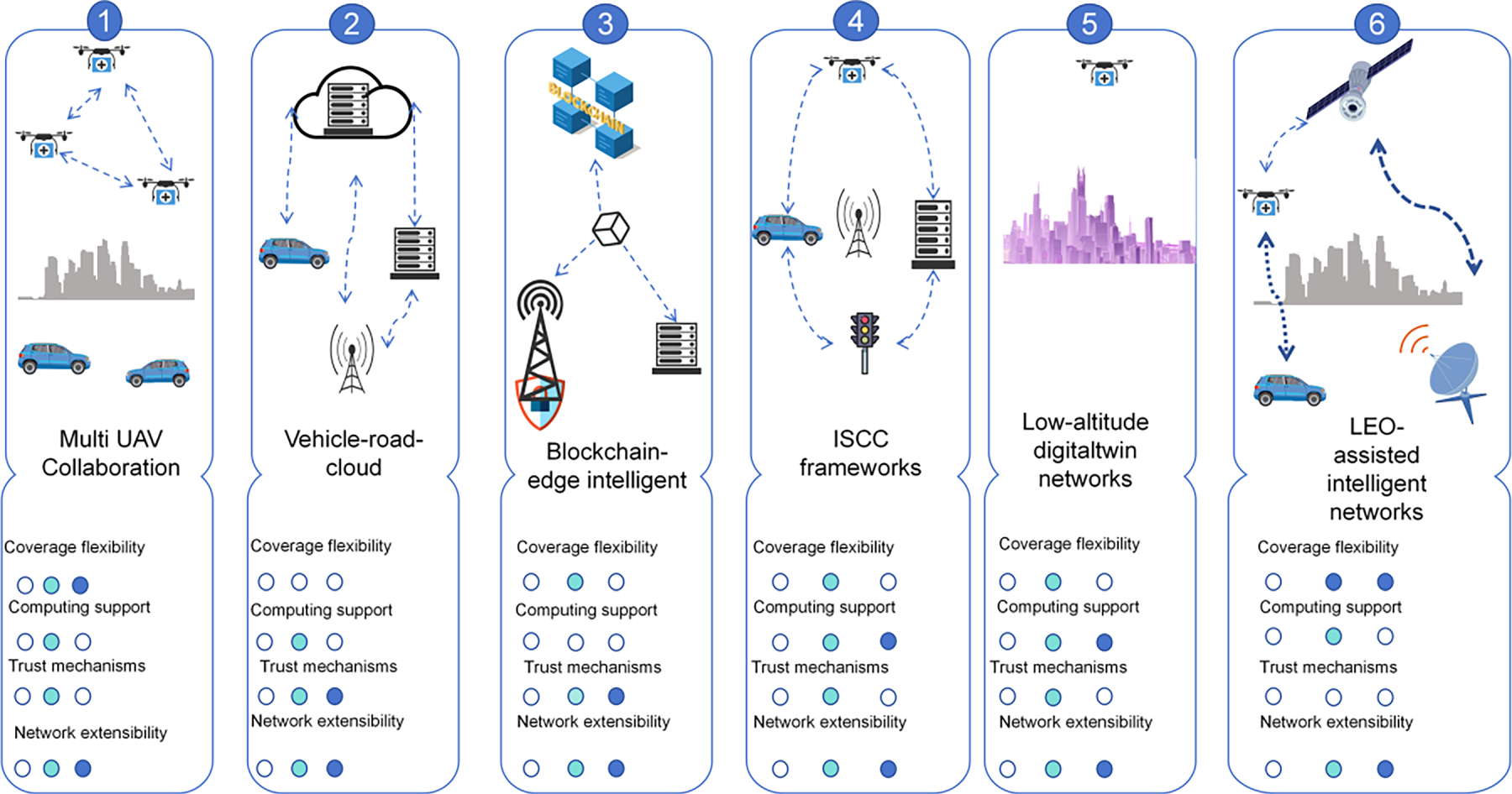
Figure 1: Comparison of representative UAV-assisted IoV network architectures.
A single UAV is often insufficient for busy and time-varying road environments. In high-speed traffic, accident-induced hotspots, or temporarily overloaded areas, one aerial node may not cover the entire service region or process all tasks within their deadlines. Ground RSUs may also be blocked, overloaded, or too far from vehicles. Multi-UAV collaboration therefore divides coverage, spectrum access, sensing tasks, relay functions, and computing workloads among several aerial nodes.
Multi-UAV collaboration can be centralized, distributed, or hybrid depending on service density and control requirements. UAV swarms can form aerial self-organizing networks through air-to-air (A2A) and air-to-ground (A2G) links, exchanging local observations, model updates, and routing information with vehicles, RSUs, and other UAVs. The shared situation map may include road condition, vehicle density, interference, blockage, and wind state. Service tasks can then be divided into communication relaying, cooperative perception, and edge computing according to task granularity and resource heterogeneity. When traffic load increases or link quality degrades, the swarm can adjust its topology, select new access or forwarding paths, and migrate computing tasks.
Recent studies show that multi-UAV assistance can reduce routing overhead, improve packet delivery, and reduce end-to-end delay under heavy traffic [7]. Delay analysis of UAV-assisted cellular vehicle-to-everything (C-V2X) further indicates that aerial relaying combined with edge collaboration can reduce queuing and scheduling bottlenecks [8]. Other studies formulate multi-UAV cooperation as secure multi-agent resource allocation [9], intention-aware cooperative perception [10], multi-objective MEC optimization [11], source-correlation-aware communication [12], multi-UAV asset edge computing [13], and decentralized UAV resource management [14].
The main conclusion is that increasing the number of UAVs does not automatically improve service quality. Path planning, access links, spectrum allocation, computing load, and energy consumption must be coordinated. If inter-UAV signalling and control overhead become too high, the gain of the swarm may be offset. Multi-UAV collaboration should therefore be designed as a resource-coordination problem rather than merely as a coverage-extension scheme.
2.2 Vehicle–Road–Cloud Collaborative Edge Computing
Cloud-centred IoV is simple in architecture but cannot always meet the delay and reliability requirements of vehicular services. When many vehicles access the network simultaneously, remote cloud processing may introduce long response time and heavy backhaul load. Privacy rules may also differ across administrative domains, and collaborative perception may still suffer from occlusion or missed detection. In addition, many vehicular applications contain dependent subtasks. If all tasks are sent to a single RSU or cloud server, the node may become overloaded and task dependencies may not be properly scheduled [3].
Vehicle–road–cloud collaborative edge computing brings computation closer to the data source while preserving the cloud for global coordination and long-term model training. Vehicles can perform local preprocessing and lightweight inference, RSUs can provide nearby edge services and coordination, and the cloud can maintain global models and long-term policies. This layered design reduces unnecessary backhaul transmission and allows tasks with different dependency, latency, and resource requirements to use different computing tiers.
Dependency-aware and resource-aware offloading has therefore become an important research direction. Cooperative computation and dependency-aware task offloading can model vehicular applications as directed acyclic graphs (DAGs) and use learning-based methods such as deep deterministic policy gradient (DDPG) to solve continuous offloading decisions under task-dependency constraints [15]. Vehicle-to-infrastructure (V2I)/vehicle-to-vehicle (V2V) cooperative offloading and resource allocation can distribute computing load among vehicles and infrastructure nodes, reducing processing delay and easing RSU overload in dense traffic [16]. More recent studies further consider RSU-RSU load balancing [17], mobility-aware digital twins [18], resource-aware multi-task offloading [19], and dependency-aware online task offloading [20] to improve service robustness in highly dynamic vehicular environments.
The key implication is that the cloud should not be the default execution place for all complex vehicular functions. Task dependency, RSU load, link quality, vehicle mobility, and privacy requirements may all change the suitable execution location. Vehicle–road–cloud cooperation provides a hierarchical computing structure, but its benefit depends on timely state collection, efficient task decomposition, and low-overhead coordination across layers.
2.3 Blockchain-Empowered Edge Intelligence
Blockchain is considered in this survey as a support layer rather than the core of the ISCC framework. Its value lies in identity authentication, trusted data sharing, access control, and service auditing among vehicles, UAVs, RSUs, and edge nodes. These functions are important because UAV-assisted IoV may involve short-lived air-ground contacts, cross-domain service providers, and heterogeneous participants that do not always share the same trust authority. In such cases, a distributed ledger or smart-contract mechanism can record service transactions, reputation updates, model aggregation results, and resource-allocation agreements.
The benefit of blockchain should be interpreted together with its cost. Consensus procedures, ledger storage, contract execution, and key management introduce additional latency, computation, and energy consumption. These costs are especially relevant when UAVs act as relays or lightweight edge nodes with limited battery and processing capability. Therefore, blockchain is more suitable for tasks that require auditable coordination, multi-party trust, or service settlement than for every low-latency safety message. Federated-learning and blockchain integration provides one trust-management route for UAV applications [4]. Blockchain-enabled digital-twin vehicular edge networks show how task offloading and edge cooperation can be recorded and coordinated [21]. Secure UAV-assisted V2X offloading frameworks further connect blockchain with lifecycle protection [22]. Blockchain-enabled V2X offloading can also support multi-object computing decisions [23], while dual-game resource-allocation designs illustrate how service agreements may be formed under UAV-assisted MEC constraints [24].
For UAV-assisted ISCC-IoV, blockchain should be integrated selectively. It can strengthen the trust layer for shared sensing data, task transactions, and distributed learning, but it cannot replace low-latency communication, lightweight authentication, or privacy-preserving data processing. The key design issue is to decide which operations need ledger-level accountability and which operations should remain at the edge or physical layer to avoid unnecessary control overhead.
2.4 Integrated Sensing, Communication, and Computing (ISCC)
Integrated Sensing, Communication, and Computing (ISCC) is the central design perspective of UAV-assisted IoV. In conventional vehicular systems, sensing, communication, and computing are often modelled as separate functions: sensors collect road information, wireless links transmit messages, and edge or cloud servers process tasks. This separation becomes less appropriate once UAVs are introduced into the vehicular network. A UAV may simultaneously observe a road segment, relay packets, provide temporary coverage, execute lightweight computation, and adjust its three-dimensional trajectory under a strict energy budget.
The interaction among sensing, communication, and computing is not a simple parallel integration. Sensing provides environmental awareness, including vehicle density, road obstacles, channel blockage, traffic flow, and mobility patterns. These results can support beam tracking, handover prediction, UAV trajectory adjustment, resource scheduling, and proactive task offloading. However, sensing information is useful only when it can be transmitted and processed before it becomes outdated. If the communication link is blocked or the edge server is congested, a high-accuracy sensing result may lose its operational value.
Communication determines whether sensing data, extracted features, computation tasks, and control decisions can be delivered within the required delay bound. A reliable air-ground link can improve offloading success and reduce transmission delay, but it may require higher transmit power, more spectrum resources, or a UAV position that is not optimal for road sensing. Computing further affects the timeliness of ISCC services. Edge inference can support object detection, traffic prediction, cooperative perception, and anomaly detection, but queueing delay and model-execution delay may increase the Age of Information (AoI). Therefore, the key design issue is not to maximize sensing accuracy, communication rate, or computing capacity separately, but to balance them under UAV energy, mobility, spectrum, and edge-resource constraints.
The resource conflict can be illustrated by several common cases. Increasing the sensing frequency improves situational awareness but generates more data traffic and computing load. Increasing transmit power improves link reliability but drains the UAV battery and may increase interference. Moving the UAV closer to vehicles can shorten the communication distance but may reduce sensing coverage or increase propulsion energy. Onboard processing can reduce backhaul traffic but consumes processor energy and may compete with flight-control and sensing tasks. These trade-offs explain why throughput or average latency alone is insufficient for evaluating UAV-assisted ISCC-IoV.
A simplified objective can be written as
where
This expression is intended as a compact description of the ISCC trade-off rather than a universal optimization model. Safety warnings usually place stronger weight on latency and information freshness. Long-term traffic monitoring may emphasize flight duration and sensing coverage. Cooperative perception may treat sensing quality and link reliability as hard constraints. The appropriate weights and constraints depend on service type, vehicle mobility, UAV battery state, channel condition, and edge-computing capacity.
Recent work on ISCC in vehicular and aerial networks can be viewed from two related aspects. In the IoV setting, Li et al. reviewed the opportunities and challenges of integrated sensing, communication, and computation, and pointed out that sensing-data collection, wireless delivery, edge processing, and resource scheduling should be handled within the same vehicular service process [25]. Zhao et al. developed an IoV-oriented ISCC system and examined how sensing, computation, and communication resources are assigned under vehicular service requirements [26]. Yang et al. considered the same type of problem in a dynamic vehicular network, where radio resources, computing resources, and service demands are adjusted with vehicle mobility and changing network states [27]. In UAV-assisted systems, this coupling is more direct because a change in UAV position may alter the sensing view, the air-ground channel, the transmission distance, and the available computation time at the same time. Xie et al. analysed joint sensing, communication, and computation in UAV-assisted systems, where trajectory design, transmit power, sensing decisions, and task scheduling are optimized together [28]. Liu et al. studied an air-ground collaborative ISCC system and included UAV mobility, sensing tasks, communication resources, computing load, and energy constraints in the same scheduling problem [29]. Related work on collaborative sensing-aware offloading in IoV also shows that sensing, transmission, and computing form a continuous service process rather than three isolated operations [30]. Earlier UAV-assisted studies for mobile vehicles and Internet of Things (IoT) environments reach a similar conclusion for trajectory planning, task scheduling, and radio-resource control in aerial networks [31]. UAV-enabled ISCC studies in IoT networks provide additional evidence that the sensing objective, computing load, and flight trajectory should be considered together [32]. For UAV-assisted IoV, these findings mean that vehicle mobility, service deadlines, air-ground channel variation, edge workload, and UAV propulsion energy should be modelled in the same design process.
Several assumptions in the literature still require caution. Vehicle positions, CSI, task queues, and UAV battery states are often assumed to be accurately known. In practice, these states may be delayed or incomplete because of GPS errors, blockage, feedback overhead, and handover interruption. The complexity of joint optimization also grows rapidly when multiple UAVs, many vehicles, dynamic tasks, and coupled sensing-communication resources are included. Practical ISCC design therefore requires low-complexity, adaptive, and robust algorithms rather than only offline optimal solutions.
2.5 Low-Altitude Digital Twin Networks
In ISCC-oriented UAV-assisted IoV, a low-altitude digital twin can provide virtual modelling, short-term state prediction, risk evaluation, and decision verification before control actions are applied to the physical system. A twin may estimate traffic density, UAV coverage holes, edge-server load, handover risk, and air-ground link quality. These estimates can then support sensing scheduling, communication-resource allocation, computation offloading, and trajectory control. The reliability of such decisions depends on synchronization accuracy, data freshness, and model consistency. A slowly updated or biased twin may be useful for replay analysis, but it is not reliable for real-time vehicular control.
Digital twins are not cost-free virtual services. In vehicular edge computing networks, twin maintenance and task processing may compete for the same edge resources [33]. This issue is directly relevant to UAV-assisted IoV. When UAVs, RSUs, or edge servers maintain twin states while processing offloaded tasks, twin updating introduces additional computing load, communication traffic, and synchronization delay. Therefore, digital-twin functions should be evaluated together with edge-resource allocation, queueing delay, and service deadlines.
A low-altitude digital twin network can provide a computable representation of urban airspace, roads, communication facilities, UAVs, vehicles, and RSUs. Such a model can integrate three-dimensional geography, traffic flow, airspace status, and communication-link conditions on a shared time basis. Physics-based models and data-driven models can be combined to estimate operational risk and resource availability. At the decision level, path planning, conflict resolution, airspace-capacity assessment, link scheduling, caching, and offloading can be formulated as rolling optimization problems updated by online feedback. In this sense, the digital twin is an operational support tool rather than a visual display layer.
Recent studies on low-altitude and UAV-oriented digital twins provide several useful mechanisms. Hybrid modelling and evidence fusion can improve the fidelity of twin construction for advanced air mobility [5]. Grid-based or voxelized twins can divide urban airspace into smaller regions, supporting safety quantification, path planning, and capacity assessment within a common spatial model [34]. Stream-processing protocols such as Message Queuing Telemetry Transport (MQTT) can aggregate state data and trigger event-driven updates in high-concurrency environments [35]. Operational twins have also been combined with transfer learning and object detection to improve obstacle avoidance and situational awareness under bad weather or occlusion [36].
As the model scope expands, the digital twin becomes a coordination environment for sensing, communication, and computing decisions. Low-altitude twins can be connected with Space-Air-Ground Integrated Networks (SAGINs), where satellite, aerial, and terrestrial resources are represented in the same virtual layer to improve resilience in large-scale or disconnected missions [37]. For UAV-assisted IoV, digital twins have also been used as the decision layer for resource allocation, where virtual states of vehicles, UAVs, wireless links, and task queues are updated to guide scheduling under mobility [38]. Their effectiveness still depends on reliable traffic data, UAV trajectory records, communication traces, and timely synchronization. For low-altitude IoV, the twin should therefore be treated as a decision-support environment whose accuracy and update cost must be balanced against the latency requirements of vehicular services.
2.6 Low Earth Orbit Satellite-Assisted Intelligent Networks
Low-altitude UAV services require stable wide-area connectivity, especially where terrestrial coverage is weak. Terrestrial 5G can support many urban services, but coverage becomes less reliable in remote areas, cross-domain missions, and emergency scenarios. In these cases, Low Earth Orbit (LEO) satellites can extend communication coverage and provide additional backhaul support.
LEO-assisted architecture offers several advantages for UAV-assisted IoV. Satellite constellations can increase coverage range and improve service continuity when terrestrial infrastructure is sparse or damaged. Compared with high-altitude satellite systems, LEO satellites have shorter propagation distance and lower delay. Redundant satellite links can also reduce the need for dense ground infrastructure in emergency and rapid-deployment missions.
At the architectural level, LEO constellations can extend conventional air-ground communication into a space-air-ground cooperative network. Satellite links can provide wide-area backhaul, while UAVs act as mobile access points or relays together with ground stations. Such integration can improve service continuity across land, sea, and air scenarios. Its deployment is still difficult because LEO, aerial, and terrestrial segments have different channel conditions, propagation delays, resource allocation mechanisms, and coordination requirements.
In LEO-assisted UAV networks, the bottleneck is often not only access coverage but also backhaul coordination. Access-backhaul integration can jointly design the UAV access link and LEO backhaul, forming a two-hop or multi-layer transmission structure for low-altitude networks [39]. Joint access/backhaul resource allocation treats satellites as active network resources rather than passive connectivity support [40]. Under bandwidth-utilization and fairness requirements, UAV energy constraints should also be included in resource allocation to extend service time [41]. Wireless backhaul selection further needs to consider remaining service time and link capacity to maintain service continuity and network efficiency [42]. These methods are more suitable for remote areas and emergency services than for short urban trips, where satellite handover and backhaul operation may increase cost.
LEO support is most valuable when terrestrial backhaul is weak or when the service area exceeds the range of UAV relays. It should not be regarded as a general replacement for ground networks. Satellites, UAVs, and ground stations operate at different distances and under different line-of-sight, resource, and control-delay conditions. A key issue is how to coordinate these layers without allowing handover and backhaul-scheduling overhead to offset the coverage gain.
3 Key Technologies for UAV-Assisted IoV
Once the architecture is fixed, the system still has to decide how to schedule communication, sensing, computing, energy, and security resources under changing traffic. UAVs improve coverage and may offer aerial computing support, but their gains are limited by battery life, air-ground channel variation, payload capacity, interference, and backhaul availability. The techniques in this section are therefore closely related. Task offloading changes wireless load and edge computing demand; resource allocation changes latency and energy use; low-latency communication depends on mobility and CSI acquisition; and security mechanisms add computation and signalling overhead. The following review discusses not only reported gains, but also assumptions, scalability, complexity, and practical applicability. Fig. 2 summarizes the main technological domains in UAV-assisted IoV.
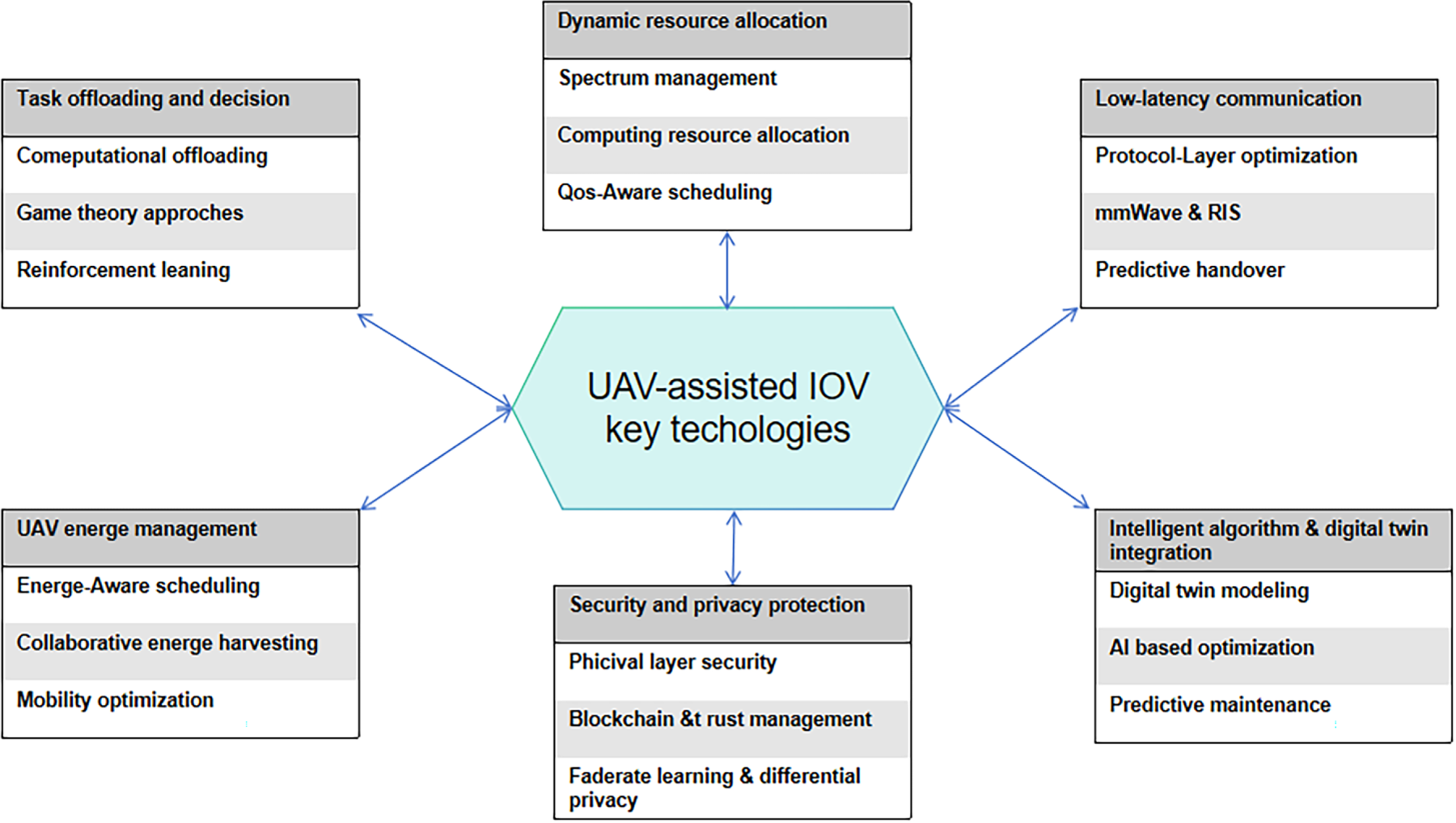
Figure 2: Key technological domains of UAV-assisted IoV.
In conventional IoV, computation offloading is usually supported by fixed RSUs, gNBs, and MEC servers. This layout works well in areas with stable infrastructure, but it becomes less effective in urban canyons, rural roads, congestion zones, or emergency areas where ground nodes are blocked, overloaded, or unavailable. UAVs can extend coverage through mobility and may also provide lightweight computing support. These benefits come with new constraints, including limited battery capacity, unstable air-ground links, changing UAV positions, and shared wireless-computing resources. UAV-assisted task offloading therefore requires joint consideration of task partitioning, link selection, UAV placement, edge-resource allocation, and energy consumption.
The main performance concerns include latency, energy consumption, AoI, reliability, task-completion ratio, and resource fairness. Across the reviewed studies, the practical question is where a task should be executed, when it should be offloaded, and which link should return the result. Three modelling approaches are useful for organizing this discussion: weighted-sum modelling, Pareto frontier analysis, and context-aware offloading.
A weighted-sum model combines several objectives into a single scalar function. Delay, energy, freshness, computing cost, and sometimes fairness are assigned weights so that an optimizer or learning agent can operate on one reward. This formulation is compact, but its result depends strongly on the selected weights. In road-safety services, a delay violation and a small energy increase should not be treated as equivalent merely because both appear as weighted terms. The weights should therefore reflect service requirements rather than only being tuned to improve simulation curves. A general form is
where
Weighted-sum formulations have been used to jointly optimize offloading, subband assignment, power control, and computing-resource allocation in MEC-enabled aerial-terrestrial vehicular networks [43]. Other work includes AoI, energy consumption, and computing rental price in a linear weighted objective and solves the problem with soft actor-critic scheduling [44]. DRL-based weighted cost functions have also been used to analyse the delay-energy trade-off [45]. These results are useful, but their conclusions may change when traffic density, UAV battery state, or channel condition changes. Weight-sensitivity tests, tail-delay results, and failed cases should therefore be reported together with average performance.
3.1.2 Pareto Frontier Analysis
Pareto frontier analysis makes objective conflicts explicit rather than hiding them in a single reward. It identifies non-dominated solutions, where improving one objective necessarily degrades at least one other objective. This approach is useful when latency, energy, coverage, and resource utilization do not have a fixed priority order. A solution
where
Pareto-based studies have been used for vehicular edge task offloading [46], multi-UAV-assisted MEC trajectory optimization [47], and edge-UAV deployment optimization [48]. Their advantage is that they reveal the trade-off surface, but they still require a service-specific operating point. A frontier with many non-dominated points may be mathematically complete but difficult to use in real-time control. For vehicular services, the most useful Pareto result should provide a knee point, a selection rule, or a clear explanation of the infeasible region.
3.1.3 Context-Aware Offloading
Context-aware offloading treats task placement as a control problem under changing conditions. Decisions may depend on vehicle position and speed, traffic congestion, link quality, UAV battery level, edge-server queue length, backhaul load, and service-level requirements. The main challenge is that context collection is itself costly. Many evaluations assume that location, CSI, queue length, and battery state are accurately known at the beginning of each decision epoch. In practice, GPS drift, delayed channel reports, blockage, and handover gaps may make these states incomplete or outdated.
The reviewed methods differ mainly in the context variables included in the decision. Urban hotspot and street-canyon studies jointly model user mobility and coverage constraints to reduce latency and improve task-completion rate [49]. In UAV-assisted IoV, DRL-based task-offloading optimization can jointly adjust UAV trajectory, task placement, and radio/computing resources under limited UAV energy and time-varying vehicular demand [50]. A related computation-offloading model for UAV-assisted vehicular edge computing further emphasizes the coupling between trajectory control, server selection, and vehicular task dynamics [51]. DRL-game optimization [52], fuzzy decision-making [53], and UAV-assisted MEC offloading under bursty traffic [54] have also been studied to balance latency, energy consumption, inference accuracy, task success, and stability. These studies indicate that an offloading algorithm may lose its advantage if the required state information is delayed, incomplete, or expensive to obtain.
Fig. 3 illustrates a typical offloading decision framework for UAV-assisted IoV. Before a task is executed locally or offloaded to a UAV, RSU, edge server, or cloud server, the system must consider task size, available computing resources, network conditions, delay constraints, energy constraints, and the return path of the result. The figure therefore represents the connection among communication, computation, and mobility rather than a fixed offloading rule.
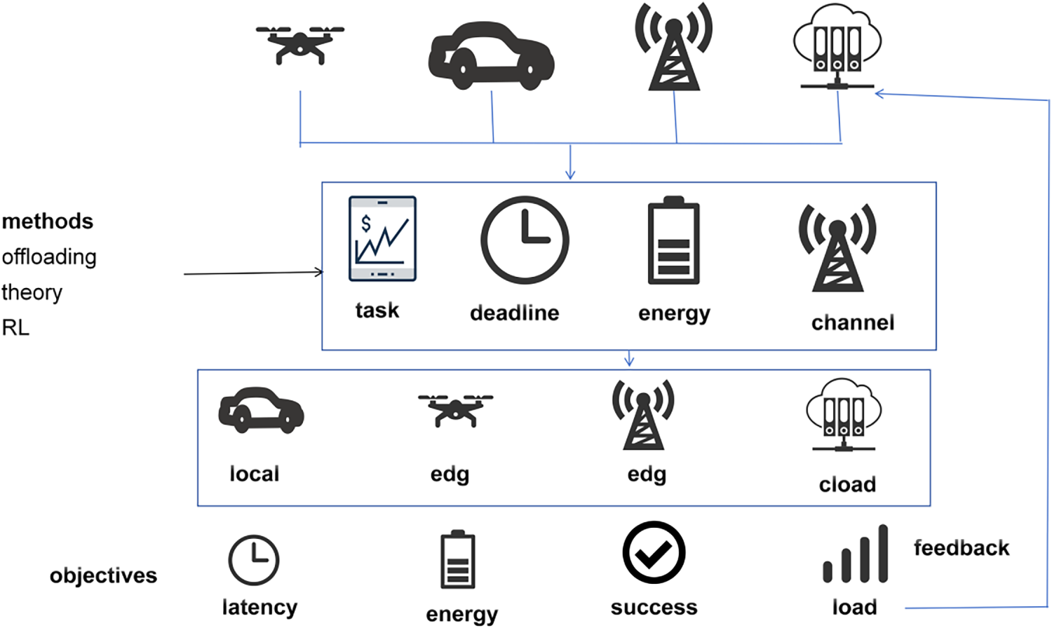
Figure 3: Offloading decision framework.
From a critical perspective, most task offloading models rely on assumptions that may not hold in real vehicular scenarios. Many methods assume that task size, vehicle trajectory, CSI, and edge-server load are available when the offloading decision is made. In practice, these states may be outdated because of high mobility, blockage, feedback delay, and handover. DRL-based offloading can adapt to dynamic environments, but it usually requires many training samples and may suffer from unstable convergence when vehicle density changes. Offloading to UAVs may reduce local computation delay but increase uplink transmission delay, interference, and UAV energy consumption. Therefore, offloading decisions should be evaluated by latency, energy, AoI, task success ratio, and UAV endurance rather than by computing delay alone.
Freshness-aware optimization has become important for IoV services. In C-V2X-enabled IoV, DRL has been used to jointly optimize AoI and energy consumption, showing that task scheduling should consider both information freshness and energy efficiency [55]. Although this study does not focus on UAV-assisted IoV, it supports the argument that freshness and energy should be analysed together in vehicular scheduling. When the idea is extended to UAV-assisted IoV, UAV trajectory, relay selection, aerial energy consumption, and air-ground channel variation should also be included.
3.2 Dynamic Resource Allocation
The value of UAVs in IoV lies in their ability to provide mobile coverage, relay support, sensing, and edge-computing assistance together with terrestrial infrastructure. Vehicle density changes over time, task arrivals are irregular, and air-ground channels depend on UAV position, blockage, and mobility. Resource allocation should therefore not be limited to bandwidth and CPU assignment. It should coordinate communication, computation, caching, backhaul, and energy resources among vehicles, UAVs, RSUs, and edge servers. A basic resource constraint for UAV
where
3.2.1 UAV Resource Pooling Techniques
UAV resource pooling treats multiple UAVs as a shared pool of communication, computation, storage, and sensing resources. It can reduce the risk that one UAV is overloaded while another remains underutilized, and it can support service migration when traffic hotspots move between coverage areas. However, pooling is not a free service. It requires state exchange, resource bookkeeping, task migration, and coordination among aerial nodes. If inter-UAV backhaul is weak or the traffic surge is short-lived, the overhead of pooling may exceed its benefit.
Existing studies implement different levels of pooling realism. UAV-mounted cloudlets have been organized as a shared computing ensemble for task offloading and inter-UAV cooperation [56]. Resource pricing and risk-aware user decisions have been studied when shared UAV-MEC servers provide uncertain resource availability [57]. Network slicing can virtualize and orchestrate communication and computation resources in UAV-assisted vehicular networks [58]. Cooperative task offloading in UAV swarms [59] and computing-power-pool designs [60] further show how dependent tasks can be handled through pooled aerial resources. These approaches require timely knowledge of pool status; otherwise, resource migration and slice management may become unstable in low-altitude vehicular environments.
3.2.2 Collaborative Resource Management between UAVs and Vehicles
Collaborative resource management integrates vehicle-side local computing, caching, and PC5-based sidelink communication with UAV-enabled mobile coverage, aerial edge computing, and multi-hop relaying. Vehicles may perform lightweight local inference and share cached data with nearby vehicles. UAVs can provide emergency coverage, aerial computing, and relay support. RSUs and edge servers can serve as nearby computation and backhaul nodes. The purpose is to distribute service demand among terminal, roadside, aerial, and cloud resources according to task urgency, resource availability, and mobility.
Recent work has shifted from simply adding an offloading helper to deciding which entity should be responsible for each part of the service. Mobility-aware resource allocation can combine vehicle-location prediction, offloading decisions, and multi-UAV coordination to improve task-processing stability [49]. Learning-based channel allocation and task offloading can jointly use vehicular local computation and UAV/edge-assisted execution under fluctuating traffic [61]. RSU-RSU load balancing [17], digital-twin-assisted allocation [62], and long-term UAV-RSU-vehicle cooperation [63] have also been studied to reduce delay and improve the latency-energy trade-off. These gains should be interpreted with care when the evaluation assumes predictable vehicle paths, stable task sizes, or low wireless contention. Under dense traffic, cooperation among vehicles, RSUs, and UAVs becomes difficult because routing, computing load, and channel access change simultaneously.
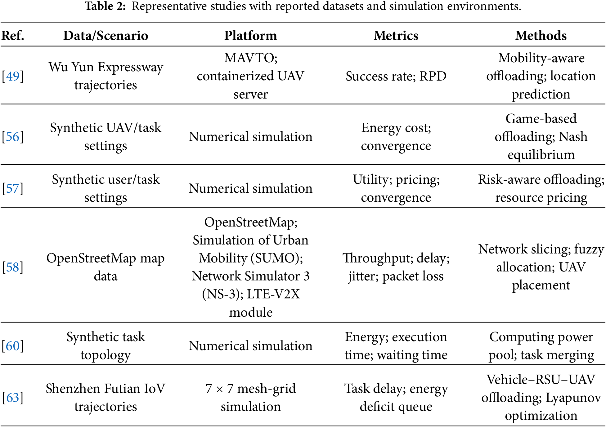
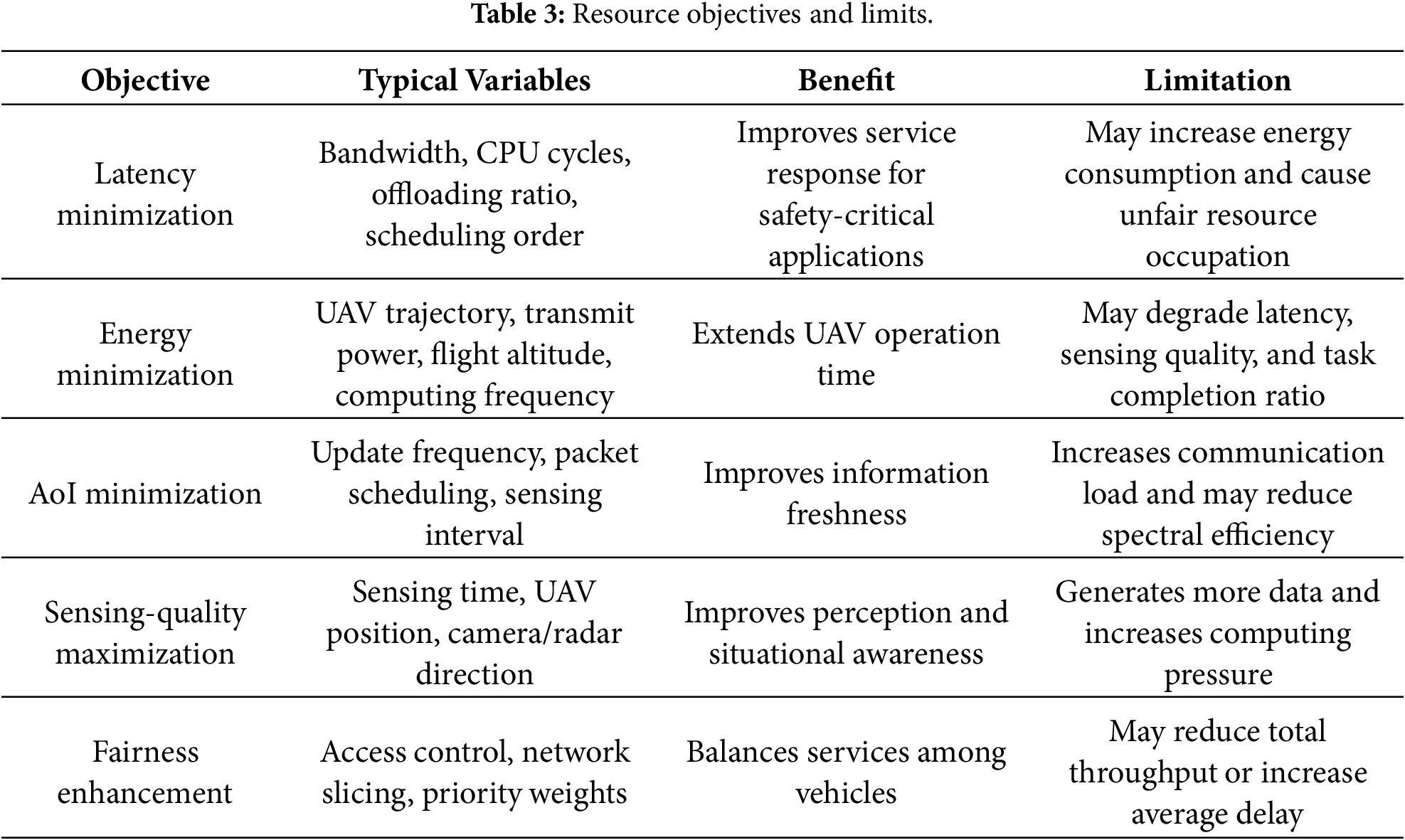
The reviewed studies do not use the same evaluation basis. Some papers report mobility simulators, traffic datasets, channel assumptions, and performance metrics in detail, whereas others mainly use simplified numerical settings. Table 2 is therefore used to record the evidence behind the reported results, so that the studies can be compared not only by algorithm type but also by the traffic model, data source, and evaluation indicators adopted. In the same resource-allocation context, Table 3 summarizes typical resource-allocation objectives and their limitations. The table shows that different objectives may conflict with each other. Minimizing latency often requires more bandwidth, higher transmission power, or more computing cycles, which may increase energy consumption. Minimizing AoI requires frequent status updates, but frequent updates may occupy wireless resources and increase interference. Therefore, resource allocation in UAV-assisted IoV should be formulated as a multi-objective and cross-layer problem.
3.3 Low-Latency and 6G-Enabled Communication Technologies
Low latency in UAV-assisted vehicular networks is broader than packet transmission time. Cooperative perception, emergency warning, remote driving, and task offloading require short end-to-end delay across access, transmission, queuing, execution, and handover. A common decomposition is
where
The following methods are grouped by the delay component they mainly reduce. The grouping is only a working classification, since in UAV-assisted IoV these delays often interact.
3.3.1 Protocol-Layer Optimization
Protocol-layer optimization reduces access and scheduling overhead without changing the radio hardware. 5G New Radio vehicle-to-everything (NR-V2X) sidelink scheduling over the PC5 interface is a typical starting point. By tuning medium access control parameters such as persistence probability and packet repetition, existing studies show the trade-off among collision probability, Age of Information (AoI), and latency in UAV-assisted relaying and access scenarios [64]. Multi-hop and relay-assisted cooperation target another source of delay, namely range limitation and link interruption. Sidelink relaying can extend coverage and help safety and cooperative perception messages arrive within their service deadlines. Cross-layer delay decomposition can separate access, queuing, scheduling, and handover delay, and then choose sidelink mode, redundancy, multipath transmission, or adaptive configuration [65].
Protocol optimization is useful when the bottleneck lies in access contention or control signalling. It is less effective when most delay comes from edge-server queues or backhaul congestion. Opportunistic UAV support has also been used to improve the timeliness of vehicular message delivery in platooning-oriented urban scenarios [66]. These results suggest that protocol tuning should be evaluated together with queueing and backhaul conditions, rather than through radio access delay alone.
3.3.2 mmWave Communication and Reconfigurable Intelligent Surfaces
Millimeter-wave (mmWave) communication and reconfigurable intelligent surfaces (RISs) mainly target air-interface delay and blockage-induced retransmission. mmWave links provide large bandwidth and short transmission time, while UAV platforms can improve line-of-sight probability and spatial reuse. Mini-slot scheduling and larger subcarrier spacing may further reduce waiting time. When UAVs also provide MEC support, feature-level or result-level transmission can shorten the backhaul path.
Research on mmWave and RIS has moved from link feasibility to beam management and programmable propagation. MmWave backhaul has been used to connect aerial edge nodes with ground MEC servers and reduce cloud access latency for UAV-assisted MEC [67]. RIS-assisted non-orthogonal multiple access (NOMA) has also been studied for vehicular edge computing, where task offloading, resource allocation, and RIS phase shifts are optimized jointly [68]. Joint relay selection and transmission scheduling can improve throughput in UAV-assisted mmWave vehicular networks under blockage and mobility [69]. In RIS-UAV-assisted vehicular communication, UAV position and RIS phase control can be jointly updated to improve the received rate for mobile vehicles [70]. The expected latency gain depends heavily on beam training overhead, channel-state acquisition, RIS reconfiguration time, and blockage prediction accuracy.
Air-interface improvement alone cannot guarantee low latency when the computation task is heavy. MEC integration closes the loop between communication and processing by placing computing resources near vehicles or UAVs. Recent work usually combines edge resource placement with mobility, energy state, and backhaul conditions. Multi-UAV cooperation and service-chain caching become necessary when tasks have strict deadlines or dependencies. The gain, however, may be overstated if the queueing model is too simple or state migration is assumed to be almost free.
Joint optimization of flight altitude and task allocation in UAV-assisted MEC can reduce both transmission and execution delays by adjusting the offloading ratio and CPU frequency [71]. MEC-assisted C-V2X can also reduce delay fluctuation when session anchors are placed near the edge [72]. Federated deep reinforcement learning has been used for joint caching and task offloading in air-ground collaborative MEC, improving cache hit rate and reducing average processing delay [73]. These evaluations should include cold-start cost, migration delay, cache misses, and edge-node overload, since these factors are often hidden in average-delay curves.
High-speed vehicles and moving UAVs make handover delay and jitter unavoidable. Predictive handover changes link maintenance from a reactive procedure to an early preparation process. Vehicle position, speed, road direction, link-quality trend, UAV trajectory, and load state can be used to predict link degradation or cell-boundary crossing. Target cells, beams, and UAVs can then be selected in advance; authentication and context configuration can be prepared at the control plane; transmission resources can be reserved at the data plane; and edge sessions or lightweight states can be migrated before the actual handover.
The value of this topic is that mobility is treated as a direct latency source rather than as a background condition. In UAV-assisted IoV, relay placement determines whether vehicles can keep useful air–ground links when ground infrastructure is weak or traffic moves quickly through the service area [74]. Coordinated UAV deployment and radio-resource allocation further affect vehicle association, load distribution, and achievable vehicular rates before link reconfiguration or handover is triggered [75]. For UAV-assisted VANETs, time-varying graph models have been used to describe contact changes and select dissemination opportunities before the link condition becomes poor [76]. Therefore, predictive handover in UAV-assisted IoV should not be judged only by average handover delay. The failed-prediction ratio, short-contact utilization, state migration cost, and recovery delay after a wrong association decision should also be reported.
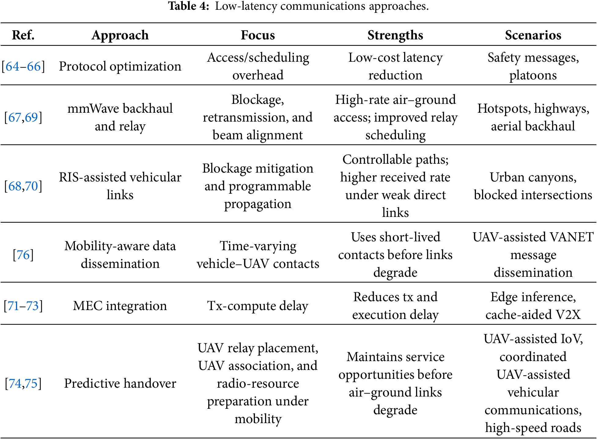
The methods above reduce latency from different parts of the UAV-assisted IoV service chain. Protocol optimization mainly reduces access and scheduling overhead, mmWave and RIS-related methods handle high-rate but blockage-sensitive air–ground links, MEC integration shortens the transmission-computation loop, and predictive handover focuses on mobility-induced interruption. Table 4 compares these approaches according to their technical focus, practical benefit, and suitable vehicular scenarios.
Beyond the low-latency approaches above, non-terrestrial 6G networking for autonomous aerial systems [77], 6G-oriented IoV edge computing [78], and semantic IoV communication [79] deserve attention in UAV-assisted IoV. They should not be treated as independent add-ons. Their value depends on the specific bottleneck in the vehicular scenario, such as high-speed mobility, blockage, insufficient sensing resolution, excessive raw-data transmission, or spectrum competition.
For high-speed highways, the main difficulty is not only insufficient bandwidth but also fast channel variation, frequent handover, and Doppler-induced link instability. Cell-free massive MIMO can reduce dependence on a single serving base station by allowing distributed access points to serve vehicles cooperatively. This may improve service continuity on high-mobility roads, but it also requires accurate CSI, tight synchronization, and reliable fronthaul/backhaul coordination. These requirements become more difficult when UAVs serve as temporary or mobile infrastructure with limited payload and energy.
THz and near-field communication can provide large bandwidth and fine-grained sensing or positioning resolution. Their use in IoV is attractive for high-volume cooperative perception and precise localization, but blockage, short transmission distance, beam misalignment, and hardware cost remain major constraints. Near-field IoV studies that jointly consider positioning accuracy, sensing precision, task offloading, and resource allocation show that future vehicular systems need to link communication resources with sensing and computing objectives [80]. When applied to UAV-assisted IoV, these ideas require additional modelling of aerial geometry, UAV trajectory, and propulsion energy.
RIS-assisted communication is useful when urban buildings, large vehicles, or roadside obstacles block air-ground and vehicle-to-infrastructure links. By reshaping the propagation path, RIS can improve the effective signal to noise ratio (SNR), reduce retransmission, and support backup beams for blockage-prone roads. However, RIS control introduces channel-estimation overhead, phase-configuration delay, and coordination requirements among RSUs, UAVs, and vehicles. The gain of RIS-assisted UAV-IoV therefore depends on whether the reduced blockage loss exceeds the added control cost.
Semantic communication is more suitable when vehicles or UAVs need to exchange task-relevant knowledge instead of raw sensing streams. For example, semantic knowledge sharing in IoV can reduce bandwidth consumption by transmitting extracted model or feature information rather than complete neural-network models [79]. In UAV-assisted IoV, this idea may reduce the burden of aerial backhaul and cooperative perception, but it depends on reliable semantic extraction and consistent knowledge representations across edge nodes. It should not be regarded as a direct replacement for raw sensing transmission in safety-critical tasks unless semantic errors and uncertainty are explicitly controlled.
Joint radar-communication waveform design improves spectrum efficiency by sharing radio resources for sensing and communication. In UAV-assisted vehicular ISCC, the same aerial platform may participate in sensing, data transmission, and computation-related task support. As a result, task scheduling, power allocation, beamforming, UAV trajectory, and radio resources become coupled in UAV-assisted vehicular ISCC [31] and UAV-assisted IoT ISCC [32]. This coupling makes waveform and resource design more difficult than in separate sensing or communication systems, especially under high vehicle mobility and limited UAV energy.
Overall, 6G-related technologies should be selected according to mobility, infrastructure density, sensing requirements, and backhaul capacity. A practical low-latency design should combine high-rate access with mobility prediction, sensing assistance, and computing-aware resource scheduling, while explicitly reporting CSI acquisition, synchronization, beam tracking, hardware complexity, and UAV energy cost.
3.4 UAV Energy Management and Endurance Optimization
Stable low-latency communication, relay service, sensing, and edge computing all depend on UAV endurance. Unlike ground RSUs or edge servers, UAVs operate under limited battery capacity and must spend energy on flight, hovering, communication, computation, and sensing. Endurance is therefore not only a flight problem; it directly affects service duration, link quality, task completion, coverage stability, and security robustness. A simple battery-evolution model can be written as
where
3.4.1 Green Energy-Aware Scheduling
Green-energy-aware scheduling treats available or harvestable energy as an active scheduling factor rather than as a passive constraint. A UAV can estimate solar irradiance or other harvestable energy over a short time window and combine this estimate with the state of charge (SoC) and state of health (SoH) to form an energy budget. Flight mode, hovering time, trajectory, attitude control, link selection, and transmission rate can then be adjusted according to this budget. When the reserve becomes insufficient, charging, battery swapping, or wireless power transfer may be triggered. The objective is to extend continuous service time, reduce service interruption, lower tail latency and total energy consumption, and maintain coverage quality.
Existing studies show several ways to include energy awareness in vehicular UAV services. Joint communication and resource optimization can improve energy efficiency, throughput, and fairness in UAV-to-vehicle (U2V)/V2V spectrum sharing while reducing outage probability under interference [81]. Renewable-energy-aware job scheduling considers latency and mobility constraints and incorporates low-carbon energy windows into task execution [82]. Federated-learning-enabled UAV-assisted vehicular edge computing can reduce communication overhead, training delay, and energy consumption through joint vehicle selection and resource allocation [83]. Energy-aware offloading has also been extended to joint management of AoI, energy consumption, and resource-leasing cost [44], while deployment- and content-aware caching can improve cache hit rate and reduce backhaul delay [84]. The reported energy gains should not be generalized without considering flight mode, payload weight, wind, battery degradation, and whether take-off and landing energy is included.
Green scheduling is most useful when the availability of harvested or low-carbon energy can be predicted with reasonable confidence. If the prediction is unreliable, the scheduler must maintain a conservative reserve, and the latency improvement observed in optimization may be reduced in deployment.
3.4.2 Collaborative Energy Harvesting and Task Offloading
Energy harvesting and task offloading should be designed together because the energy state changes the feasible execution location of tasks. Proximal execution and feature-level upload can shorten the backhaul path and reduce both end-to-end delay and tail latency. At the same time, SoC, SoH, and short-term energy-harvesting prediction can guide dynamic task diversion to avoid service loss caused by energy depletion. Hovering control, trajectory planning, and replenishment-window scheduling can coordinate the fly-hover-compute rhythm and maintain coverage stability for hotspots.
Photovoltaic harvesting and onboard edge computing have been used to enable near-cloud inference while reducing dependence on cloud backhaul and queueing delay [85]. Joint trajectory and power-offloading design shows that energy harvesting, propulsion cost, computation workload, and backhaul load should be considered together in mobile scenarios [86]. In UAV-assisted vehicular networks, flight trajectory and computation offloading can be jointly adjusted through queue-aware control to reduce service delay while keeping UAV energy consumption within a usable range [87]. Fixed-wing path planning [88], urban wind-aware energy functions [89], and energy-map-based path selection [90] further illustrate how environment-aware flight planning can reduce energy cost. In vehicular edge computing, long-term service requires joint control of energy-state evolution, harvesting, and offloading to reduce delay and energy deficit [63]. These approaches remain less reliable in shaded urban canyons, poor weather, or short missions where harvested energy is small compared with propulsion energy.
The common implication is that energy replenishment changes the offloading decision itself. A task that is feasible for a fully charged UAV may be risky for a UAV close to energy depletion. Task placement and energy planning should therefore be solved together.
3.4.3 Energy Balancing between Hovering and Mobility
Another important endurance issue is the trade-off between hovering and movement. A hovering UAV can provide stable local coverage and sensing for urban hotspots, but rotary-wing hovering consumes considerable power. A cruising or fixed-wing platform can cover long corridors more efficiently, but it cannot remain stationary over one road segment. The suitable flight mode depends on the service goal, road geometry, coverage requirement, and energy budget.
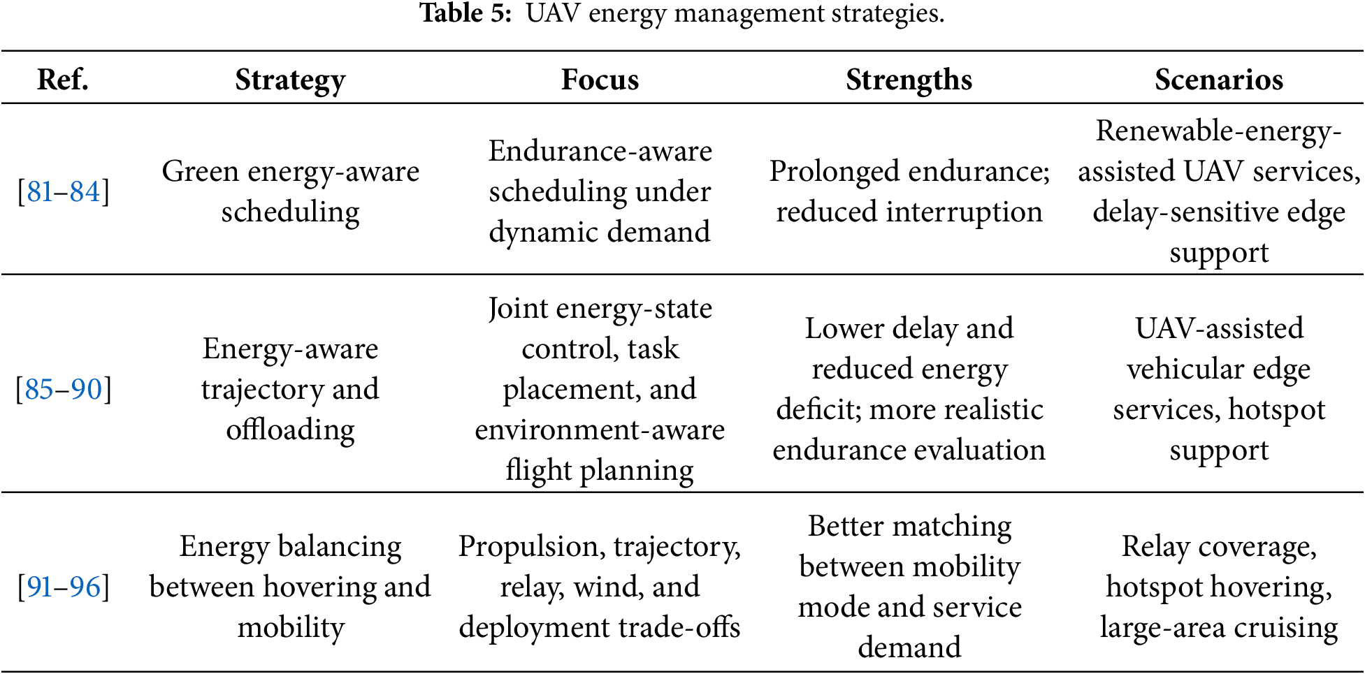
Energy balancing should not be treated as a single generic energy-saving problem. The fly-hover-communicate model for rotary-wing UAVs shows that hovering duration, flight trajectory, and communication time jointly determine mission energy [91]. UAV-assisted IoT trajectory planning further shows that completion time and energy consumption are coupled through the service route and task schedule [92]. A comparison of rotary-wing and fixed-wing flying networks suggests that hovering-capable platforms and cruising platforms should be selected according to whether the service target is a local hotspot or a road corridor [93]. Coupled trajectory and energy-management optimization for hybrid-electric UAVs indicates that energy-state evolution should be considered during flight planning rather than after the path has been fixed [94]. For UAV-assisted vehicular edge computing, joint deployment and trajectory optimization links UAV energy use with where computation services are placed along the road [95]. In 5G NR-V2X, transmit-power control and altitude planning directly affect the energy efficiency and reliability of UAV-based vehicular links [96]. Therefore, in UAV-assisted IoV, the practical choice is not simply hovering or cruising; it should match the road scene, expected service time, vehicle density, and available battery reserve. This scenario-dependent reading is important for UAV-assisted IoV deployment. Hotspot inspection in urban areas may favor rotary-wing hovering, whereas long highway corridors may favor cruising platforms or rotating UAV teams. Table 5 summarizes representative UAV energy-management strategies and their typical scenarios.
From the deployment perspective, UAV energy consumption includes propulsion energy, hovering energy, communication energy, sensing energy, and computing energy. These components are coupled. A trajectory that shortens the communication distance may require additional flight movement, while local onboard processing may reduce backhaul traffic but consume processor energy. Long-term service therefore requires energy-aware trajectory planning, multi-UAV rotation, charging stations, battery swapping, or cooperation with ground infrastructure [97]. Wind, payload, flight altitude, and safety constraints should also be included when evaluating endurance. Otherwise, an algorithm that performs well in simulation may be infeasible for long-duration vehicular service.
3.5 Security and Privacy Protection Technologies
As UAVs extend the operational space of IoV, security and privacy protection become more difficult. Vehicles, UAVs, RSUs, and edge servers exchange location information, sensor data, model parameters, offloading requests, control messages, and service records over open wireless links. A UAV may act as a relay, sensing node, lightweight edge server, or data-sharing point. If the UAV is compromised or jammed, the impact may propagate from communication to computation, cooperative perception, and traffic-control services. Therefore, UAV-assisted IoV requires protection of air-ground links, node identity, data integrity, location privacy, model updates, and offloading decisions, while still satisfying strict latency and energy constraints.
Physical-layer security is important because many UAV-to-ground links are line-of-sight (LoS) and highly exposed. The same channel condition that improves communication quality may also make the signal easier to intercept. A typical indicator is the achievable secrecy rate, which can be written as
where
Existing physical-layer security methods differ mainly in the channel features they exploit. Channel-aware secure transmission uses improved UAV-to-vehicle (U2V) channel models and maneuvering-aware propagation analysis to support secrecy-oriented trajectory design and joint beamforming-power optimization [6]. Doppler-aware U2V analysis further shows that six-degree-of-freedom UAV motion can change the multipath structure and weaken the fixed-beam assumption [98]. RIS-assisted transmission can reshape the propagation path, direct more reflected energy toward legitimate users, reduce eavesdropping probability, and improve secrecy rate in mobile environments [99]. In ISCC-oriented security, motion-induced Doppler shifts can also help detect eavesdroppers and support covert transmission [100]. Finite-blocklength secrecy design supports secure short-packet transmission under strict delay constraints [101]. UAVs may also serve as relays or carry artificial-noise jammers to protect multi-beam vehicular communication [102]. In RIS-assisted UAV systems, transmit power, RIS phase shift, and UAV trajectory can be jointly optimized for secrecy performance [103].
Physical-layer security is latency-friendly because it can provide protection at the transmission level without relying only on higher-layer protocols. Its limitation is that it often requires channel knowledge, eavesdropper-location assumptions, mobility prediction, or additional jamming/RIS control. In UAV-assisted IoV, it should therefore be regarded as a front-end protection layer that complements, rather than replaces, authentication, trust management, and privacy-preserving mechanisms.
3.5.2 Trust- and Cryptography-Based Security Mechanisms
Physical-layer methods cannot solve identity, accountability, and privacy problems. UAV-assisted vehicular networks are open, mobile, and cross-domain. Vehicles may use pseudonyms, UAV contacts may be short-lived, and service providers may belong to different administrative domains. Trust and cryptography-based mechanisms are therefore needed to authenticate participants, protect data integrity, control privacy exposure, and support accountable service coordination.
Lightweight device authentication is equally important in UAV-assisted IoV because UAVs and vehicles have limited contact time and limited computation resources. Authentication using a physical unclonable function (PUF) can reduce stored-secret exposure and support fast mutual verification [104].
Several upper-layer mechanisms have been studied for these purposes. Blockchain-based trust management can provide hierarchical ledger recording and data coordination in UAV-assisted vehicular environments [105]. Lightweight PBFT variants and HotStuff-based schemes can reduce consensus overhead under the resource and latency constraints of UAV networks [106]. Reputation and identity-assurance mechanisms can combine evaluator history with smart contracts to detect abnormal vehicles and suppress false information [107]. Anonymous certificates, distance bounding, and zero-knowledge-proof methods can protect authentication privacy, location proof, and geofencing compliance [108]. In distributed intelligence, secure aggregation can reduce information leakage from location data or raw images during federated learning [109], while differential privacy provides a quantitative privacy guarantee by limiting inference from model outputs [110]. Strong aggregation and federated ensemble methods further improve robustness against poisoning and backdoor attacks under non-independent and identically distributed IoV data [111]. Privacy-preserving methods have also been developed in SAGIN-assisted and UAV-edge collaborative systems by combining differential transfer learning, reinforcement learning, and adaptive privacy scheduling [112].
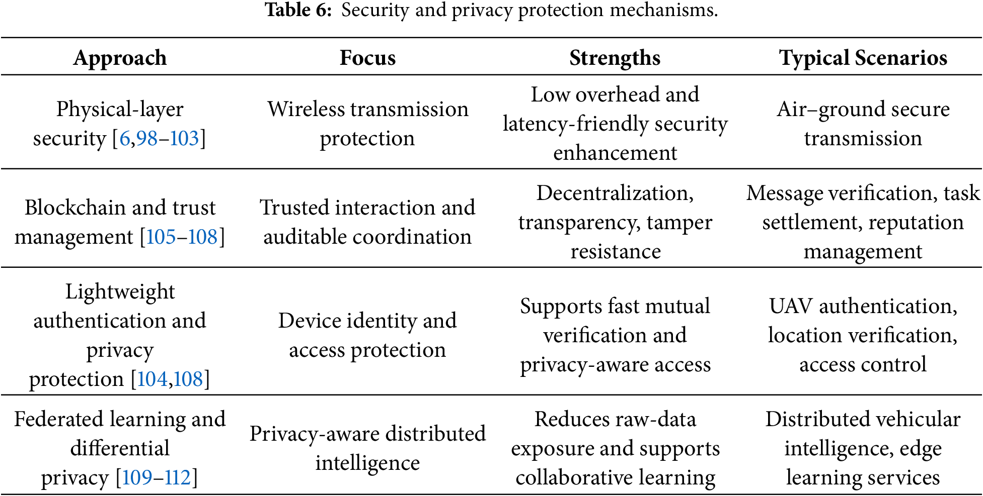
The main limitation of heavy security mechanisms is that they may conflict with the low-latency requirement of IoV. Blockchain consensus, frequent authentication, and privacy-preserving encryption can improve trust, but they also introduce storage, computation, and communication overhead. In ISCC-oriented UAV-assisted IoV, security design should therefore be lightweight and context-aware. Safety-critical messages may require fast authentication and integrity verification, while non-urgent sensing data can tolerate stronger privacy protection and delayed processing. Table 6 separates the main protection mechanisms by their protected object, practical advantage, and likely use scenario, which is more useful than treating security as a single module.
3.6 Intelligent Algorithm–Digital Twin Integration
Intelligent algorithms and digital twins are often mentioned together, but they serve different purposes. Learning algorithms are mainly used for prediction, classification, optimization, and control. A digital twin provides a virtual environment for representing vehicles, UAVs, RSUs, wireless links, and energy states. Their combination is useful because UAV-assisted IoV changes too quickly for every policy to be tested directly in the physical network. A twin can first be used to evaluate offloading, trajectory planning, resource allocation, anomaly detection, and service recovery with lower operational risk.
3.6.1 Physical-to-Virtual Mapping
The first requirement of a useful digital twin is accurate physical-to-virtual mapping. If the virtual state lags behind the physical network, later prediction and optimization may remain valid only in the simulated environment. UAV-assisted IoV is particularly sensitive to this problem because vehicle positions, UAV trajectories, RSU load, channel quality, task queues, and energy states change rapidly and interact with each other. A digital twin should therefore represent not only road geometry but also communication, computation, mobility, and energy states on a shared time basis.
At the technical level, full-system synchronization is the main difficulty. Digital twins can connect vehicle, road, UAV, and wireless-environment states across the cloud-edge-terminal continuum, forming a closed loop of perception, model construction, simulation, and feedback control [113]. Twin-assisted communication and resource orchestration can also predict severe scattering and multipath conditions in UAV-RIS-assisted vehicular networks, supporting timely adjustment of beam direction and power allocation [114]. Reinforcement learning has been used to adapt the width and update strength of virtual-physical mapping, improving mapping success and convergence speed [115]. At the platform level, twin migration and twin-enabled deployment have been studied for UAV-assisted vehicle-twin migration and 6G co-simulation platforms that connect wireless links, three-dimensional environments, and AI models [116]. Three-layer architectures combining digital twins, high-altitude platforms, and physical execution layers have also been proposed for state synchronization, trajectory simulation, privacy-aware task offloading, and collaborative resource allocation among UAVs, vehicles, and RSUs [117].
Thus, the key issue is not how to visualize the virtual network, but how to keep the virtual and physical systems consistent while decisions are being made. A twin updated every few seconds may be sufficient for planning, but it may be too slow for handover control, emergency perception, or ultra-low-latency task offloading.
3.6.2 Intelligent Prediction, Anomaly Detection, and Self-Healing
After observation and synchronization data are available, intelligent algorithms can be used for load forecasting, risk identification, anomaly detection, and recovery control. These functions are relevant to UAV-assisted IoV because abnormal sensing, degraded communication, overloaded computing resources, or trajectory deviations may directly threaten driving safety and service continuity. Static rules are often insufficient when workload, channel condition, UAV energy, and traffic density change simultaneously. AI-based spatiotemporal models can integrate multimodal sensing, graph relations, long sequences, and uncertainty estimates to support earlier and more adaptive decisions.
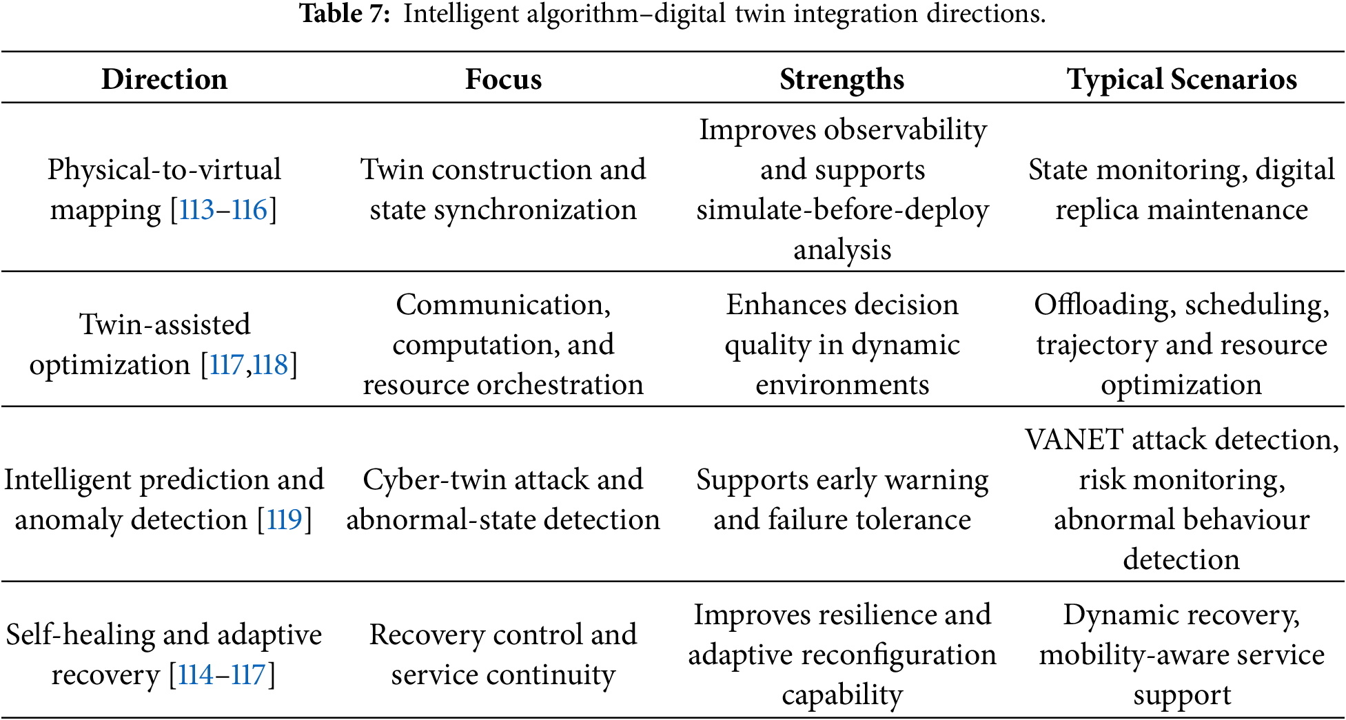
The operational value of prediction depends on whether it can change the decision before the service fails. Prediction-enhanced orchestration can estimate task arrival, link quality, edge capacity, and battery state from spatiotemporal UAV observations, and then adjust resource orchestration and offloading to reduce end-to-end delay and congestion risk [117]. Spatiotemporal graph models have been used to predict urban traffic conditions from UAV monitoring data, although viewpoint changes and limited continuous annotation may reduce accuracy [118]. Cyber-twin attack detection for VANETs shows that mirrored network states and learning models can be used to detect abnormal behaviour and shorten detection latency [119]. These functions also support self-healing: when model drift, sensing errors, link degradation, or node failure are detected, the system can trigger backup nodes, reroute traffic, switch access links, degrade non-critical services, or retrain models. Prediction and self-healing should therefore be evaluated as operational mechanisms rather than only as algorithmic modules. Useful evaluations should report prediction uncertainty, recovery delay, service interruption, and the cost of false alarms. Table 7 summarizes the main directions of intelligent algorithm–digital twin integration according to their focus, strengths, and typical scenarios.
Learning-based methods are increasingly used for offloading, trajectory planning, load prediction, and resource control in UAV-assisted IoV because the system state is difficult to represent with fixed analytical assumptions. Vehicle mobility, wireless channels, task arrivals, UAV energy, and edge-server load change simultaneously. Multi-objective DRL has been applied to UAV-assisted MEC in IoV to minimize delay and energy consumption while maximizing completed tasks [120]. This type of method is suitable for dynamic vehicular environments where a single objective is insufficient, but it also shows that UAV-assisted IoV optimization should not be evaluated by average delay alone.
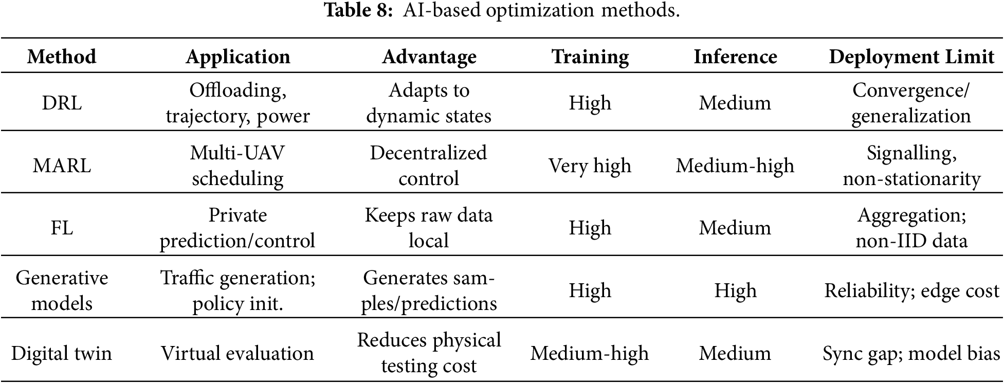
Learning-based optimization still requires careful deployment analysis. DRL can learn dynamic offloading, trajectory, or power-control policies, but its performance depends on reward design, training scenarios, and state representation. A policy trained under a fixed vehicle density or channel model may not generalize to sudden congestion, emergency events, or different road structures. Multi agent reinforcement learning (MARL) is suitable for multi-UAV coordination, where each UAV makes local decisions while affecting global communication and computing performance. However, the learning process becomes non-stationary because the policy of one UAV changes the environment observed by others, and additional inter-UAV signalling may be required. Federated learning (FL) can reduce the need to upload raw vehicular data, but repeated model aggregation introduces communication rounds and may be unstable under non-independent and identically distributed traffic data. Generative models can support traffic-scenario generation or policy initialization, but generated scenarios should not replace real-world validation unless mobility, channel, and workload distributions are carefully checked. Digital twins can reduce physical testing cost, but twin maintenance competes with task processing for limited edge resources; their decisions are reliable only when the virtual model is synchronized with real traffic and network states [33]. Table 8 summarizes the application scope, advantages, overhead, and deployment limitations of representative AI-based methods.
3.7 Comparative and Critical Analysis of Existing Studies
The purpose of the comparative analysis is not to rank the reviewed studies, but to show how different modelling assumptions lead to different conclusions. Studies focusing on task offloading usually emphasize delay and energy consumption, whereas ISCC-oriented studies also need to consider sensing quality, information freshness, synchronization, and UAV mobility. This difference explains why results obtained from pure communication or computation models cannot be directly transferred to UAV-assisted ISCC-IoV. Table 9 summarizes representative studies from several technical directions and highlights their modelling focus, advantages, and limitations.
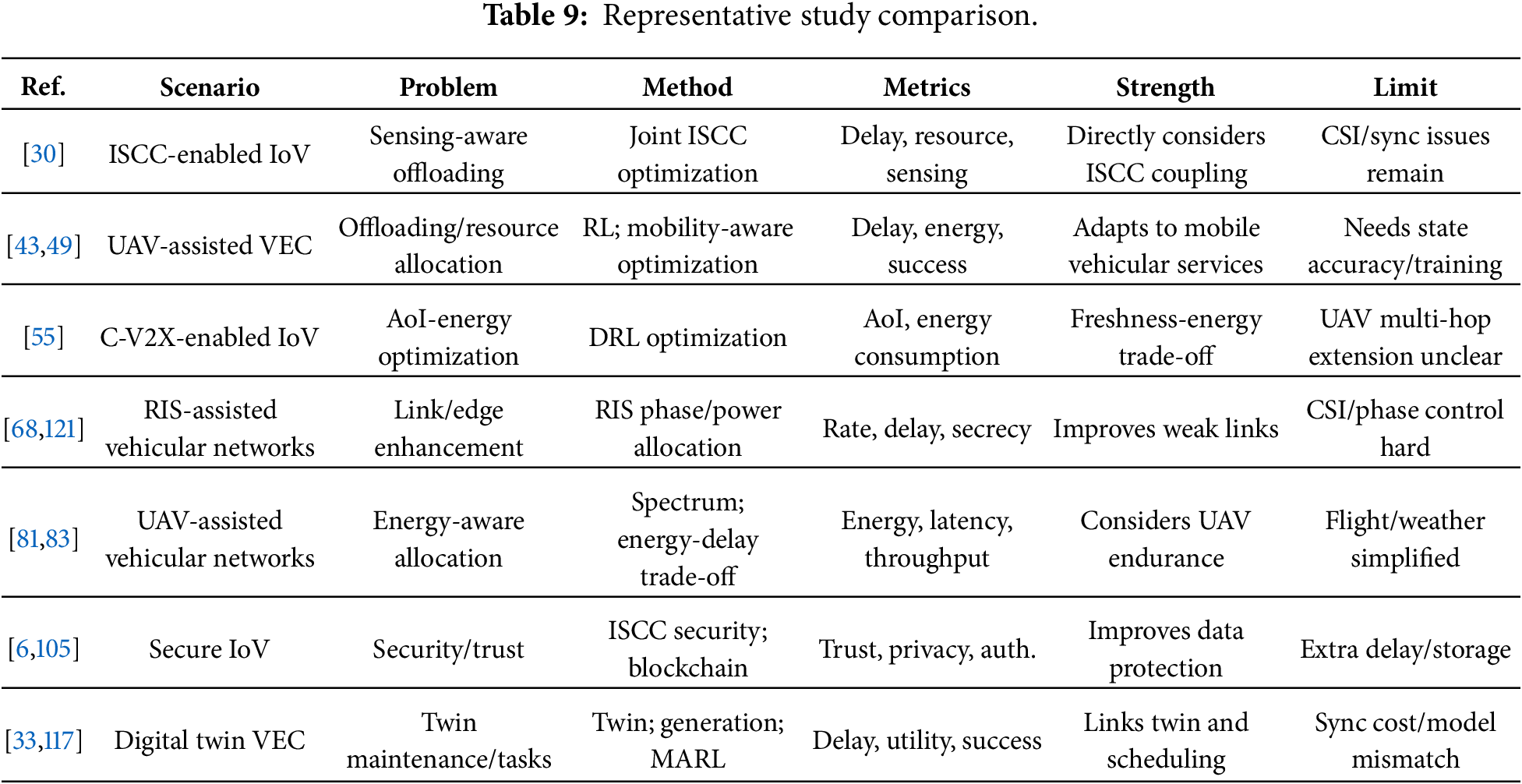
Overall, the literature indicates that UAV-assisted IoV should be evaluated through multi-dimensional metrics rather than a single performance indicator. Latency reduction may increase energy consumption; stronger security may increase computation and signalling overhead; better sensing quality may require more communication and computing resources; and digital-twin accuracy may depend on frequent state synchronization. Future research should therefore focus on low-complexity ISCC-aware algorithms, robust learning under imperfect observations, and testbeds that jointly evaluate mobility, communication, sensing, computing, and energy under the same scenario settings.
4 Typical Application Scenarios
The same UAV configuration may perform differently under different road conditions, so its role has to be considered together with the road environment. Fig. 4 shows the general layout of urban roads, highways, rural areas, emergency response, intelligent traffic management, cooperative perception and autonomous driving. The density of infrastructure, speed of vehicles, traffic congestion, backhaul quality, computing demand and safety requirements are all different for these scenes. This section will introduce three representative cases of urban roads, highways and rural roads.
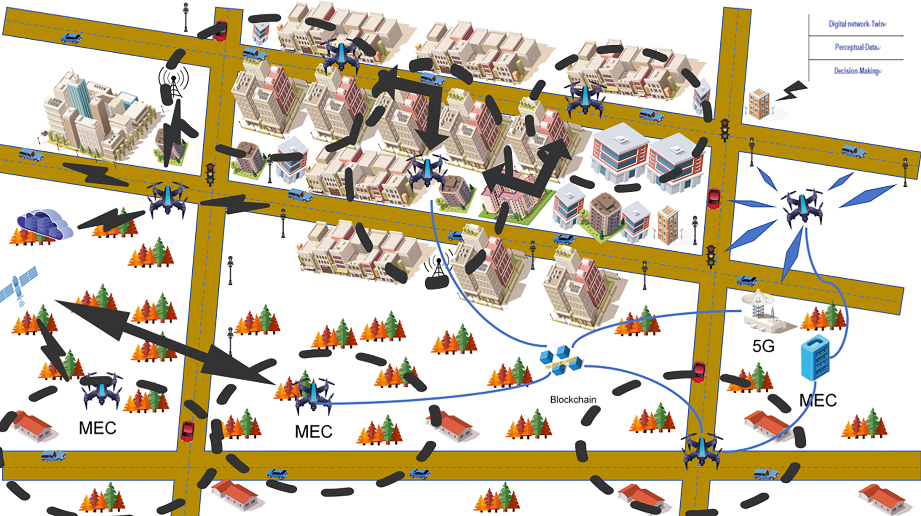
Figure 4: Typical application scenarios.
In practice, the main problem is uneven service availability. Some road segments suffer from weak connectivity, limited local computation, poor sensing coverage, or temporary overload. UAVs can support these weak points of the ground network, but the service target differs across scenarios. Urban roads often require short-term relief for congestion, blockage, and dense user access; highways require long-distance continuity, stable handover, and Doppler-resilient links; rural roads lack infrastructure and backhaul and therefore need coverage extension and emergency support.
Urban roads contain dense intersections, high building blockage, mixed traffic, and frequent local congestion. Although overall network coverage may be available, street canyons and overloaded intersections can still create short-term service gaps. In this setting, UAVs are more suitable as temporary aerial support nodes for coverage recovery, cooperative sensing, and edge assistance than as permanent high-altitude base stations.
Existing studies have used UAVs as auxiliary aerial RSUs to improve V2X connectivity, distribute roadside workload, and support hotspot services. Digital twins have been applied to resource allocation in vehicular networks that include UAVs and RIS [114]. The performance of RIS supported UAV vehicular links under multiple interferers has been evaluated [121]. UAV assisted RSU deployment has been studied to improve V2X connectivity and service coverage [122]. Computation offloading in UAV enabled mobile edge computing has also been reviewed [123]. The main deployment limitation is that urban UAVs must operate under strict flight rules, obstacle avoidance, privacy protection, and interference management.
Highway scenarios are dominated by high mobility, long road segments, fast channel variation, and sparse infrastructure. UAVs can be deployed near ramps, interchanges, accident scenes, and sections with weak ground coverage to provide aerial RSU functions or temporary base-station support [124]. In cooperation with the ground network, UAV assistance can support relay selection and transmission scheduling for platooning or accident-warning services [69], while highway-oriented UAV deployment can extend service range and improve service distribution [125].
High-frequency highway links are sensitive to vehicle blockage, Doppler spread, and beam misalignment. UAV-assisted mmWave vehicular studies indicate that relay selection and transmission scheduling can reduce blockage loss [69]. In the same type of high-frequency air-ground link, UAV trajectory and altitude control affect outage probability, delay, and energy consumption [126]. These methods are more suitable for controlled highway sections with predictable routes and available backhaul. Long open highways with few charging points or strict airspace restrictions still face endurance and regulatory constraints.
Rural roads usually have sparse RSUs, limited cellular coverage, weak backhaul, and difficult maintenance conditions. Vehicles in these areas may not require the same density of edge computing as in urban intersections, but emergency warning, road-condition monitoring, and basic connectivity are still important [127]. UAVs can provide temporary coverage, relay support, and aerial sensing where fixed infrastructure is absent or damaged.
Compared with urban and highway scenarios, rural deployment places more emphasis on endurance, wide-area coverage, and operation cost. UAVs may need to cover longer distances with fewer charging or maintenance facilities. LEO satellite backhaul, delay-tolerant task scheduling, lightweight sensing, and multi-UAV rotation can improve service continuity, but they also increase coordination and cost. For this reason, rural UAV-assisted IoV should be evaluated not only by low latency, but also by coverage recovery time, flight duration, backhaul availability, and maintenance feasibility.
The three scenarios above show that UAV-assisted ISCC-IoV cannot be evaluated with a single service metric. Urban roads are limited mainly by blockage, congestion, and privacy-sensitive sensing; highways are limited by mobility, beam tracking, and relay continuity; rural roads are limited by missing infrastructure and backhaul. Table 10 compares these scenario-dependent bottlenecks, ISCC requirements, and deployment concerns so that later research directions can be linked to practical road conditions rather than to a generic UAV service model.
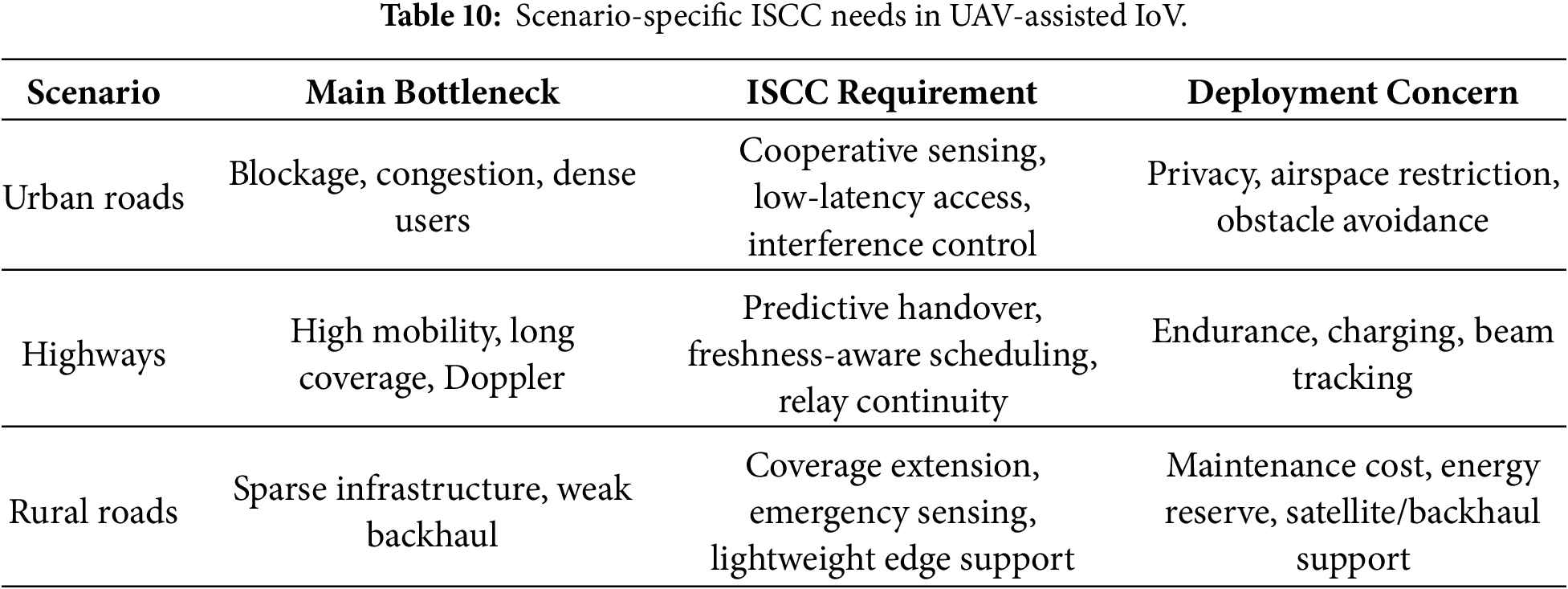
5 Open Challenges and Research Prospects
Current studies show that UAV-assisted IoV has moved beyond simple coverage extension. Early work often treated UAVs as temporary base stations that strengthen signals in uncovered or overloaded areas. The problem is now broader: vehicles, RSUs, UAVs, edge servers, and cloud platforms jointly support sensing, communication, computation, and control. A change in one part of the system can affect the others. Future research should therefore move from single-algorithm improvement toward system-level design that remains interpretable and reliable under dynamic traffic, limited resources, and deployment constraints.
5.1 Cross-Layer Collaborative Design
A major difficulty in cross-layer design is that communication, computation, sensing, and mobility are often optimized in separate layers. Weighted objective functions can combine these variables in one mathematical model, but they may not reflect the operating logic of a real system if all decisions are optimized at the same time scale. Wireless resource allocation is usually performed in milliseconds, task offloading and queue adjustment operate over seconds, and UAV trajectory or energy-replenishment planning may require a much longer horizon. Treating all variables with the same update period can make the model difficult to deploy.
The interactions among layers are also service-dependent. Moving a UAV to improve the line-of-sight link may increase propulsion energy or reduce sensing coverage. Offloading more tasks to the aerial edge node may reduce vehicle-side computation but increase backhaul delay. Improving sensing accuracy may generate additional communication and computing load. These examples show that the key issue is not simply to optimize more variables, but to identify which variables should be coupled for a given service.
A practical direction is hierarchical closed-loop control. The lower layer manages fast access, link adaptation, and beam tracking; the middle layer controls task queues, offloading, and computing resources; and the upper layer plans UAV trajectory, formation, battery replacement, and long-term coverage. These layers do not need to find a global optimum at every instant. Instead, they should exchange compact state information and trigger replanning only when traffic load, channel condition, energy state, or service priority changes significantly.
Future cross-layer design should also include task priority, dependency, and failure cost. Some sensing tasks can tolerate lower resolution to save time, whereas safety-critical warnings may need local execution or redundant transmission. When such differences are included, system decisions become closer to the operational requirements of traffic safety services.
5.2 Adaptation to Real Scenarios
Another challenge is the gap between simplified evaluation and real road environments. Urban roads contain buildings, tunnels, trees, pedestrians, and temporary construction areas; highways contain high-speed vehicles, sparse base stations, accidents, and weather-related disturbances; and rural roads often suffer from weak signal coverage, limited backhaul, and difficult maintenance. If UAV-assisted IoV is to be deployed in practice, simulation settings should gradually include these conditions.
The main issue is not the use of simulation itself, but oversimplified assumptions. Vehicular trajectories should be based on real traffic-flow data when possible. Channel models should include buildings, tunnels, foliage, vehicle-body blockage, and weather changes. UAV energy models should consider not only flight distance but also hovering, climbing, turning, wind resistance, payload, communication load, and computing load. Otherwise, an algorithm that performs well in a simplified simulation may fail when deployed in low-altitude road environments.
Evaluation should also move beyond average latency and average energy consumption. Safety-related services should report worst-case delay, service interruption time, coverage recovery time, task-deadline violation, and failure cases. Learning-based algorithms should report convergence time, training cost, inference delay, and sensitivity to vehicle density, channel state, and UAV battery level. A staged evaluation process is therefore needed: controlled simulation for basic comparison, real maps and trajectories for mobility realism, refined channel and energy models for deployment analysis, and semi-physical or small-scale road tests before large-scale operation.
Practical deployment also requires more attention than most simulation studies provide. Recent UAV-assisted ISCC studies show that sensing, communication, task scheduling, UAV trajectory, and resource allocation are coupled rather than separate factors [31]. UAV-assisted air-ground collaborative ISCC further confirms that trajectory and resource allocation should be considered together when aerial nodes participate in service delivery [32]. UAV energy and trajectory-control studies further show that propulsion cost, altitude, communication power, and air-ground link conditions must be considered jointly [96]. Doppler-aware UAV-to-vehicle channel studies also indicate that six-dimensional mobility affects the reliability of high-mobility air-ground links [98], while RIS-assisted vehicular communication highlights the coupling between blockage, CSI acquisition, and phase control [121]. Table 11 summarizes several important deployment issues. These issues are not independent. For example, UAV battery limitation constrains sensing frequency and communication power; Doppler effects and imperfect CSI reduce the reliability of beam tracking; and backhaul limitation can make cooperative perception ineffective even when the air-ground access link is stable.
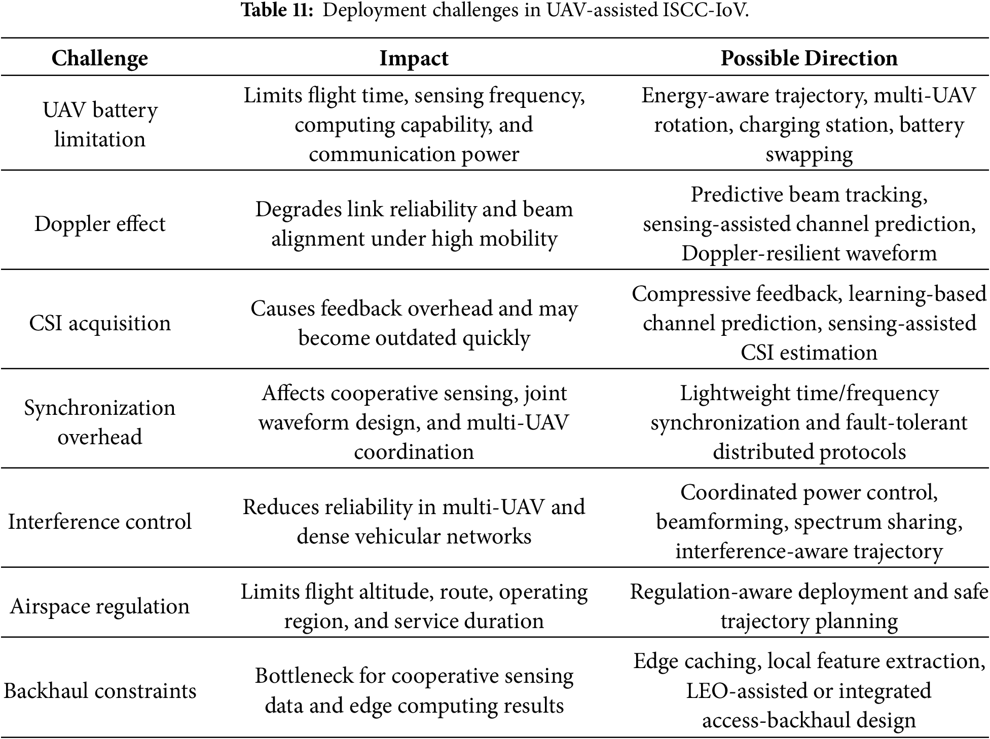
5.3 Security, Trustworthiness, and Continuous Operation
When UAVs become part of the IoV infrastructure, security and continuous operation can no longer be treated as add-on issues. A UAV-assisted system collects vehicle positions, road images, task requests, link states, and service records. Many of these data are sensitive. If an aerial node is captured, spoofed, or tampered with, the damage may propagate from the communication layer to traffic control and task scheduling.
The attack surface also changes. Traditional IoV already faces identity forgery, message tampering, privacy leakage, and malicious data injection. The addition of UAVs introduces air-ground links, aerial sensing data, mobile edge nodes, and cross-domain control commands. Incorrect images, false link states, or manipulated traffic-flow information may lead to wrong offloading, wrong trajectory planning, or delayed risk warning. Protection must therefore cover not only message transmission, but also sensing-data sources, model updates, and the execution of control decisions.
Privacy protection has to be balanced with service accuracy. More uploaded data usually improves model inference and resource scheduling, but also increases the risk of exposing vehicle identity, trajectory, and driving behaviour. A better design is to reduce unnecessary data at the source. If vehicle-side preprocessing can extract the required features, raw images need not be uploaded. If traffic density is sufficient for a service, vehicle identifiers should be removed. When distributed learning is used, gradient leakage and membership inference should also be considered. Privacy is therefore a process-level requirement that covers collection, transmission, storage, model training, and service use.
Service continuity is closely tied to power and maintenance. Unlike fixed base stations, UAVs cannot stay in the air for long periods without charging or replacement. Return flights, long hovering time, wind, payload weight, and poor weather may interrupt service even when the communication scheme works well in simulation. Solar assistance, battery swapping, and wireless charging can help, but they introduce station-layout and scheduling costs.
Future energy management should be evaluated by service continuity rather than by single-task energy consumption alone. A policy that minimizes energy in one round may still leave no reserve for the next emergency. A small energy budget may also reduce coverage on important road sections. Rotation planning, failure takeover, and maintenance scheduling should therefore be part of the architecture.
Reliable operation also requires clear responsibility boundaries. If an offloaded task times out, the failure may come from the algorithm, the link, the edge scheduler, or the UAV state. Technical papers seldom specify how these faults are recorded and assigned. In actual transportation networks, auditable logs, interpretable decisions, and failure analysis mechanisms will be needed, especially when UAVs interact with traffic management and airspace control.
Security, trustworthiness, and continuous operation are thus basic conditions for long-term UAV-assisted IoV. A system with low average delay will not be acceptable if it leaks sensitive trajectories or fails under a single aerial-node fault. The next stage of research should place security, privacy, energy, maintenance, and governance inside the architecture design rather than treating them as separate follow-up problems.
5.4 Simulation Tools, Datasets, and Evaluation Metrics
A systematic evaluation of UAV-assisted IoV requires suitable simulation tools, mobility data, network models, task models, and evaluation metrics. Unlike conventional vehicular networking or autonomous-driving perception, UAV-assisted IoV still lacks a unified open benchmark that simultaneously covers vehicular mobility, UAV trajectory, air-ground channel, sensing tasks, edge-computing workload, and UAV energy consumption. Therefore, most studies combine different tools and datasets according to their research focus, and the resulting performance comparisons should be interpreted with caution. Recent UAV-assisted intelligent transportation system (ITS) reviews emphasize the role of simulation testbeds and datasets in traffic monitoring, congestion management, emergency response, and aerial perception tasks [128]. A related machine-learning review further compares aerial datasets and models used for UAV-assisted ITS evaluation [129]. These resources do not yet form a complete ISCC benchmark, but they indicate how traffic traces, road maps, mobility simulators, network simulators, aerial perception datasets, and digital-twin environments can support different parts of UAV-assisted IoV evaluation.
The reviewed studies can be roughly divided into four groups. The first group uses real vehicular or traffic-flow datasets to improve mobility realism. For example, UAV-assisted vehicular edge computing has been evaluated using the Shenzhen Futian IoV trajectory dataset and a grid-based simulation setting [63], while mobility-aware task offloading has used expressway vehicle trajectories to support vehicle-location prediction and resource allocation [49]. Traffic-flow prediction in UAV-based urban traffic monitoring has also been evaluated using public traffic datasets such as California Performance Measurement System (PeMS) datasets, including PeMSD3, PeMSD4, PeMSD7, PeMSD8, PeMS-BAY, and METR-LA [118]. The second group combines map data, traffic simulation, and network simulation. A network slicing framework for UAV-assisted vehicular networks uses OpenStreetMap (OSM), SUMO, NS-3, and a long term evolution vehicle-to-everything (LTE-V2X) extension module to evaluate delay, throughput, jitter, and packet loss [58]. Urban aerial network infrastructure studies have also used OMNeT++/INET together with SUMO-based mobility scenarios [66]. The third group focuses on UAV-assisted ITS datasets and aerial perception evaluation. Recent surveys summarize UAV-enabled ITS application scenarios [128] and compare representative machine-learning models on aerial datasets [129], which is useful for understanding the perception-data side of UAV-assisted transportation systems. The fourth group constructs UAV or low-altitude digital-twin environments, such as Unity- and AirSim-based simulation for UAV perception and operational digital-twin evaluation [36]. In addition, UAV-mounted cloudlet studies [56], resource-pricing UAV-MEC studies [57], and computing-power-pool studies [60] still rely on customized numerical simulations with synthetic task arrivals, channel settings, and resource configurations. Table 12 summarizes representative datasets and simulation environments reported in the reviewed studies. The purpose of this table is not to claim that these resources are already unified benchmarks, but to show which parts of UAV-assisted IoV evaluation they can support. In practice, most of them still need additional UAV energy models, air-ground channel models, task generators, sensing modules, and edge-computing workload models before they can evaluate a complete ISCC-oriented system.
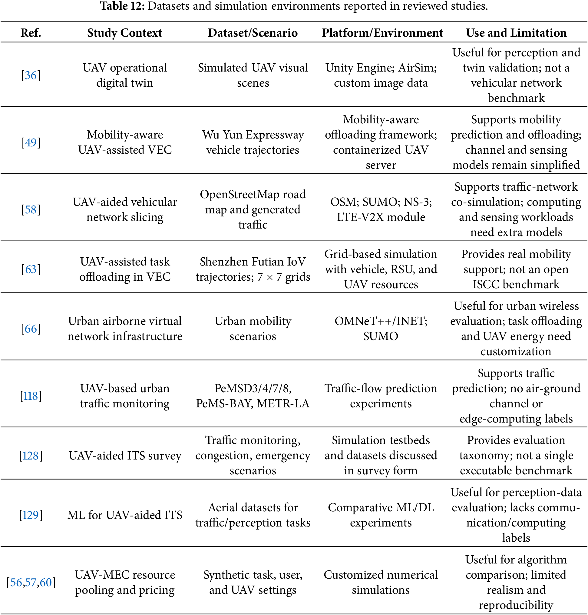
The common metrics should also be reported more consistently. Communication performance can be evaluated through latency, throughput, packet delivery ratio, jitter, and handover interruption. Computing performance can be measured by task completion time, offloading success ratio, CPU utilization, and queueing delay. Sensing-related evaluation should include perception coverage, sensing accuracy, localization error, and information freshness. UAV operation should be reported through propulsion energy, hovering time, flight duration, and remaining battery. For ISCC-oriented studies, average values alone are not sufficient. Worst-case delay, AoI, convergence time, computational complexity, sensitivity to vehicle density, and sensitivity to UAV battery status should also be included. A useful future direction is to build open benchmark environments that combine vehicular mobility, UAV trajectories, air-ground channels, sensing tasks, edge-computing workloads, and energy models under the same scenario settings.
This review examined UAV-assisted IoV from an integrated sensing, communication, and computing perspective. Compared with ground-only vehicular networks, UAV-assisted IoV can provide flexible coverage, temporary relay, mobile sensing, and lightweight edge computing support in urban canyons, highways, rural roads, and emergency areas. UAVs, however, should be seen as complementary aerial nodes rather than replacements for RSUs, base stations, and cloud/edge infrastructure.
The main difficulty is no longer communication coverage alone. The system has to balance sensing quality, communication reliability, computing latency, information freshness, energy consumption, security, and deployment feasibility. Task offloading, resource allocation, low-latency communication, energy management, security protection, AI-based optimization, and digital twin modelling should be evaluated under a cross-layer ISCC view. Cell-free massive MIMO, THz communication, RIS, semantic communication, and joint radar-communication waveform design may improve future systems, but they also bring CSI acquisition, synchronization, beam tracking, and hardware-complexity issues.
For practical deployment, more attention is needed on UAV battery replacement, backhaul limits, Doppler effects, synchronization, airspace regulation, and long-term maintenance. Open simulation tools and real vehicular trajectories should be used more consistently, and future experiments should report not only average results but also worst-case delay, recovery cost, convergence time, and failure cases. These issues will determine whether UAV-assisted IoV can move from emergency support and small-scale trials to regular transportation infrastructure.
Acknowledgement: Not applicable.
Funding Statement: This work was supported by the National Natural Science Foundation of China (Grant No. 62402081), the Science and Technology Research Program of Chongqing Municipal Education Commission (Grant Nos. KJZD-K202201203, KJQN202301258, KJQN202400645), the Foundation of Intelligent Ecotourism Subject Group of Chongqing Sanxia University of Science and Technology (Grant No. zhlv-20221004), and the Natural Science Foundation of Chongqing, China (Grant No. CSTB2025NSCQ-GPX0246), and Green Ecological Water Conservancy and Electric Power Engineering Research Center, Yunnan Water Resources and Hydropower Vocational College (Grant No. 2026YSZSYS006).
Author Contributions: Chao He: Conceptualization, Methodology, Supervision, Project administration, Resources, Funding acquisition, Writing—review & editing. Dongfeng Fu: Investigation, Formal analysis, Writing—original draft, Writing—review & editing, Visualization. Xin Xie: Investigation, Formal analysis, Writing—review & editing. Jinkui Zhang: Supervision, Resources, Writing—review & editing. Sirui Zhang: Investigation, Visualization, Writing—review & editing. Zheng Zhang: Supervision, Project administration, Writing—review & editing. All authors reviewed and approved the final version of the manuscript.
Availability of Data and Materials: Data sharing is not applicable to this article as no datasets were generated or analyzed during the current study.
Ethics Approval: Not applicable.
Conflicts of Interest: The authors declare no conflicts of interest.
References
1. Hemmati H, Zarei M, Souri A. UAV-based Internet of Vehicles: a systematic literature review. Intell Syst Appl. 2023;18(19):200226. doi:10.1016/j.iswa.2023.200226. [Google Scholar] [CrossRef]
2. Hu J, Chen C, Cai L, Khosravi MR, Pei Q, Wan S. UAV-assisted vehicular edge computing for the 6G Internet of Vehicles: architecture, intelligence, and challenges. IEEE Commun Stand Mag. 2021;5(2):12–8. doi:10.1109/MCOMSTD.001.2000017. [Google Scholar] [CrossRef]
3. Gao B, Liu J, Zou H, Chen J, He L, Li K. Vehicle-road-cloud collaborative perception framework and key technologies: a review. IEEE Trans Intell Transp Syst. 2024;25(12):19295–318. doi:10.1109/TITS.2024.3459799. [Google Scholar] [CrossRef]
4. Alaya H, Ben Letaifa A, Rachedi A. State of the art and taxonomy survey on federated learning and blockchain integration in UAV applications. J Supercomput. 2025;81(5):655. doi:10.1007/s11227-025-07124-x. [Google Scholar] [CrossRef]
5. Zhang T, Grzelak D, Zhao W, Islam MA, Fricke H, Aßmann U. A review on the construction, modeling, and consistency of digital twins for advanced air mobility applications. Drones. 2025;9(6):394. doi:10.3390/drones9060394. [Google Scholar] [CrossRef]
6. He C, Wang W, Jiang W, He Z, Wang J, Xie X. Security for the Internet of Vehicles with integration of sensing, communication, computing, and intelligence: a comprehensive survey. Sensors. 2025;25(16):5119. doi:10.3390/s25165119. [Google Scholar] [PubMed] [CrossRef]
7. Chughtai O, Qadri NN, Kaleem Z, Yuen C. Drone-assisted cooperative routing scheme for seamless connectivity in V2X communication. IEEE Access. 2024;12(20):17369–81. doi:10.1109/ACCESS.2024.3359273. [Google Scholar] [CrossRef]
8. Gupta A, Fernando X. Federated reinforcement learning for collaborative intelligence in UAV-assisted C-V2X communications. Drones. 2024;8(7):321. doi:10.3390/drones8070321. [Google Scholar] [CrossRef]
9. Wang Y, He Y, Yu FR, Lin Q, Leung VCM. Efficient resource allocation in multi-UAV assisted vehicular networks with security constraint and attention mechanism. IEEE Trans Wirel Commun. 2023;22(7):4802–13. doi:10.1109/TWC.2022.3229013. [Google Scholar] [CrossRef]
10. Liu S, Bai Y. Multiple UAVs collaborative traffic monitoring with intention-based communication. Comput Commun. 2023;210(2):116–29. doi:10.1016/j.comcom.2023.08.005. [Google Scholar] [CrossRef]
11. Sun G, Wang Y, Sun Z, Wu Q, Kang J, Niyato D, et al. Multi-objective optimization for multi-UAV-assisted mobile edge computing. IEEE Trans Mob Comput. 2024;23(12):14803–20. doi:10.1109/TMC.2024.3446819. [Google Scholar] [CrossRef]
12. Alnakhli M. Optimizing spectrum efficiency in 6G multi-UAV networks through source correlation exploitation. J Wireless Commun Netw. 2024;2024(1):6. doi:10.1186/s13638-023-02332-6. [Google Scholar] [CrossRef]
13. Zakaryia SA, Meaad M, Nabil T, Hussein MK. Offloading/resource allocation for multi-UAV asset edge computing with multi-agent deep reinforcement learning. Computing. 2025;107(5):126. doi:10.1007/s00607-025-01472-5. [Google Scholar] [CrossRef]
14. Shoaib M, Husnain G, Khan M, Ghadi YY, Lim S. Decentralized resource allocation in UAV communication networks through reward based multi agent learning. Sci Rep. 2025;15(1):33122. doi:10.1038/s41598-025-18353-8. [Google Scholar] [PubMed] [CrossRef]
15. Liu G, Dai F, Huang B, Qiang Z, Wang S, Li L. A collaborative computation and dependency-aware task offloading method for vehicular edge computing: a reinforcement learning approach. J Cloud Comput. 2022;11(1):68. doi:10.1186/s13677-022-00340-3. [Google Scholar] [CrossRef]
16. Fan W, Su Y, Liu J, Li S, Huang W, Wu F, et al. Joint task offloading and resource allocation for vehicular edge computing based on V2I and V2V modes. IEEE Trans Intell Transp Syst. 2023;24(4):4277–92. doi:10.1109/TITS.2022.3230430. [Google Scholar] [CrossRef]
17. He C, Jiang W, Wang X, Wang W, Xie X. Generative AI-enhanced task offloading strategy for the IoV: an RSU-RSU load-balancing perspective. IEEE Netw Lett. 2025;7(3):161–5. doi:10.1109/LNET.2025.3542094. [Google Scholar] [CrossRef]
18. Cao B, Li Z, Liu X, Lv Z, He H. Mobility-aware multiobjective task offloading for vehicular edge computing in digital twin environment. IEEE J Sel Areas Commun. 2023;41(10):3046–55. doi:10.1109/JSAC.2023.3310100. [Google Scholar] [CrossRef]
19. Awada U, Zhang J, Chen S, Li S, Yang S. Resource-aware multi-task offloading and dependency-aware scheduling for integrated edge-enabled IoV. J Syst Archit. 2023;141(8):102923. doi:10.1016/j.sysarc.2023.102923. [Google Scholar] [CrossRef]
20. Liu C, Wang H, Zhao M, Liu J, Zhao X, Yuan P. Dependency-aware online task offloading based on deep reinforcement learning for IoV. J Cloud Comput. 2024;13(1):136. doi:10.1186/s13677-024-00701-0. [Google Scholar] [CrossRef]
21. Li C, Chen Q, Chen M, Su Z, Ding Y, Lan D, et al. Blockchain enabled task offloading based on edge cooperation in the digital twin vehicular edge network. J Cloud Comput. 2023;12(1):120. doi:10.1186/s13677-023-00496-6. [Google Scholar] [CrossRef]
22. Khan AA, Laghari AA, Shafiq M, Awan SA, Gu Z. Vehicle to everything (V2X) and edge computing: a secure lifecycle for UAV-assisted vehicle network and offloading with blockchain. Drones. 2022;6(12):377. doi:10.3390/drones6120377. [Google Scholar] [CrossRef]
23. Chen T, Wang S, Fan X, Zhang X, Luo C, Hong Y. UAV-assisted multi-object computing offloading for blockchain-enabled vehicle-to-everything systems. Comput Mater Contin. 2024;81(3):3927–50. doi:10.32604/cmc.2024.056961. [Google Scholar] [CrossRef]
24. Pang S, Tang Y, Zhai X, Tong S, Wan Z. Blockchain-based UAV-assisted mobile edge computing for dual game resource allocation. Appl Sci. 2025;15(7):4048. doi:10.3390/app15074048. [Google Scholar] [CrossRef]
25. Li C, Dong M, Fu Y, Yu FR, Cheng N. Integrated sensing, communication, and computation for IoV: challenges and opportunities. IEEE Commun Surv Tutor. 2026;28(1):1136–68. doi:10.1109/COMST.2025.3612388. [Google Scholar] [CrossRef]
26. Zhao J, Ren R, Zou D, Zhang Q, Xu W. IoV-oriented integrated sensing, computation, and communication: system design and resource allocation. IEEE Trans Veh Technol. 2024;73(11):16283–94. doi:10.1109/TVT.2024.3422270. [Google Scholar] [CrossRef]
27. Yang L, Wei Y, Feng Z, Zhang Q, Han Z. Deep reinforcement learning-based resource allocation for integrated sensing, communication, and computation in vehicular network. IEEE Trans Wirel Commun. 2024;23(12):18608–22. doi:10.1109/TWC.2024.3470873. [Google Scholar] [CrossRef]
28. Xie H, Zhang T, Xu X, Yang D, Liu Y. Joint sensing, communication, and computation in UAV-assisted systems. IEEE Internet Things J. 2024;11(18):29412–26. doi:10.1109/JIOT.2024.3362937. [Google Scholar] [CrossRef]
29. Liu Y, Mao W, Li X, Huangfu W, Ji Y, Xiao Y, et al. Joint task scheduling and resource allocation for UAV-assisted air-ground collaborative integrated sensing, computation, and communication. IEEE Trans Commun. 2025;73(11):10929–45. doi:10.1109/TCOMM.2025.3591748. [Google Scholar] [CrossRef]
30. Huang B, Cao X, Li J, Wang Z, Wang X, Li W. Collaborative sensing-aware task offloading and resource allocation for integrated sensing-communication- and computation-enabled Internet of Vehicles (IoV). Sensors. 2025;25(3):723. doi:10.3390/s25030723. [Google Scholar] [PubMed] [CrossRef]
31. Liu X, Yang W, Li L, Liu Z, Feng L. UAV assisted integrated sensing and communication for mobile vehicles. IEEE Trans Intell Transp Syst. 2025;26(11):21335–9. doi:10.1109/TITS.2025.3610889. [Google Scholar] [CrossRef]
32. Liu Z, Liu X, Liu Y, Leung VCM, Durrani TS. UAV assisted integrated sensing and communications for Internet of Things: 3D trajectory optimization and resource allocation. IEEE Trans Wirel Commun. 2024;23(8):8654–67. doi:10.1109/TWC.2024.3352985. [Google Scholar] [CrossRef]
33. Xie Y, Wu Q, Fan P, Cheng N, Chen W, Wang J, et al. Resource allocation for twin maintenance and task processing in vehicular edge computing network. IEEE Internet Things J. 2025;12(15):32008–21. doi:10.1109/JIOT.2025.3576582. [Google Scholar] [CrossRef]
34. Feng O, Zhang H, Tang W, Wang F, Feng D, Zhong G. Digital low-altitude airspace unmanned aerial vehicle path planning and operational capacity assessment in urban risk environments. Drones. 2025;9(5):320. doi:10.3390/drones9050320. [Google Scholar] [CrossRef]
35. An D, Joo H, Kim H. Enabling low-latency digital twins for large-scale UAV networks using MQTT-based communication framework. ICT Express. 2025;11(2):264–9. doi:10.1016/j.icte.2025.01.001. [Google Scholar] [CrossRef]
36. Ywet NL, Maw AA, Nguyen TA, Lee JW. YOLOTransfer-DT: an operational digital twin framework with deep and transfer learning for collision detection and situation awareness in urban aerial mobility. Aerospace. 2024;11(3):179. doi:10.3390/aerospace11030179. [Google Scholar] [CrossRef]
37. Zhang P, Chen S, Zheng X, Li P, Wang G, Wang R, et al. UAV communication in space-air-ground integrated networks (SAGINstechnologies, applications, and challenges. Drones. 2025;9(2):108. doi:10.3390/drones9020108. [Google Scholar] [CrossRef]
38. Hazarika B, Singh K, Li CP, Schmeink A, Tsang KF. RADiT: resource allocation in digital twin-driven UAV-aided Internet of Vehicle networks. IEEE J Sel Areas Commun. 2023;41(11):3369–85. doi:10.1109/JSAC.2023.3310048. [Google Scholar] [CrossRef]
39. Ma T, Zhou H, Qian B, Cheng N, Shen X, Chen X, et al. UAV-LEO integrated backbone: a ubiquitous data collection approach for B5G Internet of Remote Things networks. IEEE J Sel Areas Commun. 2021;39(11):3491–505. doi:10.1109/JSAC.2021.3088626. [Google Scholar] [CrossRef]
40. Xu Z, Yu Q, Yang X. Joint resource allocation optimization in space-air-ground integrated networks. Drones. 2024;8(4):157. doi:10.3390/drones8040157. [Google Scholar] [CrossRef]
41. Mohamed EM. LEO satellite assisted UAV distribution using combinatorial bandit with fairness and budget constraints. PLoS One. 2023;18(8):e0290432. doi:10.1371/journal.pone.0290432. [Google Scholar] [PubMed] [CrossRef]
42. Chen R, Wang W, Wu W. An adjustable wireless backhaul link selection algorithm for LEO-UAV-sensor-based Internet of Remote Things network. Sensors. 2024;24(6):1973. doi:10.3390/s24061973. [Google Scholar] [PubMed] [CrossRef]
43. Waqar N, Hassan SA, Mahmood A, Dev K, Do DT, Gidlund M. Computation offloading and resource allocation in MEC-enabled integrated aerial-terrestrial vehicular networks: a reinforcement learning approach. IEEE Trans Intell Transp Syst. 2022;23(11):21478–91. doi:10.1109/TITS.2022.3179987. [Google Scholar] [CrossRef]
44. Goudarzi S, Ahmad Soleymani S, Hossein Anisi M, Jindal A, Xiao P. Optimizing UAV-assisted vehicular edge computing with age of information: an SAC-based solution. IEEE Internet Things J. 2025;12(5):4555–69. doi:10.1109/JIOT.2025.3529836. [Google Scholar] [CrossRef]
45. Hu X, Huang Y. Deep reinforcement learning based offloading decision algorithm for vehicular edge computing. PeerJ Comput Sci. 2022;8(1):e1126. doi:10.7717/peerj-cs.1126. [Google Scholar] [PubMed] [CrossRef]
46. Zhang Y, Cui X, Zhao Q. A multi-objective joint task offloading scheme for vehicular edge computing. Comput Mater Contin. 2025;84(2):2355–73. doi:10.32604/cmc.2025.065430. [Google Scholar] [CrossRef]
47. Abdel-Basset M, Mohamed R, Hezam IM, Sallam KM, Hameed IA, Fakhry A. Multiobjective trajectory optimization algorithms for solving multi-UAV-assisted mobile edge computing problem. J Cloud Comput. 2024;13(1):35. doi:10.1186/s13677-024-00594-z. [Google Scholar] [CrossRef]
48. Zerrougui S, Zaidi S, Calafate CT. A resilient distributed Pareto-based PSO for edge-UAVs deployment optimization in Internet of Flying Things. Sensors. 2025;25(21):6554. doi:10.3390/s25216554. [Google Scholar] [PubMed] [CrossRef]
49. Chen L, Du J, Zhu X. Mobility-aware task offloading and resource allocation in UAV-assisted vehicular edge computing networks. Drones. 2024;8(11):696. doi:10.3390/drones8110696. [Google Scholar] [CrossRef]
50. Yan M, Xiong R, Wang Y, Li C. Edge computing task offloading optimization for a UAV-assisted Internet of Vehicles via deep reinforcement learning. IEEE Trans Veh Technol. 2024;73(4):5647–58. doi:10.1109/TVT.2023.3331363. [Google Scholar] [CrossRef]
51. Yan J, Zhao X, Li Z. Deep-reinforcement-learning-based computation offloading in UAV-assisted vehicular edge computing networks. IEEE Internet Things J. 2024;11(11):19882–97. doi:10.1109/JIOT.2024.3370553. [Google Scholar] [CrossRef]
52. He C, Jiang W, Wang X, Wang W, Wang J, Xie X. Deep reinforcement learning and nash equilibrium game-based task offloading optimization strategy for the IoV. IEEE Sens J. 2025;25(10):18384–93. doi:10.1109/JSEN.2025.3558228. [Google Scholar] [CrossRef]
53. Trabelsi Z, Ali M, Qayyum T. Fuzzy-based task offloading in Internet of Vehicles (IoV) edge computing for latency-sensitive applications. Internet Things. 2024;28(3):101392. doi:10.1016/j.iot.2024.101392. [Google Scholar] [CrossRef]
54. Peng C, Wang Q, Zhang D. Efficient dynamic task offloading and resource allocation in UAV-assisted MEC for large sport event. Sci Rep. 2025;15(1):11828. doi:10.1038/s41598-025-96814-w. [Google Scholar] [PubMed] [CrossRef]
55. Zhang Z, Wu Q, Fan P, Cheng N, Chen W, Letaief KB. DRL-based optimization for AoI and energy consumption in C-V2X enabled IoV. IEEE Trans Green Commun Netw. 2025;9(4):2144–59. doi:10.1109/TGCN.2025.3531902. [Google Scholar] [CrossRef]
56. Ma W, Liu X, Mashayekhy L. A strategic game for task offloading among capacitated UAV-mounted cloudlets. In: Proceedings of the IEEE International Congress on Internet of Things (ICIOT); 2019 Jul 8–13; Milan, Italy. p. 61–8. doi:10.1109/ICIOT.2019.00022. [Google Scholar] [CrossRef]
57. Mitsis G, Tsiropoulou EE, Papavassiliou S. Data offloading in UAV-assisted multi-access edge computing systems: a resource-based pricing and user risk-awareness approach. Sensors. 2020;20(8):2434. doi:10.3390/s20082434. [Google Scholar] [PubMed] [CrossRef]
58. Skondras E, Michailidis ET, Michalas A, Vergados DJ, Miridakis NI, Vergados DD. A network slicing framework for UAV-aided vehicular networks. Drones. 2021;5(3):70. doi:10.3390/drones5030070. [Google Scholar] [CrossRef]
59. Ma X, Su Z, Xu Q. Edge computing and UAV swarm cooperative task offloading in vehicular networks. In: Proceedings of the 18th International Wireless Communications and Mobile Computing Conference (IWCMC); 2022 May 30–Jun 3; Dubrovnik, Croatia. p. 955–60. doi:10.1109/IWCMC55113.2022.9824275. [Google Scholar] [CrossRef]
60. Lai X, Guo Y, He M, Zhang Y, Li T. A UAV-enabled mobile edge computing paradigm for dependent tasks based on a computing power pool. Front Inform Technol Electron Eng. 2025;26(4):623–38. doi:10.1631/FITEE.2400465. [Google Scholar] [CrossRef]
61. Yang C, Liu B, Li H, Li B, Xie K, Xie S. Learning based channel allocation and task offloading in temporary UAV-assisted vehicular edge computing networks. IEEE Trans Veh Technol. 2022;71(9):9884–95. doi:10.1109/TVT.2022.3177664. [Google Scholar] [CrossRef]
62. Li B, Xie W, Ye Y, Liu L, Fei Z. FlexEdge: digital twin-enabled task offloading for UAV-aided vehicular edge computing. IEEE Trans Veh Technol. 2023;72(8):11086–91. doi:10.1109/TVT.2023.3262261. [Google Scholar] [CrossRef]
63. Dai X, Xiao Z, Jiang H, Lui JCS. UAV-assisted task offloading in vehicular edge computing networks. IEEE Trans Mob Comput. 2024;23(4):2520–34. doi:10.1109/TMC.2023.3259394. [Google Scholar] [CrossRef]
64. Rolich A, Turcanu I, Vinel A, Baiocchi A. Understanding the impact of persistence and propagation on the age of information of broadcast traffic in 5G NR-V2X sidelink communications. Comput Netw. 2024;248(7):110503. doi:10.1016/j.comnet.2024.110503. [Google Scholar] [CrossRef]
65. Gupta A, Fernando XN. Latency analysis of drone-assisted C-V2X communications for basic safety and co-operative perception messages. Drones. 2024;8(10):600. doi:10.3390/drones8100600. [Google Scholar] [CrossRef]
66. Hardes T, Sommer C. Opportunistic airborne virtual network infrastructure for urban wireless networks. Comput Commun. 2023;208(5):220–30. doi:10.1016/j.comcom.2023.06.003. [Google Scholar] [CrossRef]
67. Yu Y, Bu X, Yang K, Yang H, Han Z. UAV-aided low latency mobile edge computing with mmWave backhaul. In: Proceedings of the 2019 IEEE International Conference on Communications (ICC); 2019 May 20–24; Shanghai, China. p. 1–7. doi:10.1109/ICC.2019.8761403. [Google Scholar] [CrossRef]
68. Yakubu AB, Abd El-Malek AH, Abo-Zahhad M, Muta O, Elsabrouty MM. Task offloading and resource allocation in an RIS-assisted NOMA-based vehicular edge computing. IEEE Access. 2024;12:124330–48. doi:10.1109/ACCESS.2024.3454810. [Google Scholar] [CrossRef]
69. Li J, Niu Y, Wu H, Ai B, He R, Wang N, et al. Joint optimization of relay selection and transmission scheduling for UAV-aided mmWave vehicular networks. IEEE Trans Veh Technol. 2023;72(5):6322–34. doi:10.1109/TVT.2022.3233550. [Google Scholar] [CrossRef]
70. Zhao H, Sun W, Ni Y, Xia W, Gui G, Zhu C. Deep deterministic policy gradient-based rate maximization for RIS-UAV-assisted vehicular communication networks. IEEE Trans Intell Transp Syst. 2024;25(11):15732–44. doi:10.1109/TITS.2024.3440391. [Google Scholar] [CrossRef]
71. Huang S, Zhang J, Wu Y. Altitude optimization and task allocation of UAV-assisted MEC communication system. Sensors. 2022;22(20):8061. doi:10.3390/s22208061. [Google Scholar] [PubMed] [CrossRef]
72. Fondo-Ferreiro P, Gil-Castiñeira F, González-Castaño FJ, Candal-Ventureira D, Rodriguez J, Morgado AJ, et al. Efficient anchor point deployment for low latency connectivity in MEC-assisted C-V2X scenarios. IEEE Trans Veh Technol. 2023;72(12):16637–49. doi:10.1109/TVT.2023.3297017. [Google Scholar] [CrossRef]
73. Huang J, Zhang M, Wan J, Chen Y, Zhang N. Joint data caching and computation offloading in UAV-assisted Internet of Vehicles via federated deep reinforcement learning. IEEE Trans Veh Technol. 2024;73(11):17644–56. doi:10.1109/TVT.2024.3429507. [Google Scholar] [CrossRef]
74. Su Y, Liwang M, Chen Z, Du X. Toward optimal deployment of UAV relays in UAV-assisted Internet of Vehicles. IEEE Trans Veh Technol. 2023;72(10):13392–405. doi:10.1109/TVT.2023.3272648. [Google Scholar] [CrossRef]
75. Hosseini M, Ghazizadeh R. Stackelberg game-based deployment design and radio resource allocation in coordinated UAVs-assisted vehicular communication networks. IEEE Trans Veh Technol. 2023;72(1):1196–210. doi:10.1109/TVT.2022.3206145. [Google Scholar] [CrossRef]
76. Fan X, Zhang H, Huang Y, Su Y, Li H, Huo J, et al. Temporal data dissemination in UAV-assisted VANETs through time-varying graphs. IEEE Trans Veh Technol. 2024;73(10):14835–46. doi:10.1109/TVT.2024.3401230. [Google Scholar] [CrossRef]
77. Wang X, Guo Y, Gao Y. Unmanned autonomous intelligent system in 6G non-terrestrial network. Information. 2024;15(1):38. doi:10.3390/info15010038. [Google Scholar] [CrossRef]
78. Li H, Ota K, Dong M. Learning IoV in 6G: intelligent edge computing for Internet of Vehicles in 6G wireless communications. IEEE Wirel Commun. 2023;30(6):96–101. doi:10.1109/MWC.017.2200089. [Google Scholar] [CrossRef]
79. Wang Z, Leng S, Zhang H, Yuen C. Deep semantic communication for knowledge sharing in Internet of Vehicles. IEEE Internet Things J. 2025;12(12):19202–14. doi:10.1109/JIOT.2025.3531910. [Google Scholar] [CrossRef]
80. Dai C, Bao S, Chen S, Garg S, Kaddoum G, Hassan MM. Precision-adaptive task offloading and resource allocation for efficient positioning and sensing in near-field IoV systems. IEEE Internet Things J. 2025;12(13):22635–46. doi:10.1109/JIOT.2025.3557431. [Google Scholar] [CrossRef]
81. Qi W, Song Q, Guo L, Jamalipour A. Energy-efficient resource allocation for UAV-assisted vehicular networks with spectrum sharing. IEEE Trans Veh Technol. 2022;71(7):7691–702. doi:10.1109/TVT.2022.3163430. [Google Scholar] [CrossRef]
82. Perin G, Meneghello F, Carli R, Schenato L, Rossi M. EASE: energy-aware job scheduling for vehicular edge networks with renewable energy resources. IEEE Trans Green Commun Netw. 2023;7(1):339–53. doi:10.1109/TGCN.2022.3199171. [Google Scholar] [CrossRef]
83. Li C, Wu J, Zhang Y, Wan S. Energy-latency tradeoff for joint optimization of vehicle selection and resource allocation in UAV-assisted vehicular edge computing. IEEE Trans Green Commun Netw. 2025;9(2):445–58. doi:10.1109/TGCN.2024.3433457. [Google Scholar] [CrossRef]
84. Long K, Li C, Jiang K, Wan S. Improved AFSA-based energy-aware content caching strategy for UAV-assisted VEC. IEEE Trans Sustain Comput. 2025;10(2):366–77. doi:10.1109/TSUSC.2024.34449499. [Google Scholar] [CrossRef]
85. Kim SY, Kim YK. An energy efficient UAV-based edge computing system with reliability guarantee for mobile ground nodes. Sensors. 2021;21(24):8264. doi:10.3390/s21248264. [Google Scholar] [PubMed] [CrossRef]
86. Li B, Liu W, Xie W, Li X. Energy-efficient task offloading and trajectory planning in UAV-enabled mobile edge computing networks. Comput Netw. 2023;234(1):109940. doi:10.1016/j.comnet.2023.109940. [Google Scholar] [CrossRef]
87. Wang J, Wang L, Zhu K, Dai P. Lyapunov-based joint flight trajectory and computation offloading optimization for UAV-assisted vehicular networks. IEEE Internet Things J. 2024;11(12):22243–56. doi:10.1109/JIOT.2024.3382242. [Google Scholar] [CrossRef]
88. Aiello G, Valavanis KP, Rizzo A. Fixed-wing UAV energy efficient 3D path planning in cluttered environments. J Intell Robot Syst. 2022;105(3):60. doi:10.1007/s10846-022-01608-1. [Google Scholar] [CrossRef]
89. Rienecker H, Hildebrand V, Pfifer H. Energy optimal 3D flight path planning for unmanned aerial vehicle in urban environments. CEAS Aeronaut J. 2023;14(3):621–36. doi:10.1007/s13272-023-00666-x. [Google Scholar] [CrossRef]
90. Nagy I, Bencsik AL, Szell K, Vanek B. Energy-optimized 3D path planning for unmanned aerial vehicles. Appl Sci. 2024;14(16):6988. doi:10.3390/app14166988. [Google Scholar] [CrossRef]
91. Zeng Y, Xu J, Zhang R. Energy minimization for wireless communication with rotary-wing UAV. IEEE Trans Wirel Commun. 2019;18(4):2329–45. doi:10.1109/TWC.2019.2902559. [Google Scholar] [CrossRef]
92. Li M, Jia G, Li X, Qiu H. Efficient trajectory planning for optimizing energy consumption and completion time in UAV-assisted IoT networks. Mathematics. 2023;11(20):4399. doi:10.3390/math11204399. [Google Scholar] [CrossRef]
93. Ribeiro P, Coelho A, Campos R. On the energy consumption of rotary-wing and fixed-wing UAVs in flying networks. In: Proceedings of the 20th Wireless On-Demand Network Systems and Services Conference (WONS); 2025 Jan 27–29; Hintertux, Austria. p. 1–4. [Google Scholar]
94. Tian W, Liu L, Zhang X, Shao J. Flight trajectory and energy management coupled optimization for hybrid electric UAVs with adaptive sequential convex programming method. Appl Energy. 2024;364:123166. doi:10.1016/j.apenergy.2024.123166. [Google Scholar] [CrossRef]
95. Wu Z, Yang Z, Yang C, Lin J, Liu Y, Chen X. Joint deployment and trajectory optimization in UAV-assisted vehicular edge computing networks. J Commun Netw. 2022;24(1):47–58. doi:10.23919/JCN.2021.000026. [Google Scholar] [CrossRef]
96. Aslani R, Saberinia E. Energy-efficient power control and altitude planning for UAV-based vehicular communications in 5G NR-V2X networks. Trans Emerg Telecommun Technol. 2023;34(12):e4854. doi:10.1002/ett.4854. [Google Scholar] [CrossRef]
97. Van Mulders J, Boeckx S, Cappelle J, der Perre L V, De Strycker L. UAV-based solution for extending the lifetime of IoT devices: efficiency, design and sustainability. Front Commun Netw. 2024;5:1341081. doi:10.3389/frcmn.2024.1341081. [Google Scholar] [CrossRef]
98. Bao J, Cui Z, Miao Y, Zhu Q, Mao K, Hua B. Doppler effects in UAV-to-vehicle multipath channels under 6D mobility. IET Microw Antennas Propag. 2024;18(12):1042–54. doi:10.1049/mia2.12527. [Google Scholar] [CrossRef]
99. Chai M, Liu Y, Zhao S, Deng H. Enhancing physical-layer security in UAV-assisted communications: a UAV-mounted reconfigurable intelligent surface scheme for secrecy rate optimization. Drones. 2025;9(3):208. doi:10.3390/drones9030208. [Google Scholar] [CrossRef]
100. Abushattal A, Yazgan A. Artificial noise physical layer security for V2X joint radar communication systems-based OTFS waveform. IEEE Access. 2025;13(2):87884–97. doi:10.1109/ACCESS.2025.3571491. [Google Scholar] [CrossRef]
101. Mamaghani MT, Zhou X, Yang N, Swindlehurst AL. Secure short-packet transmission with aerial relaying: blocklength and trajectory co-design. In: Proceedings of the IEEE Global Communications Conference (GLOBECOM); 2023 Dec 4–8; Kuala Lumpur, Malaysia. p. 5998–6004. doi:10.1109/GLOBECOM54140.2023.10437972. [Google Scholar] [CrossRef]
102. Yin Z, Jia M, Cheng N, Wang W, Lyu F, Guo Q, et al. UAV-assisted physical layer security in multi-beam satellite-enabled vehicle communications. IEEE Trans Intell Transp Syst. 2022;23(3):2739–51. doi:10.1109/TITS.2021.3090017. [Google Scholar] [CrossRef]
103. Liu X, Yu Y, Peng B, Zhai XB, Zhu Q, Leung VCM. RIS-UAV enabled worst-case downlink secrecy rate maximization for mobile vehicles. IEEE Trans Veh Technol. 2023;72(5):6129–41. doi:10.1109/TVT.2022.3231376. [Google Scholar] [CrossRef]
104. Choi J, Kwon D, Son S, Park Y, Das AK, Park Y. A PUF-based lightweight authentication scheme for UAV-assisted Internet of Vehicles. IEEE Trans Intell Transp Syst. 2025;26(9):13782–98. doi:10.1109/TITS.2025.3564581. [Google Scholar] [CrossRef]
105. Ruan W, Liu J, Chen Y, Islam SMN, Alam M. A double-layer blockchain based trust management model for secure Internet of Vehicles. Sensors. 2023;23(10):4699. doi:10.3390/s23104699. [Google Scholar] [PubMed] [CrossRef]
106. Huang X, Huang D. Performance analysis of blockchain consensus algorithm in unmanned aerial vehicle ad hoc networks. Drones. 2025;9(5):334. doi:10.3390/drones9050334. [Google Scholar] [CrossRef]
107. Liu Q, Gong J, Liu Q. Blockchain-assisted reputation management scheme for Internet of Vehicles. Sensors. 2023;23(10):4624. doi:10.3390/s23104624. [Google Scholar] [PubMed] [CrossRef]
108. Pan H, Wang Y, Wang W, Cao P, Ye F, Wu Q. Privacy-preserving location authentication for low-altitude UAVs: a blockchain-based approach. Secur Saf. 2024;3:2024004. doi:10.1051/sands/2024004. [Google Scholar] [CrossRef]
109. Hou X, Wang J, Jiang C, Zhang X, Ren Y, Debbah M. UAV-enabled covert federated learning. IEEE Trans Wirel Commun. 2023;22(10):6793–809. doi:10.1109/TWC.2023.3245621. [Google Scholar] [CrossRef]
110. Kim EJ, Lee EK. Performance impact of differential privacy on federated learning in vehicular networks. In: Proceedings of the IEEE/IFIP Network Operations and Management Symposium (NOMS); 2022 Apr 25–29; Budapest, Hungary. p. 1–5. doi:10.1109/NOMS54207.2022.9789814. [Google Scholar] [CrossRef]
111. Alam MM, Ahmed T, Hossain M, Emo MH, Bidhan MKI, Reza MT, et al. Federated ensemble-learning for transport mode detection in vehicular edge network. Future Gener Comput Syst. 2023;149(9):89–104. doi:10.1016/j.future.2023.07.022. [Google Scholar] [CrossRef]
112. Li L, Zhu L, Li W. Privacy-preserving federated learning for space-air-ground integrated networks: a bi-level reinforcement learning and adaptive transfer learning optimization framework. Sensors. 2025;25(9):2828. doi:10.3390/s25092828. [Google Scholar] [PubMed] [CrossRef]
113. Gao J, Peng C, Yoshinaga T, Han G, Guleng S, Wu C. Digital twin-enabled Internet of Vehicles applications. Electronics. 2024;13(7):1263. doi:10.3390/electronics13071263. [Google Scholar] [CrossRef]
114. Wu M, Xiao Y, Gao Y, Xiao M. Digital twin for UAV-RIS assisted vehicular communication systems. IEEE Trans Wirel Commun. 2024;23(7):7638–51. doi:10.1109/TWC.2023.3342991. [Google Scholar] [CrossRef]
115. Wu G, Nie J, Tang J, Zhang Y, Xiao J, Xiong Z. UAV-assisted data synchronization for digital-twin-enabled vehicular networks. In: Proceedings of the IEEE/CIC International Conference on Communications in China (ICCC); 2023 Aug 10–12; Dalian, China. p. 1–6. doi:10.1109/ICCC57788.2023.10233530. [Google Scholar] [CrossRef]
116. Tong Y, Kang J, Chen J, Xu M, Li G, Zhang W, et al. Diffusion-based reinforcement learning for dynamic UAV-assisted vehicle twins migration in vehicular metaverses. In: Proceedings of the IEEE Global Communications Conference (GLOBECOM); 2024 Dec 8–12; Cape Town, South Africa. p. 5156–61. doi:10.1109/GLOBECOM52923.2024.10901050. [Google Scholar] [CrossRef]
117. Wang X, He C, Jiang W, Wang W, Li L, Xie X. UAV-assisted task offloading and resource allocation in Internet of Vehicles: an integration of digital twin and generative AI. IEEE Trans Netw Sci Eng. 2026;13:5038–55. doi:10.1109/TNSE.2025.3645844. [Google Scholar] [CrossRef]
118. Ma W, Chu Z, Chen H, Li M. Spatio-temporal evolutional graph neural network for traffic flow prediction in UAV-based urban traffic monitoring system. Sci Rep. 2024;14(1):26800. doi:10.1038/s41598-024-78335-0. [Google Scholar] [CrossRef]
119. Yigit Y, Panitsas I, Maglaras L, Tassiulas L, Canberk B. Cyber-twin: digital twin-boosted autonomous attack detection for vehicular ad-hoc networks. In: Proceedings of the IEEE International Conference on Communications (ICC); 2024 Jun 9–13; Denver, CO, USA. p. 2167–72. doi:10.1109/ICC51166.2024.10622784. [Google Scholar] [CrossRef]
120. Zhang L, Tian C, Liu T, Li X, Mumtaz S, Khan WU. Multi-objective decomposition evolutionary DRL for UAV-assisted MEC in Internet of Vehicles. IEEE Trans Veh Technol. 2025;75(2):3133–48. doi:10.1109/TVT.2025.3602933. [Google Scholar] [CrossRef]
121. Agrawal N, Bansal A, Singh K, Li CP. Performance evaluation of RIS-assisted UAV-enabled vehicular communication system with multiple non-identical interferers. IEEE Trans Intell Transp Syst. 2022;23(7):9883–94. doi:10.1109/TITS.2021.3123072. [Google Scholar] [CrossRef]
122. Andreou A, Mavromoustakis CX, Batalla JM, Markakis EK, Mastorakis G. UAV-assisted RSUs for V2X connectivity using Voronoi diagrams in 6G+ infrastructures. IEEE Trans Intell Transp Syst. 2023;24(12):15855–65. doi:10.1109/TITS.2023.3273716. [Google Scholar] [CrossRef]
123. Huda SMA, Moh S. Survey on computation offloading in UAV-enabled mobile edge computing. J Netw Comput Appl. 2022;201:103341. doi:10.1016/j.jnca.2022.103341. [Google Scholar] [CrossRef]
124. Choi SC, Kim SY. An independent UAV-based mobile base station. Sensors. 2025;25(5):1349. doi:10.3390/s25051349. [Google Scholar] [PubMed] [CrossRef]
125. Aslani R, Saberinia E. Efficient UAV deployment for vehicular communications in highway scenarios: hovering or flying. IEEE Trans Green Commun Netw. 2025;9(3):857–72. doi:10.1109/TGCN.2024.3502072. [Google Scholar] [CrossRef]
126. Fernando X, Gupta A. UAV trajectory control and power optimization for low-latency C-V2X communications in a federated learning environment. Sensors. 2024;24(24):8186. doi:10.3390/s24248186. [Google Scholar] [PubMed] [CrossRef]
127. Askarzadeh T, Bridgelall R, Tolliver DD. Drones for road condition monitoring: applications and benefits. J Transp Eng Part B Pavements. 2025;151(1):04024055. doi:10.1061/JPEODX.PVENG-1559. [Google Scholar] [CrossRef]
128. Telikani A, Sarkar A, Du B, Santoso F, Shen J, Yan J, et al. Autonomous aerial vehicles-aided intelligent transportation systems: vision, challenges, and opportunities. IEEE Commun Surv Tutor. 2025;27(6):3772–3819. doi:10.1109/COMST.2025.3530913. [Google Scholar] [CrossRef]
129. Telikani A, Sarkar A, Du B, Shen J. Machine learning for UAV-aided ITS: a review with comparative study. IEEE Trans Intell Transp Syst. 2024;25(11):15388–406. doi:10.1109/TITS.2024.3422039. [Google Scholar] [CrossRef]
Cite This Article
 Copyright © 2026 The Author(s). Published by Tech Science Press.
This work is licensed under a Creative Commons Attribution 4.0 International License , which permits unrestricted use, distribution, and reproduction in any medium, provided the original work is properly cited.
 Downloads
 Citation Tools
