
 Submit a Paper
 Propose a Special lssue
 Open Access
ARTICLE

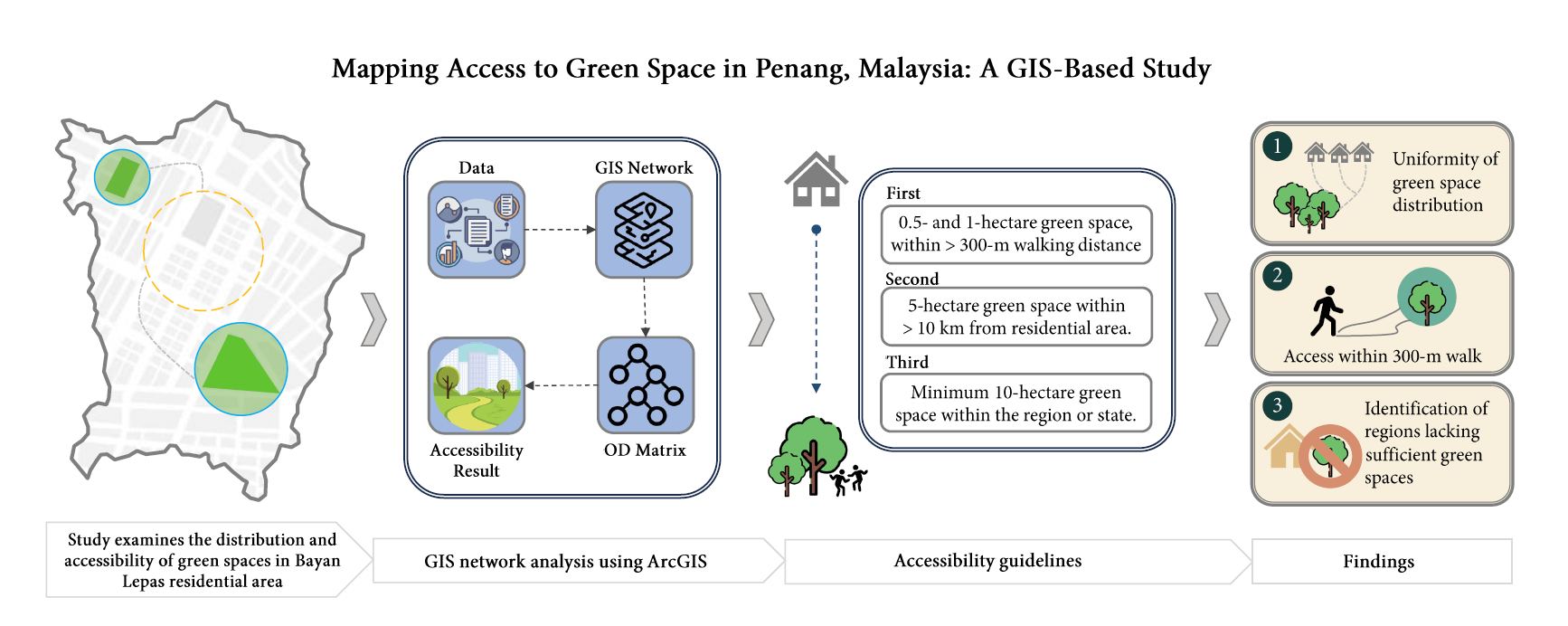
Mapping Access to Green Space in Penang, Malaysia: A GIS-Based Study
1 School of Housing, Building and Planning, Universiti Sains Malaysia, Minden, 11800, Penang, Malaysia
2 May Design Sdn Bhd, Cinta Sayang Resort, Persiaran Cinta Sayang, Sungai Petani, 08000, Kedah, Malaysia
* Corresponding Author: Massoomeh Hedayati Marzbali. Email:
(This article belongs to the Special Issue: Advancements in Geospatial Methods and Technologies for Sustainable Built Environment and Engineering)
Revue Internationale de Géomatique 2025, 34, 553-567. https://doi.org/10.32604/rig.2025.066073
Received 28 March 2025; Accepted 14 July 2025; Issue published 06 August 2025
 View Full Text
 Download PDF
Abstract
Urban green spaces play a crucial role in improving the well-being of city dwellers, offering recreational benefits that contribute to physical health. However, challenges remain in ensuring these spaces are distributed equitably and are accessible to all. This research examines the distribution and accessibility of green spaces in Bayan Lepas, Penang, Malaysia. The study focuses on evaluating three key factors: (1) the uniformity of green space distribution in the area, (2) the proportion of residents who can access green spaces within a 300-m walk, and (3) the identification of regions that lack sufficient green spaces, such as parks and recreational areas. To assess accessibility, the study uses a distance-based impedance method within a Geographic Information System (GIS) network analysis framework. Network distance rather than Euclidean distance is used to simulate actual walking paths along roads and pedestrian routes. ArcGIS software is employed to construct service areas and compute origin-destination cost paths between residential zones and green spaces of various sizes. The findings reveal that 82.32% of Bayan Lepas residents have access to green spaces ranging from 0.5 to 1 hectare within a 300-m walking distance. Additionally, 72.93% are served by green spaces of at least 5 hectares within a 10-km radius. At the regional scale, 100% of residents have access to green spaces of 10 hectares or more. These results provide valuable insights for urban planners and policymakers, highlighting the importance of enhancing spatial equity in green space distribution. The study offers a transferable methodology that can be adapted to other urban contexts with available GIS data and localized accessibility standards.Graphic Abstract
Keywords
Cite This Article
 Copyright © 2025 The Author(s). Published by Tech Science Press.
This work is licensed under a Creative Commons Attribution 4.0 International License , which permits unrestricted use, distribution, and reproduction in any medium, provided the original work is properly cited.
 Downloads
 Citation Tools