 Open Access
ISSN:1260-5875 (print)
ISSN:2116-7060 (online)
Publication Frequency:Continuously

Revue Internationale de Géomatique (RIG, International Journal of Geomatics) is an international interdisciplinary journal dedicated to the sciences of geographical information and spatial analysis. Since 1991, RIG has published original research articles in both French and English, promoting collaboration among researchers from geography, computer science, remote sensing, social sciences, environmental sciences, archaeology, and agronomy. The journal focuses on approaches, methods, and tools developed to analyse, model, represent, and solve spatial problems in geographical space. RIG welcomes both theoretical and application-oriented contributions related to geomatics, geospatial technologies, and spatial decision-making. RIG particularly encourages interdisciplinary research combining technological innovations with real-world spatial applications. The journal values studies that integrate computer science and geographical information sciences to address complex environmental, territorial, and societal challenges.
Emerging Source Citation Index (Web of Science): 2025 Impact Factor 2.0; dblp Computer Science Bibliography; EBSCO; J-Gate; SUDOC; EZB; OpenAIRE; Portico, etc.
 Open Access
ARTICLE
Revue Internationale de Géomatique, Vol.35, pp. 409-422, 2026, DOI:10.32604/rig.2026.083214 - 02 July 2026
(This article belongs to the Special Issue: Geospatial Techniques for Precision Agriculture and Water Resources Sustainability)
Abstract Groundwater is the primary buffer against water scarcity in rapidly urbanizing regions, yet its sustainable management is constrained by limited hydrogeological data. This study presents an integrated Geographic Information System (GIS) remote sensing framework strengthened with Artificial Intelligence (AI) to delineate groundwater potential zones (GWPZs) in the Islamabad Capital Territory. Six thematic layers—slope, drainage density, lithology, rainfall, land use/land cover (LULC), and the Normalized Difference Vegetation Index (NDVI)—were derived from SRTM DEM, Sentinel-2 imagery, geological maps, and climate records. Each layer was standardized, reclassified, and weighted using the Analytical Hierarchy Process (AHP). A complete pairwise… More >
Open Access
ARTICLE
Revue Internationale de Géomatique, Vol.35, pp. 373-407, 2026, DOI:10.32604/rig.2026.083180 - 18 June 2026
(This article belongs to the Special Issue: Application of Remote Sensing and GIS in Environmental Monitoring and Management, 2nd Edition)
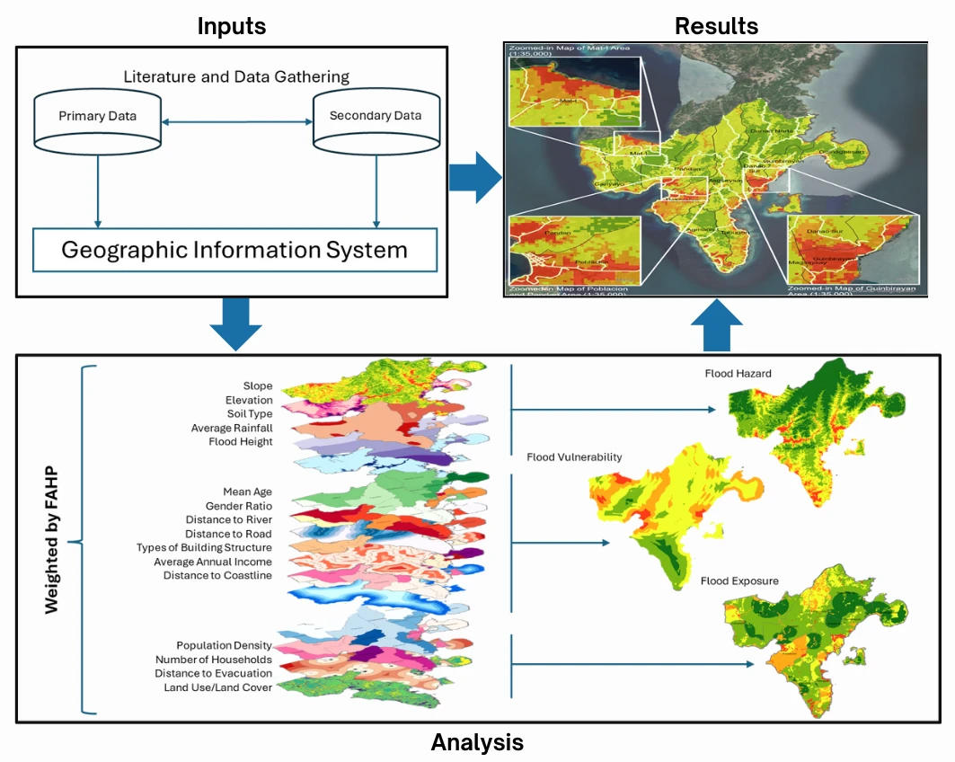
Abstract A landslide is the downslope movement of soil, rock, or debris driven by gravity, often triggered by natural or anthropogenic factors. The Philippines is highly susceptible to landslides due to its steep terrain, frequent typhoons, intense rainfall, and seismic activity, resulting in significant socioeconomic and environmental impacts. Despite increasing landslide occurrences in vulnerable coastal and mountainous municipalities in the Philippines, localized and integrated Geographic Information System (GIS)-based landslide risk assessments incorporating hazard, vulnerability, and exposure components remain limited in small island municipalities such as San Andres, Romblon. This study assesses landslide risk in the Municipality… More >
Open Access
ARTICLE
Revue Internationale de Géomatique, Vol.35, pp. 351-371, 2026, DOI:10.32604/rig.2026.083243 - 18 June 2026
Abstract Urban blue spaces are increasingly recognized as critical components of sustainable cities. However, a significant gap exists in understanding their role not just as recreational areas, but as functional mobility corridors, especially within urban fabric of Eastern Europe countries. This study addresses this gap by assessing the accessibility and integration potential of blue infrastructure within Bucharest, Romania. The novelty of the research lies in the development of the Blue Areas Accessibility Index (BAAI), using a GIS-based Multi-Criteria Analysis (MCA). Eight spatial parameters were standardized using Likert scale and weighted using the Analytic Hierarchy Process to… More >
Open Access
ARTICLE
Revue Internationale de Géomatique, Vol.35, pp. 333-349, 2026, DOI:10.32604/rig.2026.081503 - 11 June 2026
(This article belongs to the Special Issue: Resource and Environmental Information Modeling - 2nd Edition)
Abstract Soil degradation in Mediterranean agricultural systems is strongly conditioned by topography, water redistribution and solar exposure, factors that can be effectively studied using very high-resolution remote sensing. This study evaluates the potential of Unmanned Aerial Vehicle (UAV)-derived geomorphometry combined with machine learning techniques to analyse the spatial variability of the Normalized Difference Vegetation Index (NDVI) as a surface spectral response under post-harvest conditions in a Mediterranean cereal field affected by soil degradation and gully erosion, located near Casabermeja (Málaga, southern Spain). High-resolution RGB and multispectral UAV data were used to generate a Digital Terrain Model… More >
Open Access
ARTICLE
Revue Internationale de Géomatique, Vol.35, pp. 315-332, 2026, DOI:10.32604/rig.2026.084921 - 11 June 2026
(This article belongs to the Special Issue: Resource and Environmental Information Modeling - 2nd Edition)
Abstract Against the backdrop of rapid global urbanization, revealing the indirect ecological effects triggered by urban environmental restructuring and human management interventions carries early-warning significance for preventing cliff-like vegetation degradation driven by unchecked urban expansion. Existing studies predominantly rely on linear assumptions and neglect the temporal lags inherent in ecological responses, making it difficult to capture the long-run and short-run dynamics as well as potential nonlinear thresholds of indirect impacts. Using Nanjing as the study region, this research constructs a spatiotemporal panel dataset at 1 km × 1 km resolution based on multi-source remote sensing data… More >
Open Access
ARTICLE
Revue Internationale de Géomatique, Vol.35, pp. 291-313, 2026, DOI:10.32604/rig.2026.081197 - 05 June 2026
(This article belongs to the Special Issue: Application of Remote Sensing and GIS in Environmental Monitoring and Management)
Abstract Urban trees are a critical component of green infrastructure in tropical cities, yet city-scale evidence on tree health in Indonesia remains limited. This study assessed urban tree health in Medan City using the Forest Health Monitoring (FHM) protocol, Tree Level Index (TLI), GIS-based spatial analysis, and Normalized Difference Vegetation Index (NDVI) validation to support Eco Forest City planning. A total of 1184 trees, representing a 30% sample from 3947 inventoried trees across six sub-districts, were evaluated based on damage location, type, and severity. Average Nearest Neighbor (ANN) and Kernel Density Estimation (KDE) were applied to… More >
Open Access
ARTICLE
Revue Internationale de Géomatique, Vol.35, pp. 273-290, 2026, DOI:10.32604/rig.2026.080586 - 21 May 2026
(This article belongs to the Special Issue: Resource and Environmental Information Modeling - 2nd Edition)
Abstract Groundwater is an essential resource contributing substantially to the annual total water supply. It enables agricultural irrigation and provides billions of people with their main source of drinking water. But overuse of groundwater has decreased its supply and, in certain places, resulted in soil subsidence. In the complex hydrogeological terrain of Timergara, traditional groundwater exploration is challenging and costly, requiring more efficient mapping approaches. Groundwater recharge potential zones must be assessed in order to guarantee sustainable groundwater management. This study uses Remote Sensing (RS) and Geographic Information System (GIS) methodologies to evaluate groundwater potential sites… More >
Open Access
ARTICLE
Revue Internationale de Géomatique, Vol.35, pp. 249-272, 2026, DOI:10.32604/rig.2026.076139 - 21 May 2026
(This article belongs to the Special Issue: Time Series Remote Sensing Data Processing and Applications)
Abstract This study aimed to evaluate the potential of Sentinel-3 as an alternative to Moderate Resolution Imaging Spectroradiometer (MODIS) for generating high spatiotemporal resolution land surface temperature (LST) data. The Enhanced Spatial and Temporal Adaptive Reflectance Fusion Model (ESTARFM) and the machine-learning-based Extreme Gradient Boosting (XGBoost) algorithm were independently assessed for fusing MODIS–Landsat and Sentinel-3–Landsat data. This comparison enabled the evaluation of each model’s capability to reconstruct spatiotemporal LST variations and assess the performance of the two sensors in the fusion process. The results showed that XGBoost outperformed ESTARFM in capturing complex and heterogeneous LST patterns,… More >
Open Access
REVIEW
Revue Internationale de Géomatique, Vol.35, pp. 205-247, 2026, DOI:10.32604/rig.2026.078160 - 19 May 2026
(This article belongs to the Special Issue: Application of Remote Sensing and GIS in Environmental Monitoring and Management)
Abstract Surface water quality is a sensitive global environmental issue, as it is important for long-term economic development and environmental sustainability. Due to population growth, urbanization, and the effects of climate change, the degradation of surface water quality cannot be avoided. Therefore, a more accurate, continuous, and operational monitoring of water quality is highly significant. This study aims to systematically review and synthesize existing literature on the technological advancement, challenges, and future directions of Remote Sensing (RS) and Geographic Information System (GIS) techniques in surface water quality monitoring. Following PRISMA guidelines, a structured literature search of… More >
Open Access
ARTICLE
Revue Internationale de Géomatique, Vol.35, pp. 179-203, 2026, DOI:10.32604/rig.2026.079622 - 19 May 2026
(This article belongs to the Special Issue: Application of Remote Sensing and GIS in Environmental Monitoring and Management)
Abstract This study addresses the challenges of traditional forest inventory methods for Norway spruce (Picea abies (L.) Karst.) by leveraging Sentinel-2 multispectral data to derive critical forest parameters, including biomass, stand density, and site class. Remote sensing offers scalable solutions for large-scale monitoring, yet topographic variability and spectral saturation limit the use of empirical vegetation index (VI)-based approaches. The methodology analyzed 43 Norway spruce subcompartments in Bulgaria’s Parangalitsa Reserve using a 2017 Sentinel-2 L2A scene, calculating 24 vegetation indices (e.g., Canopy Chlorophyll Content Index (CCCI), Forest Cover Index (FCI1/FCI2), Normalized Difference Water Index (NDWI) and three biophysical… More >
Open Access
ARTICLE
Revue Internationale de Géomatique, Vol.35, pp. 161-177, 2026, DOI:10.32604/rig.2026.079702 - 30 April 2026
Abstract Water scarcity is a significant challenge in arid and semi-arid countries, underscoring the importance of thoroughly studying groundwater resources. Egypt, especially in the Darb El-Arbaein region of the southern Western Desert, faces various water challenges and relies primarily on groundwater from the Nubian Sandstone aquifer. Proper management of this groundwater is essential for addressing these challenges. The study examines the spatial and temporal variations in the hydrogeochemistry of the Nubian sandstone aquifer. Data collected from the aquifer’s monitoring network include key hydrogeochemical parameters, such as total dissolved solid (TDS) and piezometric heads, over different periods.… More >
Open Access
ARTICLE
Revue Internationale de Géomatique, Vol.35, pp. 131-160, 2026, DOI:10.32604/rig.2026.076765 - 19 March 2026
(This article belongs to the Special Issue: Resource and Environmental Information Modeling)
Abstract Extreme climate and weather conditions pose significant risks to public health, economic stability, and the quality of both built and natural environments. This study evaluates projected changes in climate extreme events over the Omo-Gibe River Basin (OGRB), Ethiopia, using 12 CMIP6 Global Climate Models (GCMs). Additionally, rainfall-runoff simulations were assessed using the HEC-HMS hydrological model. Due to the region’s susceptibility to extreme hydro-meteorological events like floods and droughts, gaining insight into future climate variability is essential for managing water resources effectively and reducing disaster risks. This analysis examines extreme precipitation and temperature indices under two… More >
Open Access
ARTICLE
Revue Internationale de Géomatique, Vol.35, pp. 121-130, 2026, DOI:10.32604/rig.2026.075844 - 04 March 2026
Abstract Moon-based Synthetic Aperture Radar (SAR) is particularly suitable for monitoring polar regions because of its consistent and continuous imaging. It has promising applications in the observation of sea ice by capturing rapid freeze-thaw cycles in the Arctic and Antarctic. However, the long synthetic aperture time inherent in Moon-based SAR may lead to image defocusing due to water fluctuations. Additionally, large incidence angles during observations in polar regions can result in weak backscatter from sea ice, thereby affecting the signal-to-noise ratio and ice–water discrimination. In this study, a ground-based experiment was conducted to evaluate the impact More >
Open Access
ARTICLE
Revue Internationale de Géomatique, Vol.35, pp. 101-120, 2026, DOI:10.32604/rig.2026.072359 - 24 February 2026
(This article belongs to the Special Issue: Advancements in Geospatial Methods and Technologies for Sustainable Built Environment and Engineering)
Abstract The integration of Light Detection and Ranging (LiDAR) technology into consumer electronics like smartphones has created new opportunities for the use of three-dimensional (3D) modelling, especially in the domains of infrastructure inspection and civil engineering. This paper presents the accuracy of a 3D bridge model generated using a smartphone LiDAR application in comparison with conventional surveying methods. In this study, LiDAR data were captured using an iPhone 13 Pro and processed to generate 3D models. The accuracy of the generated model was then validated against reference data obtained from a tacheometry survey, which served as… More >
Open Access
ARTICLE
Revue Internationale de Géomatique, Vol.35, pp. 79-100, 2026, DOI:10.32604/rig.2026.074969 - 05 February 2026
(This article belongs to the Special Issue: Geospatial Techniques for Precision Agriculture and Water Resources Sustainability)
Abstract The assessment of groundwater quality is crucial for ensuring its safe and sustainable use for domestic and agricultural purposes. The Kurukshetra district in the Indian state of Haryana relies heavily on groundwater to meet household and agricultural needs. Sustainable groundwater management must be assessed in terms of suitability for domestic and agricultural needs in a region. The current study analyzed pre-monsoon geochemical data from groundwater samples in the study area for 1991, 2000, 2010, and 2020. A Geographic Information System (GIS) was used to create spatial distribution maps for hydrogen ion concentration, total hardness, total… More >
Open Access
ARTICLE
Revue Internationale de Géomatique, Vol.35, pp. 53-78, 2026, DOI:10.32604/rig.2026.071069 - 05 February 2026
(This article belongs to the Special Issue: Innovative Applications and Developments in Geomatics Technology)
Abstract The expansion of transportation networks, including railways and ports, has been a major force driving urban growth, mobility, and socio-economic transformations since the Industrial Revolution. This study utilizes Historical Geographic Information Systems to examine the global evolution of transportation infrastructure, focusing on railways and ports, from 1880 to 2020. The dataset enables a multidimensional analysis of how transportation systems have shaped cities, influenced regional development, and helped to make possible sustainability efforts. By offering insights into transport accessibility, land-use changes, and economic connectivity, the study provides a robust empirical foundation for understanding long-term infrastructure dynamics. More >
Open Access
ARTICLE
Revue Internationale de Géomatique, Vol.35, pp. 31-51, 2026, DOI:10.32604/rig.2026.075081 - 05 February 2026
Abstract Climate classification systems are essential tools for analyzing regional climatic behavior, assessing long-term aridity patterns, and evaluating the impacts of climate change on water resources and ecosystem resilience. This study introduces a new Climate Classification Method based on uniform and unitless variables, referred to as the U2 Climate Classification (U2CC). The proposed U2 Index was designed to overcome structural limitations of the classical De Martonne (1942) and Erinç (1949) indices, which rely on raw precipitation–temperature ratios and are sensitive to extreme values, particularly subzero temperatures. The U2 methodology consisted of two key steps: (i) normalization… More >
Open Access
ARTICLE
Revue Internationale de Géomatique, Vol.35, pp. 13-30, 2026, DOI:10.32604/rig.2026.068019 - 05 February 2026
Abstract Rainfall data from four weather stations, quite far from each other, but located in the Zambezian phytogeographic region, were analysed for the research for indices of climate change. Two variables, rainfall and the annual number of rainy days, were considered. The rainfall data examined are 114 years for Luanda (1901–2014), 106 years for Lubumbashi (1916–2021), respectively, 54 and 41 years for Huambo (1961–2014) and Boma (1981–2021); 100 years (1921–2021) for the annual number of rainy days for only the Lubumbashi weather station. The results were a widespread decline in rainfall at all weather stations. Despite… More >
Open Access
ARTICLE
Revue Internationale de Géomatique, Vol.35, pp. 1-11, 2026, DOI:10.32604/rig.2026.070991 - 19 January 2026
(This article belongs to the Special Issue: Innovative Applications and Developments in Geomatics Technology)
Abstract The use of Unmanned Aerial Vehicles (UAVs) in photogrammetry has grown rapidly due to enhanced flight stability, high-resolution imaging, and advanced Structure from Motion (SfM) algorithms. This study investigates the potential of UAVs as a cost-effective alternative to Terrestrial Laser Scanners (TLS) for 3D building reconstruction. A 3D model of Bangunan Sarjana was generated in Agisoft Metashape Professional v.2.0.2 using 492 aerial images captured at flying altitudes of 40, 50, and 60 m. Ground control points were established using GNSS (RTK-VRS), and Total Station measurements were employed for accuracy validation. The results indicate that the 60 More >

 Submit a Paper
 Propose a Special lssue