
 Submit a Paper
 Propose a Special lssue
 Open Access
ARTICLE

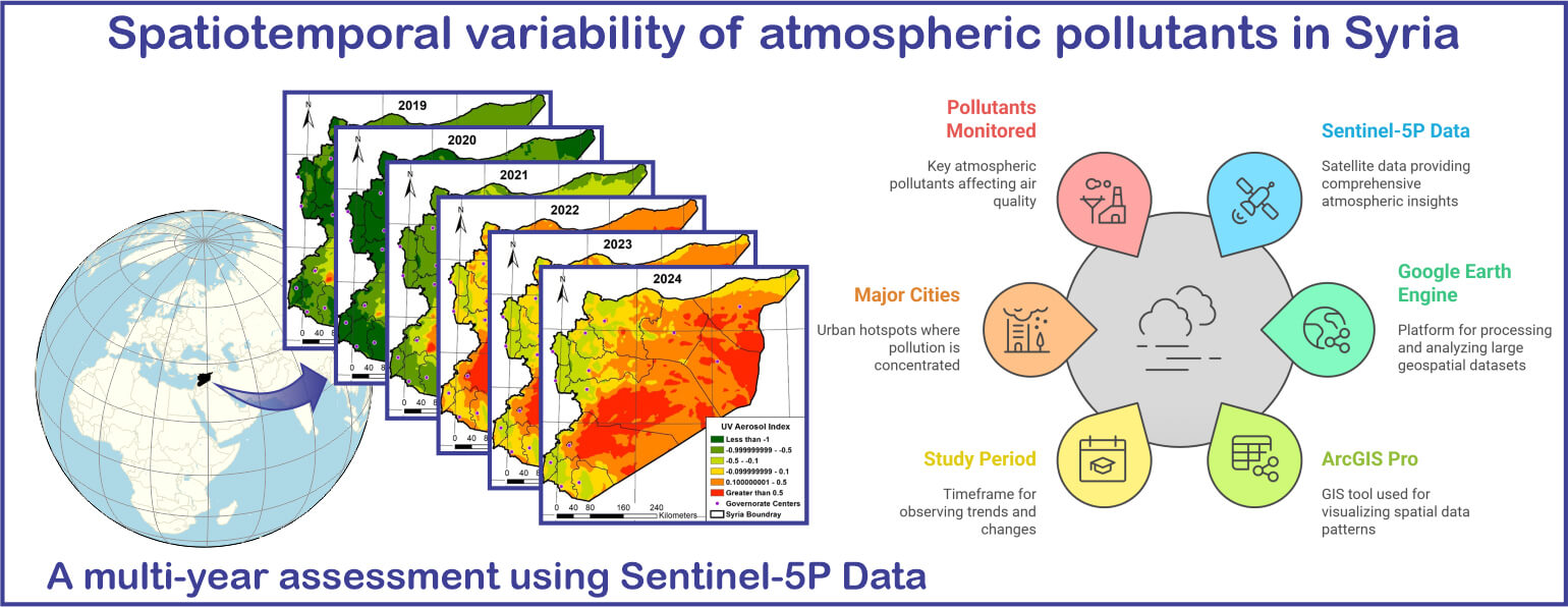
Spatiotemporal Variability of Atmospheric Pollutants in Syria: A Multi-Year Assessment Using Sentinel-5P Data
1 Department of Topography, Faculty of Civil Engineering, University of Aleppo, Aleppo, 12212, Syria
2 Laboratory of Architecture, Cities and Environment, Faculty of Civil Engineering and Architecture, Department of Hydraulic, Hassiba Benbouali University of Chlef, B.P. 78C, Ouled Fares, Chlef, 02180, Algeria
3 Faculty of Science, University of Technology Sydney, Sydney, NSW 2007, Australia
4 Department of Geography, Faculty of Arts and Humanities, Damascus University, Damascus, 1193, Syria
5 Department of Geography, Faculty of Arts and Humanities, Tartous University, Tartous, 96510, Syria
6 Department of Mathematics and Computer Science, Faculty of Material Sciences, Mathematics and Computer Science, University Ahmed Draia of Adrar, Adrar, 01000, Algeria
7 Energies and Materials Research Laboratory, Faculty of Sciences and Technology, University of Tamanghasset, Tamanghasset, 11000, Algeria
8 Department of Civil and Environmental Engineering, Federal University of Paraíba, João Pessoa, 58051-900, Paraíba, Brazil
9 Stokes School of Marine and Environmental Sciences, University of South Alabama, Mobile, AL 36688, USA
* Corresponding Author: Bilel Zerouali. Email:
(This article belongs to the Special Issue: Applications of GNSS Remote Sensing)
Revue Internationale de Géomatique 2025, 34, 669-689. https://doi.org/10.32604/rig.2025.067137
Received 25 April 2025; Accepted 29 July 2025; Issue published 19 August 2025
 View Full Text
 Download PDF
Abstract
This study investigates the spatial and temporal dynamics of key air pollutants—nitrogen dioxide (NO2), carbon monoxide (CO), methane (CH4), formaldehyde (HCHO), and the ultraviolet aerosol index (UVAI)—over the period 2019–2024. Utilizing high-resolution remote sensing data from the Sentinel-5 Precursor satellite and its TROPOspheric Monitoring Instrument (TROPOMI) processed via Google Earth Engine (GEE), pollutant concentrations were analyzed, with spatial visualizations produced using ArcGIS Pro. The results reveal that urban and industrial hotspots—notably in Damascus, Aleppo, Homs, and Hama—exhibit elevated NO2 and CO levels, strongly correlated with population density, traffic, and industrial emissions. Temporal trends indicate significant pollutant fluctuations linked to external factors such as economic activities and regulatory measures. Methane concentrations have shown a steady increase, driven by intensified oil refining, biomass burning, and agricultural practices. Formaldehyde levels initially declined—due to reduced industrial activity—before experiencing a moderate rebound, though remaining below 2019 levels overall. The UV aerosol index demonstrated marked variability, predominantly influenced by wind-driven dust transport, desert dust storms, and localized anthropogenic emissions. These findings underscore the intricate interplay between economic dynamics and environmental processes, highlighting the critical need for robust air quality management strategies.Graphic Abstract
Keywords
Cite This Article
 Copyright © 2025 The Author(s). Published by Tech Science Press.
This work is licensed under a Creative Commons Attribution 4.0 International License , which permits unrestricted use, distribution, and reproduction in any medium, provided the original work is properly cited.
 Downloads
 Citation Tools