
 Submit a Paper
 Propose a Special lssue
 Open Access
ARTICLE

Development of Pandemic Monitoring System Based on Constellation of Nanosatellites
Department of Science and Technology, College of Ranyah, Taif University, P.O. Box 11099, Taif, 21944, Saudi Arabia
* Corresponding Author: Omar Ben Bahri. Email:
Computer Systems Science and Engineering 2023, 46(1), 1249-1263. https://doi.org/10.32604/csse.2023.032677
Received 26 May 2022; Accepted 27 June 2022; Issue published 20 January 2023
 View Full Text
 Download PDF
Abstract
Covid-19 is a global crisis and the greatest challenge we have faced. It affects people in different ways. Most infected people develop a mild to moderate form of the disease and recover without hospitalization. This presents a problem in spreading the pandemic with unintentionally manner. Thus, this paper provides a new technique for COVID-19 monitoring remotely and in wide range. The system is based on satellite technology that provides a pivotal solution for wireless monitoring. This mission requires a data collection technique which can be based on drones’ technology. Therefore, the main objective of our proposal is to develop a mission architecture around satellite technology in order to collect information in wide range, mostly, in areas suffer network coverage. A communication method was developed around a constellation of nanosatellites to cover Saudi Arabia region which is the area of interest in this paper. The new proposed architecture provided an efficient monitoring application discussing the gaps related to thermal imaging data. It reached 15.8 min as mean duration of visibility for the desired area. In total, the system can reach a coverage of 5.8 h/day, allowing to send about 21870 thermal images.Keywords
The COVID-19 pandemic is much more than a health crisis. It is also an unprecedented socio-economic crisis putting pressure on each of the countries it affects. It has devastating social, economic, and political impacts that will leave deep scars. Every day, jobs and income are lost, with no way of knowing when there will be a return to “normalcy”. Small island nations, heavily dependent on tourism, face empty hotels and deserted beaches. The International Labor Organization estimates that 195 million jobs could be lost. The World Bank projects a drop of $ 110 billion in remittances this year, which could mean that 800 million people will not be able to meet their basic needs [1].
This critical fact led to develop the appropriate analysis technique to detect infected peoples in order to reduce the spread of the pandemic. In this context, many tests are developed such as Polymerase Chain Reaction (PCR), which is considered as the best method for the detection of corona virus by rapid detection, specificity, and high sensitivity [2]. Another method is by real-time reverse transcriptase-PCR (RT-PCR) which has proven to be simple and specific qualitative assay [3,4]. In addition, antibody tests can inform if a person has been infected in the past, even if they have not had symptoms. It is called serological tests and usually performed on a blood sample. These tests detect antibodies produced in response to an infection. In most people, antibodies start to appear after a few days or weeks and can indicate whether a person has already been infected. These tests cannot be used to diagnose COVID-19 in the early stages of infection or illness, but they can tell if a person has been sick [5].
Unfortunately, these traditional methods are costly and can present an important issue with the risk of diagnosing the maximum infected cases. Many people prefer to visit medical centers in case of serious symptoms that need expert intervention. This problem limits the possibility of counting cases and therefore, the spread of the pandemic.
All these reasons led to developing a monitoring technique to detect the maximum infected cases. Remote monitoring presents an interesting solution for wireless health care. A.R. Watson, et, al. review the efficiency of remote monitoring including different techniques such as telemedicine and 5G technology [6]. Annis, et al. provide methods for sharing concerns and symptoms based on remote monitoring solution around the GetWell Loop application [7]. This method presents a pivotal solution to minimize COVID-19 exposure. In addition, several applications can help to confine infected cases, such as the application based on text message to confirm or suspect COVID-19 at home [8].
Unfortunately, these methods create a problem in detecting the maximum number of cases that depend on people awareness. Deficiencies in implementation are among these problems, mostly, in cases with weak symptoms. Thus, new technology offers many platforms to overcome these problems of real-time diagnosis and monitoring.
Among technologies, the use of drones provides several benefits for a permanent monitoring coverage. Chamola, et al. review the impact of drones in managing the rapid spread of COVID-19. In this context many systems were developed in detecting corona virus remotely such as thermal image processing using drone [9]. It is showed that a wide area can be covered to identify patient within a period of 2 Km within 10 min approximately [10]. In fact, the drone based on thermal imaging was designed for capturing the temperature of people in crowds and can be used in the early diagnosis phase. This type of drone can be combined with Virtual Reality as a wearable device to identify people with high fevers [11]. In addition, this method can send alert to health officer when detecting high temperature, including, GPS location, captured thermal and optical images, and live video streaming [12].
In fact, many satellite applications focus on remote sensing including a cost sensor to accomplish their objective. This presents a gap, especially, for emerging countries. Thus, drone technology for example can present a promising solution for low-cost application [13]. Besides, extending the use of a drone from mission-centric, science, or defense sector to social health is of critical importance especially for dealing with COVID-19 epidemic. This work supports the argument that drones have influenced health quality and relief measures in real life at a significant level [14]. Drones can prove to be of great assistance in all these areas at varying levels [15,16].
Indeed, most of these ideas need internet to share real-time monitoring data for a rapid intervention. However, internet coverage presents a real gap in such areas like Middle East and North Africa (MENA) regions. Often, most of these regions are often without infrastructure in all areas. Many challenges occur when thinking to apply for example 4G or 5G technologies for sharing data. Thus, it seems wise to develop a new wireless system to overcome this issue by using the small satellite technology. It benefits the data transmission in any desired area. A software defined radio module is among systems that can be integrated on drones to benefit from the use of small satellite technology for near real-time transmission. A transmission method was analyzed in this work to provide the adequate techniques to transmit data. This led to conceive the appropriate architecture of satellite constellation to cover Saudi Arabia which represents the area of interest in this paper, as it suffers internet coverage in some areas. The novel constellation architecture was developed and simulated that can provide a near real-time transmission, and therefore, increasingly improve the monitoring techniques in remote areas. The intervals of coverage duration, revisit time and total coverage of the desired area were the main parameters of interest to develop the adequate constellation architecture which is the main objective of this paper.
The proposal’s main objective is to provide a new wireless technique for COVID-19 monitoring in order to limit its rapid spread. The system aims to improve the transmission method of the data collected using drones. The nano-satellite technology presents a promising solution to fill the gap of network coverage in all areas, especially for Saudi Arabia region. The proposed system is presented in Fig. 1.
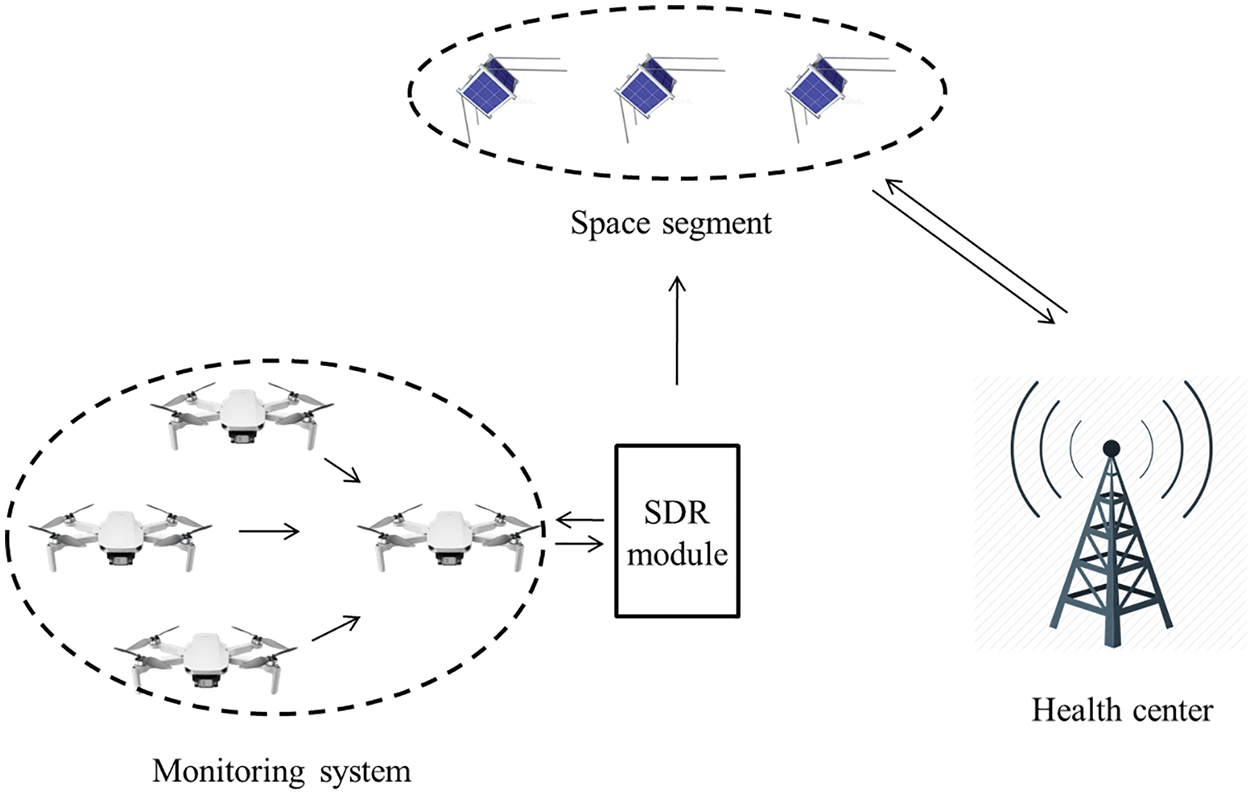
Figure 1: Data transmission architecture
The system encompasses 4 main links of communication:
• Inter drones’ link.
• Drone-space segment link through the Software Defined Radio (SDR) module.
• Inter satellites link.
• Space segment-health center link
This architecture provides a reliable communication system to transmit data in remote areas that suffer internet coverage.
In order to enhance the communication of two points that are distant from each other, and which located in regions where it is impossible to have a fixed infrastructure, satellite communications are the best solution. Satellites can also ensure communication between the ground station and the drone. Therefore, for multi-drone systems, each aircraft can communicate with the ground station through a satellite. Thus, communications between drones can also be performed in the same way. However, this approach has some weak points such as the high transmission latency and the cost of satellite launching. In addition, the drones as well as the control station must be in line with the sight of the satellite. Indeed, for certain missions, trees or buildings can be obstacles against the signal exchanged between the drones and their satellite.
This led to propose a drones’ networks as sensors’ node system, to limit the conflict of communication. In addition, the proposed system is based on thermal as a reliable solution to detect infected peoples. In fact, this method presents challenges in term of accuracy that led to develop filtering system to fill this gap in such application [16]. In fact, previous work based thermal imaging camera proved its efficiency to detect a reliable human temperature [17]. This work was developed a technique to perform body diagnosis to detect the elevated temperature in order to fight the spreading of infection. It has shown a good detection accuracy.
Thus, development in this field led to the birth of new techniques to improve data accuracy of thermal imaging. Among, DJI enterprise was succeeded to develop a reliable drone (DJI Mavic 2 Enterprise DUAL) to detect temperature using 2 cameras [18]. This presents the adequate method to accomplish the goal of the proposed system. It can be integrated to the entire architecture. The specifications of this system are summarized in Table 1.
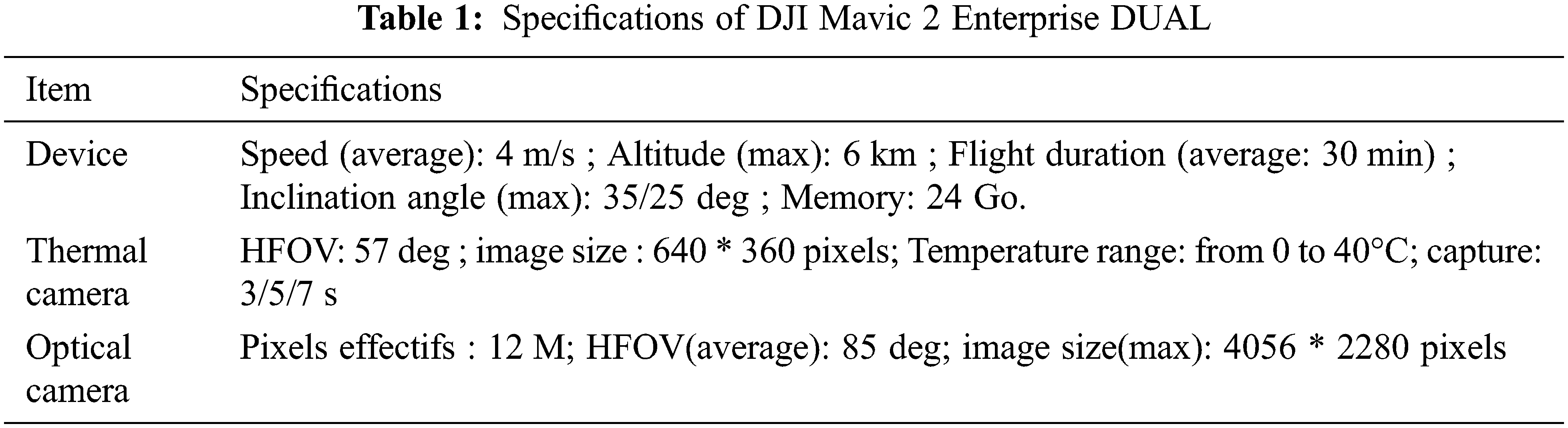
We can deduce from the table that the drone can cover approximately 7 km in one flight mission. In addition, the integrated thermal camera can capture approximately 360 images, considering 1 image/5 s. The image file size equals about 0.69 Mo, reaching a total of 248, 4 Mo in total. The big number of images led us to think about the transmission method to the required data. The system therefore can transmit the necessary data to the satellite in order to collect the maximum number of infected peoples. The drones can be adjusted to send only fever data.
The first step in designing a space mission is to define the mission objectives, then choose the appropriate orbit for that mission and then design a satellite that meets the requirements and objectives of the mission in order to launch a suitable communication architecture design. It is a network of satellites and earth stations linked together with communication links. Indeed, the communication links allow a satellite system to operate by performing the monitoring, control, telemetry and sending of mission data.
Indeed, users will be able to assign different priorities to the selection criteria of communication architecture.
In fact, the idea requires a full coverage of a desired area. Thus, a network of drones is needed that act as master-slave system. Each drone collects thermal data of people in crowds and sends it to the master drone. Therefore, the master collects all data and transmits to the health center through the nanosatellites’ constellation. The system acts as a sensors’ node that communicate with the master to collect data through a wide range connection which can be based on Zigbee, Wi-Fi or LTE protocols in such examples [19]. These previous works aimed to develop network of drones to collect the needed data of the zone of interest.
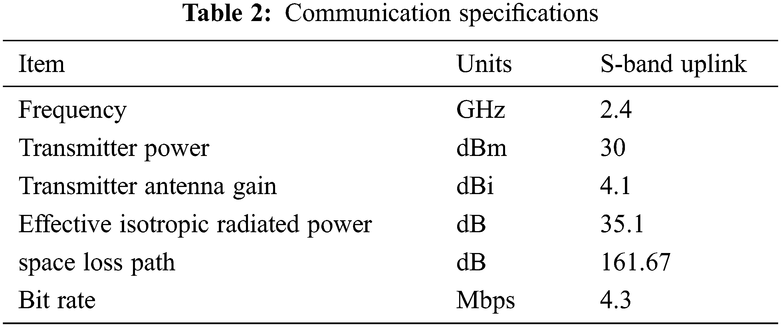
Several works focus on developing methods to extract data for coronavirus monitoring [9,10] using drones. The challenge is how to develop a real time monitoring system especially in zone where internet network presents a major issue. Here, nanosatellite technology presents a promising solution to fill this gap. Thus, the proposed system aim is to integrate a novel communication technique to the previous monitoring systems for a real-time sharing data. It is based on the integration of SDR module as a communication system. The first step is carried out for converting collected data to the suitable protocol of communication which deals with SDR module. It acts as a bridge of communication. This technique was developed and proved its efficiency adapting any received signal to the appropriate protocol of communication [20]. According to the transmission requirements, the VHF protocol is selected in order to transmit the collected data to the nanosatellite constellation. Table 2 illustrates the link budget and the antenna’s specifications.
Here, the novelty resides on the use of Communication Bridge in order to benefit from transmitting data in a wide range.
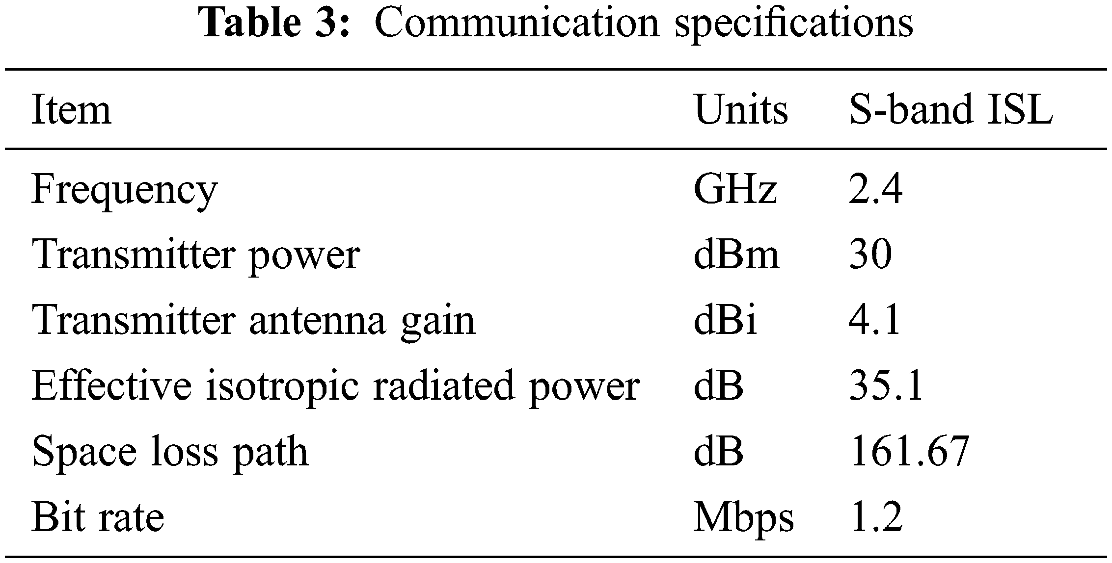
In order to cover the desired area for quasi-permanent time, a constellation of nanosatellites is needed to accomplish this goal. Thus, the adequate communication system was developed for inter satellites link (ISL), including, antenna and link budgets. Indeed, patch antenna proves its efficiency in small satellite applications benefiting its small size [21,22]. Therefore, the link budget of the communication needed inter the proposed constellation proposed is illustrated in Table 3.
4.4 Space Segment-Health Center Link
In fact, the ground station is intended for communication with one or more space stations or with one or more ground stations via one or more satellites [23,24].
The ground station mainly comprises a transmission system whose complexity depends on the number of satellites and the different carrier frequencies simultaneously processed by the earth station, a reception system which also depends on the number of frequencies and satellites managed by the ground station , an antenna which is usually a single antenna for transmitting and receiving data, a tracking system to adjust the antenna to the proper position in order to produce ideal communication with the satellite, also it includes terrestrial interface equipment.
Indeed, the earth station must control the satellites and their payloads, monitor their condition, track and determine the attitude and orbital position of the satellites.
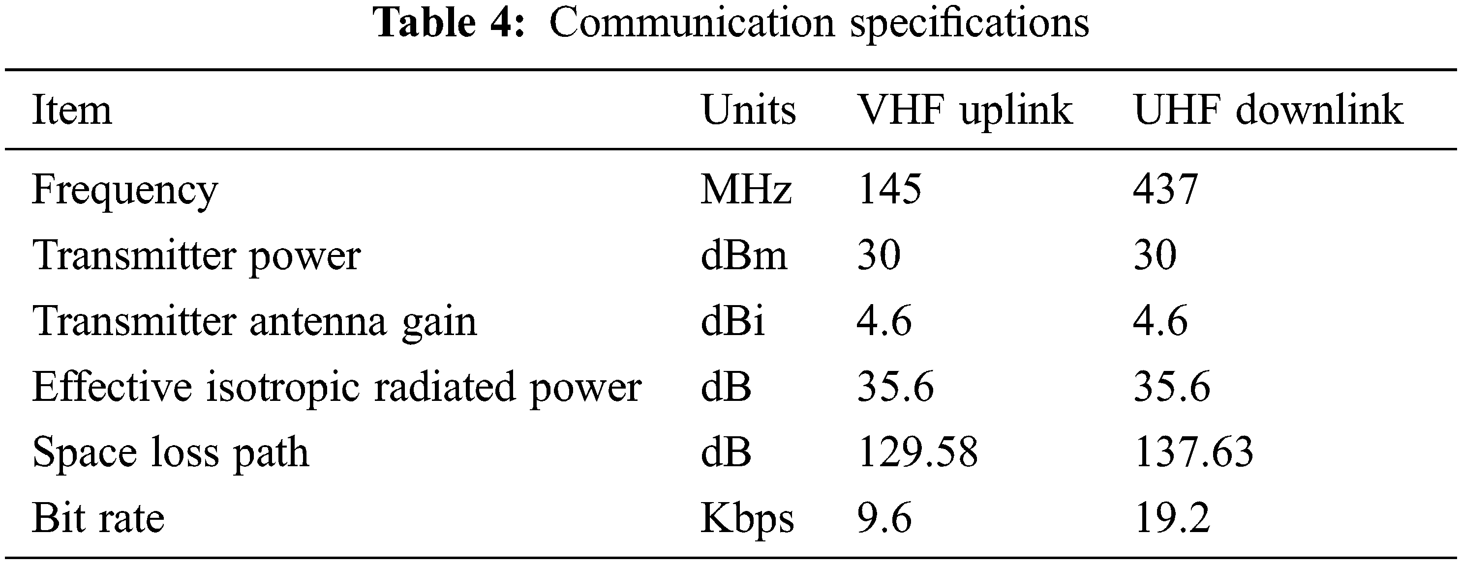
Thus, the link between the nanosatellites constellation and the ground station is composed by two frequency bands. The VHF band will be dedicated for uplink commands, while the UHF band will be dedicated for downlink. The data after being received based on UHF frequency, it will be distributed to the health center through Internet. Table 4 summarizes the link budgets of VHF/UHF bands.
5 Satellite Constellation Conception
The main idea of this proposal is to limit the rapid spread of corona virus using a new communication method for remote area, especially for Saudi Arabia region. The nanosatellite technology is proposed to fill the gap of network coverage. In fact, nanosatellites provide many benefits in space domain, declining the cost of satellite missions [25], such as the launch vehicles [26]. This increases the use of nanosatellites in the last two decades [27], including for example, the monitoring applications [28,29].
The system aims to send the collected data from the master drone to the satellite during visit. Thus, the main objective of this paper proposal is to develop the reliable satellite architecture able to cover the desired area benefiting a new technique for sharing data in near real-time. Table 5 presents the mean duration of visit for one satellite in Low Earth Orbit (LEO).
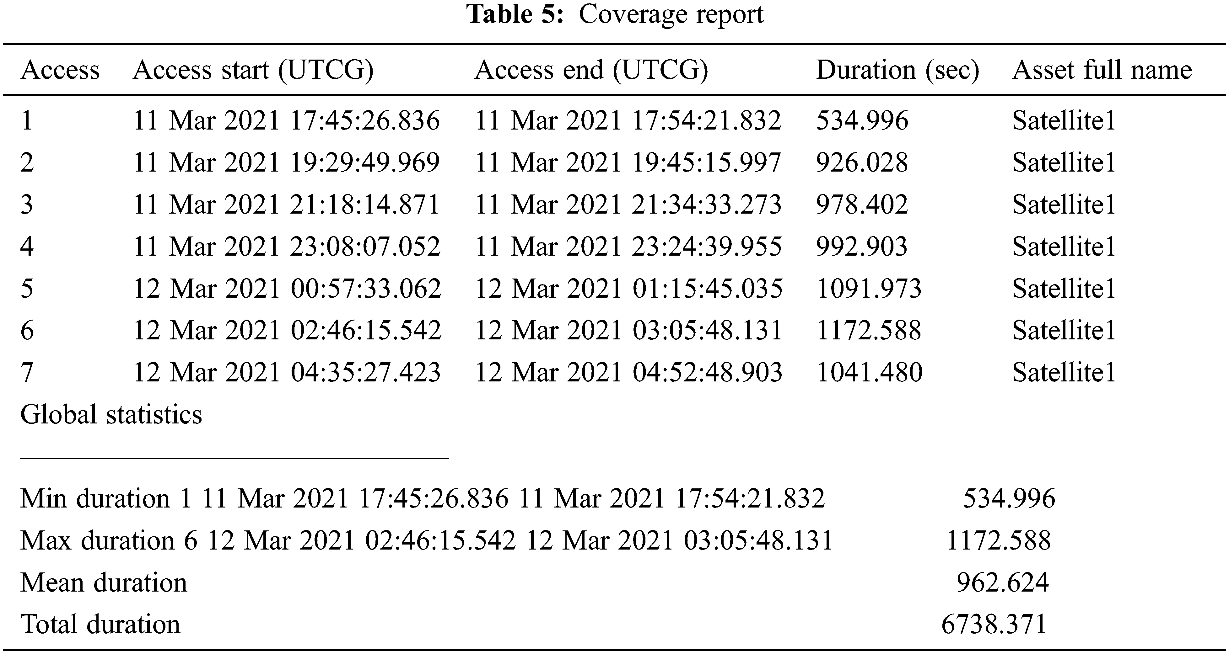
During one satellite’s visit, the average data that can be transferred is about 18.482 Mb, for a total of 129.376 Mb for all the day. Thus, the patients’ detection can be increased by integrating a constellation of nanosatellites in the entire mission. Satellite constellation method was proposed because of its large benefits [30].
After specifying the need including the area of application, expected performance and budget, we can look at the design phase of the constellation. This phase concerns the dimensioning of the constellation (number of needed satellites) and the positioning of the satellites. It is at the heart of the problem in which we are interested since it will condition the performance of the constellation that we are trying to optimize.
The parameters whose value we want to determine in order to optimize the constellation performance are on the one hand the number of satellites that must be used to solve the problem and on the other hand the value of the orbital parameters that define each of the satellites. Note that the number of unknowns varies during the optimization process, which imposes a certain number of constraints on the search techniques to be used. For example, the increase in the number of unknowns (through the increase in the number of satellites) implies a discontinuity in the evaluation function. Any algorithm needing a regularity property of the criterion cannot be implemented for the resolution of the global problem.
Furthermore, the number of parameters defining a satellite (6) generates a large search space. There are in fact 6n variables for n satellites [31].
5.1 Constellation Architecture
This phase defines the performance of the constellation by positioning the satellites around the earth. The variables of our optimization problem are on the one part the number of satellites that we consider as unknown and on the other part the position of each of them. By fixing the number of satellites we can eliminate an obstacle for the optimization problem. In fact, this system was proposed to send serious condition to the satellite. Thus, a constellation of three nanosatellites is sufficient to accomplish the mission’s goal benefiting the low-cost of the system. We will then describe the methods for choosing the adequate positioning of the satellites.
In fact, six orbital parameters define the position of satellite; The semi-major axis (a), the eccentricity (e), the inclination (i), the longitude of the ascending node (Ω), the argument of the perigee (ω) and the position of the object in its orbit (TA: True Anomaly). Two of these parameters; e and a define the trajectory in a plane, three others; i, Ω and ω define the orientation of the plane in space and the last; TA defines the position of the object. Fig. 2 presents theses parameters.
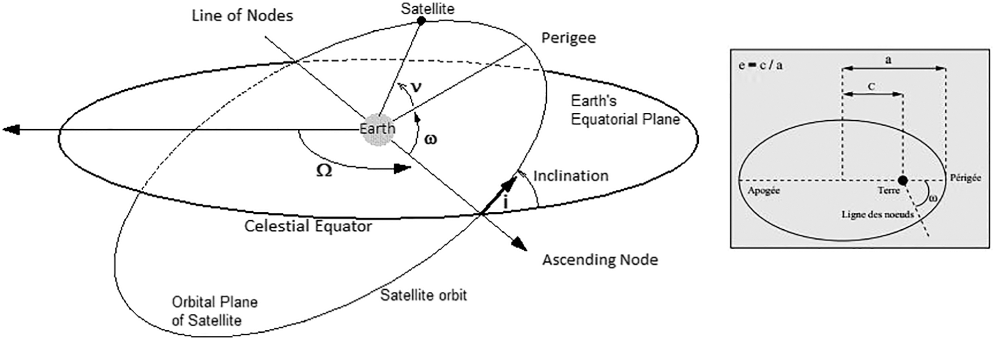
Figure 2: Orbital parameters
Once the structure of the constellation has been determined, it is necessary to determine the optimal way to put each satellite into its operational orbit: this is the stationing phase. The challenges of this phase are on the one hand the reduction of costs and on the other hand the reduction of the time to station.
• The parameter a is directly related to the duration of revolution of a satellite around its orbit which is illustrated by Eq. (1).
Were μ is the gravitational constant of the earth.
Thus, an increase in a causes an increase in the period of revolution T.
• The parameter e has no influence on T, but if for e = 0, the satellite has a constant speed with respect to a point located on earth; this is no longer the case for an elliptical orbit. When the satellite is near perigee, it has a faster speed than when it is near the apogee.
• The i value is used to calculate the latitudes that the satellite can fly over. More i is increases, more the width of the accessible latitude band increases.
• The parameter ω makes it possible to take advantage of the influence of e on the orbit path. We can for example position the passage of the satellite by its apogee when it flies over an area of interest.
• If the previous parameters have an influence on the behavior of the satellite within its orbit, the parameter Ω only allows it to rotate around the earth.
• The influence of parameter TA on the behavior of the satellite is of the same order as that of Ω since the position of the satellite in its orbit is fixed here.
Reducing costs from single launchers used to mean minimizing the number of satellites. With the advent of multiple launchers and large constellations this is no longer the case, and the deployment requires the development of real strategies.
The variables of these strategies, true optimization processes, are the launch dates, the type of launcher used and the duration of the satellite drift. In addition, depending on the launch pad, the launcher can only access certain inclination ranges. Finally, the satellite is not placed directly in its operational orbit. It passes through an intermediate orbit and through the play of drifts and thrusts, the satellite reaches its operational orbit after a certain time.
The cost of stationing is induced by the choice of launchers used (number of launches in total) and by the propellant consumption of the satellites for stationing. Consequently, the restriction of the number of orbits (inclination, altitude) makes it possible to put in place packet launch strategies which reduce both costs and deployment times. This complex sub-problem is moreover critical and a constellation, even an efficient one, can be rejected if the positioning strategy is too expensive.
According to this brief analysis of orbital parameters and following Walker Delta architecture for satellites constellation [32], we propose a constellation of three nanosatellites to meet the goal of covering Saudi Arabia to collect the needed data sufficient for analysis.
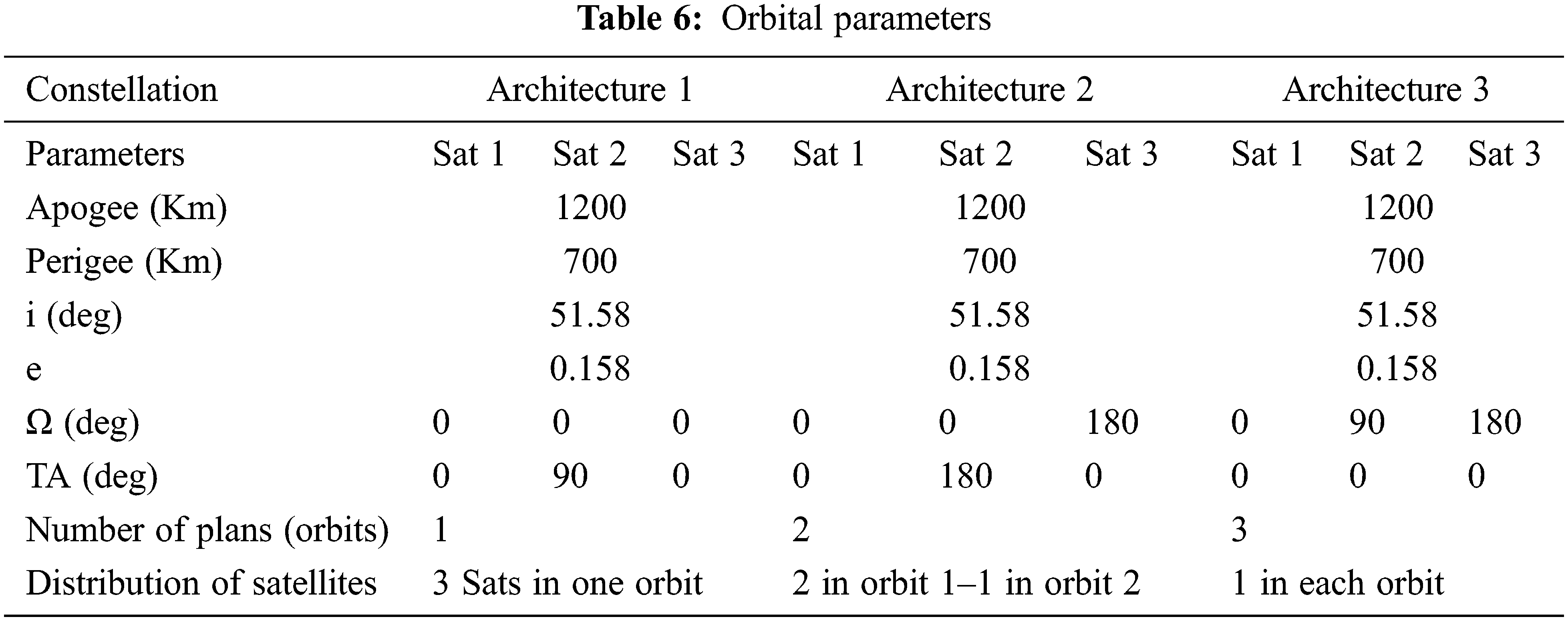
Here, the opposing question is the number of orbits adequate to meet the requirements of the mission. To accomplish this goal in choosing the best architecture, three parameters were considered to compare the reliability between three possible architectures: intervals of coverage, revisit time and total coverage duration. Table 6 presents the parameters of the three possible architectures.
In order to select the appropriate architecture for the mission, simulations were performed using the same parameters for the three architectures including, apogee, perigee, inclination and eccentricity with different ascending node (Ω) and True Anomaly (TA). Therefore, the adequate architecture is that provides the maximum coverage duration with the minimum revisit time. This led to perform simulations using satellite software toolkit to extract the required analysis. This software is dedicated for analyzing and visualizing complex system in the context of space missions [33].
Indeed, this work’s main objective is to cover Saudi Arabia region for quasi-permanent time. Thus, the simulations were conducted to choose the suitable architecture. The intervals of coverage are presented in Figs. 3–5.
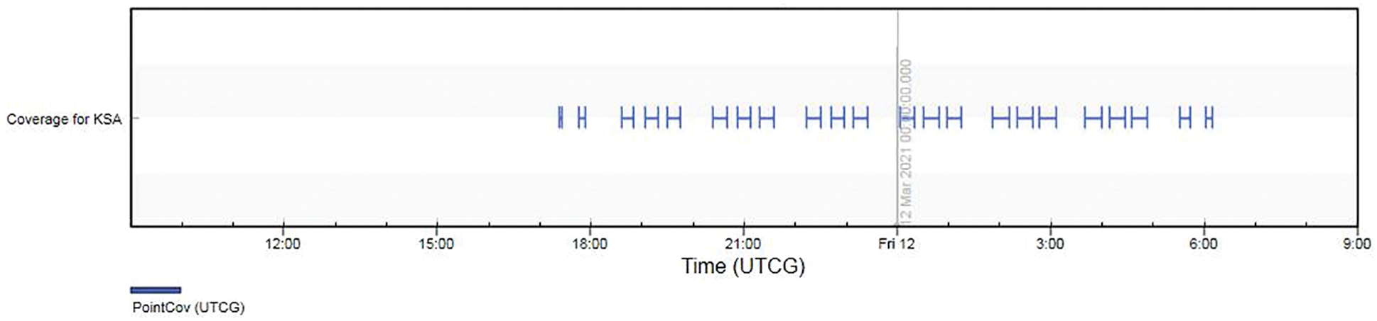
Figure 3: Coverage intervals of architecture 1
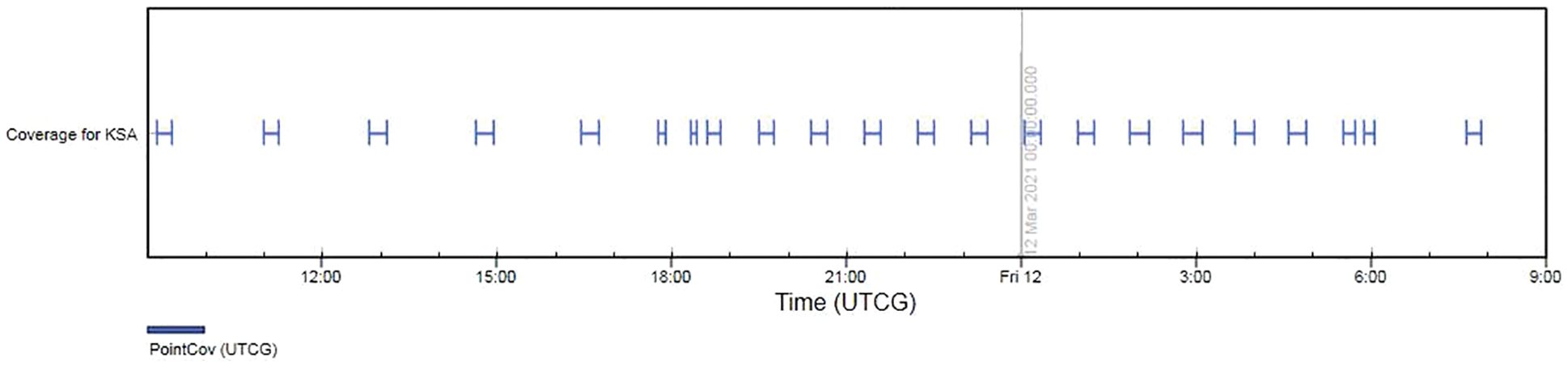
Figure 4: Coverage intervals of architecture 2
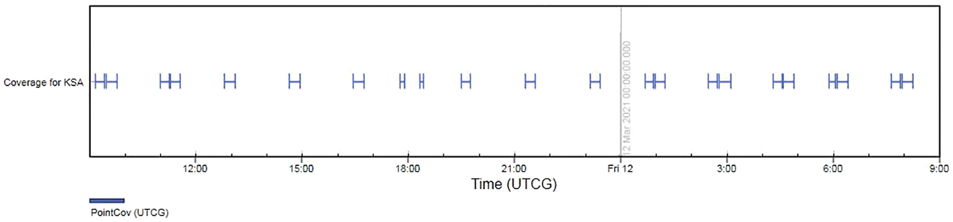
Figure 5: Coverage intervals of architecture 3
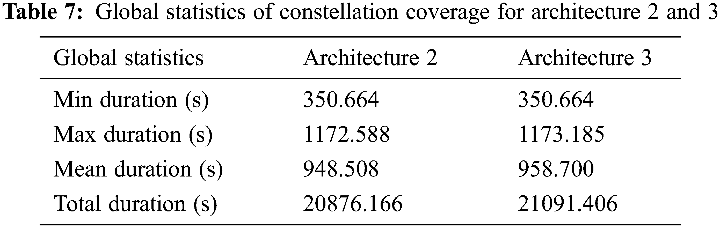
Regarding the objective of reducing the revisit time of satellites, we can exclude the architecture 1 as it presents a large period of lack of coverage. Considering the duration of total coverage, we can choose the adequate architecture from architecture 2 and architecture 3. The simulations conducted to extract the global statistics presented in Table 6.
Based on Table 7 we can deduce that these architectures present relative similarity in term of coverage duration. Thus, the chosen architecture is that deals with the simplest method of launching method. According to this brief analysis we choose architecture 2 to meet the mission requirements.
The report of the nanosatellites coverage for architecture 2 is summarized in Table 8 based on parameters presented in Table 6.
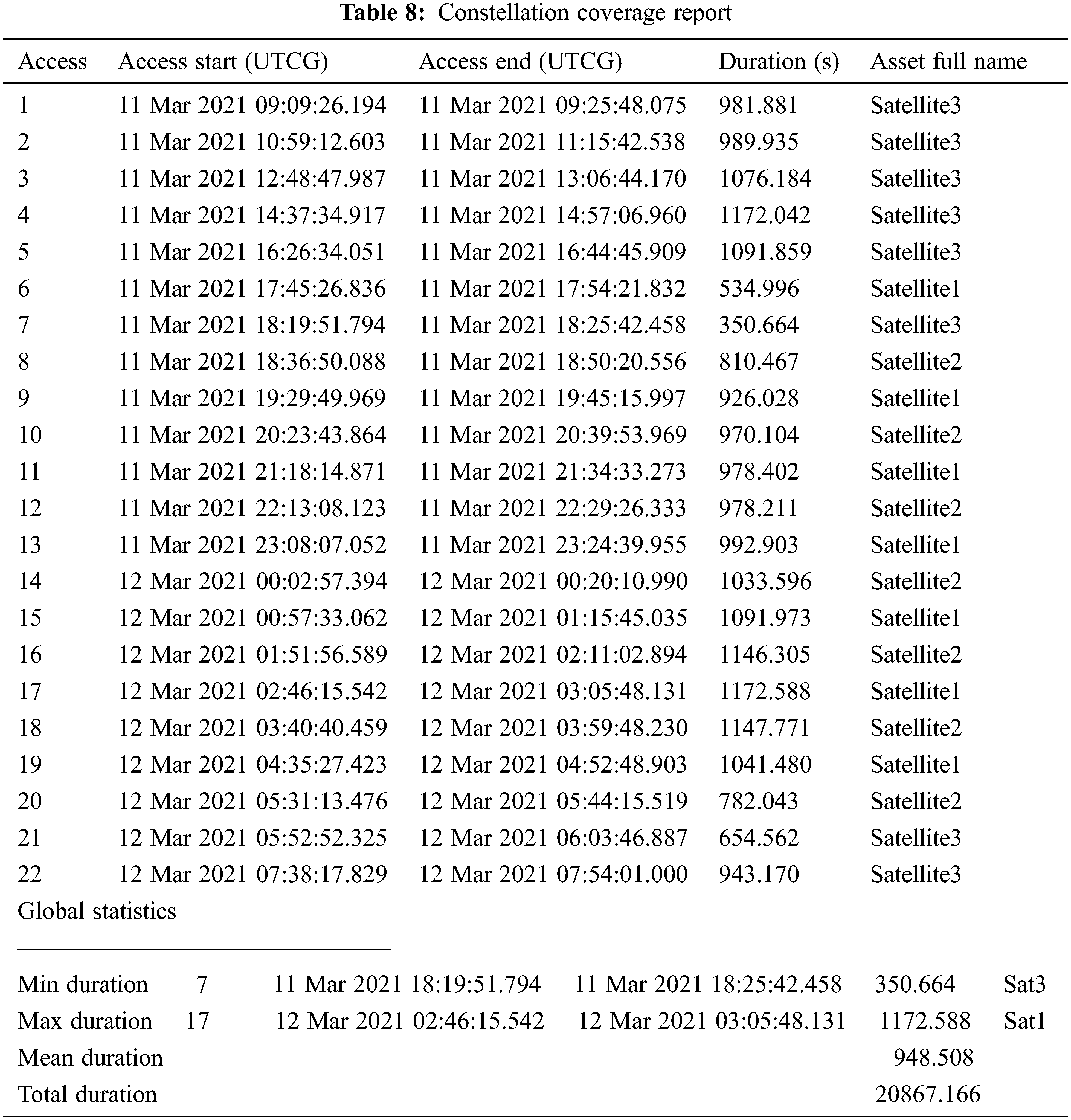
The simulation results a good performance in term of amount of daily data that can be sent. This constellation provides a reliable communication method to increase the patients’ detection. The total data that can be sent during three satellites’ visits can reach about 400.650 Mb. It is a great platform to limit the spread of pandemic, which can be more efficient when applying this technique using a network of satellites that can participate in this mission.
Several applications were conducted using a constellation of nanosatellites, such as the application of disaster monitoring presented in [34]. Here, the nanosatellites reside in the LEO at an altitude of 670 km for each nanosatellite, which are distributed as indicated in Fig. 6.
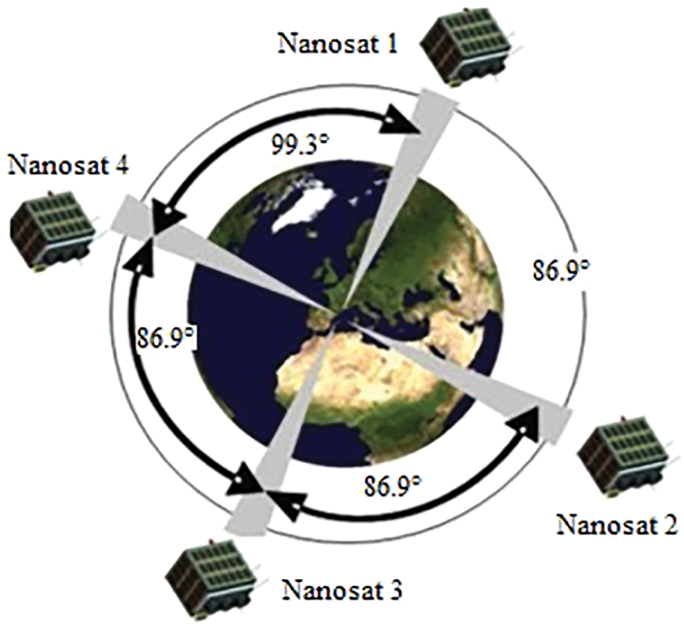
Figure 6: Satellite constellation [34]
Indeed, the proposed architecture developed in this paper’s work provides better results than those of Kameche, et al., in term of mean duration per visibility as shown in Table 8. Results are illustrated in Table 9.
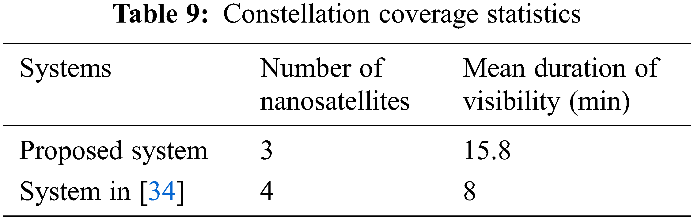
We can deduce from the table that the mean duration of visibility reached by the provided architecture can meet the desired objective in detecting the maximum number of infected peoples. Using the communication specifications presented in Table 2, the proposed system allows to send about 738 images in one orbiting cycle. Thus, this system allows to send all the data of two drones in one satellite visit, considering all the data are from infected peoples, for a critical fact.
This allows the proposed system to meet the main objective of the mission providing a reliable architecture for efficient monitoring application. Indeed, the simulation performed based on the proposed system proves its efficiency in increasing the mean duration of visibility decreasing the number of needed satellites for covering the desired zone. For one day, the proposed architecture can reach approximately 5.8 h as total duration of coverage (Table 8). This allows to send about 21870 images.
The mission analysis of this work provides a great platform for improving the health care in remote area. The proposed system is based on new wireless communication techniques. It includes the satellite technology, the communication bridges, and the communication requirements analysis. This mission proves it efficiency in COVID-19 monitoring, which is increased using a constellation of 3 nanosatellites. The comparison of constellation architectures was performed to prove the efficiency of the chosen architecture. It is succeeded to reach 15.8 min as mean duration of visibility for the desired area of coverage. This led to improve the detection of infected peoples by providing the adequate coverage duration to acquire the needed data for analysis.
Otherwise, the system is based on thermal imaging data that present a real gap in term of accuracy. New system therefore was analyzed to fill this gap providing the adequate method to accomplish the mission goal. The proposed communication technique is provided the adequate method to accomplish the mission’s goal.
This system therefore can be a part of global mission that includes an increased number of satellites based on a global cooperation.
Acknowledgement: The authors would like to thank the Taif University for funding this work through Taif University Research Supporting, Project Number (TURSP-2020/277), Taif University, Taif, Saudi Arabia.
Funding Statement: Taif university was funded this work through Taif University Research Supporting, Project Number (TURSP-2020/277), A. Abdullah was received the grant, www.tu.edu.sa.
Conflicts of Interest: The authors declare that they have no conflicts of interest to report regarding the present study.
References
1. PNUD, “Humanity needs leadership and solidarity to defeat the coronavirus,” 2020. [Online]. Available: https://www.undp.org/content/undp/fr/home/coronavirus.html. [Google Scholar]
2. A. Tahamtan and A. Abdollah, “Real-time RT-PCR in COVID-19 detection: Issues affecting the results,” Expert Review of Molecular Diagnostics, vol. 20, no. 5, pp. 453–454, 2020. [Google Scholar]
3. M. Shen, Y. Zhou, J. Ye, A. A. A. Al-Maskri, Y. Kang et al., “Recent advances and perspectives of nucleic acid detection for coronavirus,” Journal of Pharmaceutical Analysis, vol. 2, no. 2, pp. 97–101, 2020. [Google Scholar]
4. J. Y. Noh, S. W. Yoon, D. J. Kim, M. S. Lee, J. H. Kim et al., “Simultaneous detection of severe acute respiratory syndrome, Middle East respiratory syndrome, and related bat coronaviruses by real-time reverse transcription PCR,” Archives of Virology, vol. 162, no. 6, pp. 1617–1623, 2017. [Google Scholar]
5. World Health Organisation, “Coronavirus disease (COVID-19),” 2020. [Online]. Available: https://www.who.int/emergencies/diseases/novel-coronavirus-2019/question-and-answers-hub/q-a-detail/coronavirus-disease-covid-19. [Google Scholar]
6. A. R. Watson, R. Wah and R. Thamman, “The value of remote monitoring for the COVID-19 pandemic,” Telemedicine and e-Health, vol. 26, no. 9, pp. 1110–1112, 2020. [Google Scholar]
7. T. Annis, S. Pleasants, G. Hultman, E. Lindemann, J. A. Thompson et al., “Rapid implementation of a COVID-19 remote patient monitoring program,” Journal of the American Medical Informatics Association, vol. 27, no. 8, pp. 1326–1330, 2020. [Google Scholar]
8. A. U. Morgan, “Remote monitoring of patients with covid-19: Design, implementation, and outcomes of the first 3,000 patients in COVID watch,” NEJM Catalyst Innovations in Care Delivery, vol. 1, no. 4, pp. 1–12, 2020. [Google Scholar]
9. V. Chamola, V. Hassija, V. Gupta and M. Guizani, “A comprehensive review of the COVID-19 pandemic and the role of IoT, drones, AI, blockchain, and 5G in managing its impact,” IEEE Access, vol. 8, pp. 90225–90265, 2020. [Google Scholar]
10. A. Kumar, K. Sharma, H. Singh, S. G. Naugriya, S. S. Gill et al., “A Drone-based networked system and methods for combating coronavirus disease (COVID-19) pandemic,” Future Generation Computer Systems, vol. 115, pp. 1–19, 2021. [Google Scholar]
11. M. Nasajpour, S. Pouriyeh, R. M. Parizi, M. Dorodchi, M. Valero et al., “Internet of things for current COVID-19 and future pandemics: An exploratory study,” Journal of Healthcare Informatics Research, vol. 4, no. 4, pp. 325–364, 2020. [Google Scholar]
12. M. Mohammed, N. A. Hazairin, S. Al-Zubaidi, S. AK, S. Mustapha et al., “Toward a novel design for coronavirus detection and diagnosis system using IoT based drone technology,” International Journal of Psychosocial Rehabilitation, vol. 24, no. 7, pp. 2287–2295, 2020. [Google Scholar]
13. Y. Inoue, “Satellite-and drone-based remote sensing of crops and soils for smart farming–a review,” Soil Science and Plant Nutrition, vol. 66, no. 6, pp. 798–810, 2020. [Google Scholar]
14. H. Arian, “Draganfly. draganfly selected to globally integrate breakthrough health diagnosis technology immediately onto autonomous camera’s and specialized drones to combat coronavirus (covid19) and future health emergencies,” 2020. [Online]. Available: https://www.globenewswire.com/news-release/2020/03/26/2006867/0/en/Draganfly-Selected-to-Globally-Integrate-Breakthrough-Health-Diagnosis-Technology-Immediately-onto-Autonomous-Camera-s-and-Specialized-Drones-to-Combat-Coronavirus-COVID-19-and-Fut.html. [Google Scholar]
15. Et government, “Indian robotics solution launches corona combat drone to fight covid-19,” government news, 2020. [Online]. Available: https://government.economictimes.indiatimes.com/news/technology/indianrobotics-solution-launches-corona-combat-drone-tofightcovid-19/75077517. [Google Scholar]
16. S. Yeom, “Moving people tracking and false track removing with infrared thermal imaging by a multirotor,” Drones, vol. 5, no. 3, pp. 65, 2021. [Google Scholar]
17. F. A. Almalki, A. A. Alotaibi and M. C. Angelides, “Coupling multifunction drones with AI in the fight against the coronavirus pandemic,” Computing, vol. 104, no. 5, pp. 1033–1059, 2021. [Google Scholar]
18. DJI enterprise, “DJI mavic 2 enterprise DUAL,” 2022. [Online]. Available: https://www.flyingeye.fr/product/dji-mavic-2-enterprise-dual/. [Google Scholar]
19. E. Yanmaz, S. Yahyanejad, B. Rinner, H. Hellwagner and C. Bettstetter, “Drone networks: Communications, coordination, and sensing,” Ad Hoc Networks, vol. 68, pp. 1–15, 2018. [Google Scholar]
20. A. Løfaldli and R. Birkeland, “Implementation of a software defined radio prototype ground station for cubesats,” in Proc. of the ESA Small Satellites Systems and Services Symposium, Valletta, Malta, vol. 30, 2016. [Google Scholar]
21. T. Yasin and B. Reyhan, “Circularly polarized meshed patch antenna for small satellite application,” IEEE Antennas and Wireless Propagation Letters, vol. 12, pp. 1057–1060, 2013. [Google Scholar]
22. E. F. Tubbal, R. Raad, K. W. Chin and B. Butters, “S-Band shorted patch antenna for inter pico satellite communications,” in 8th Int. Conf. on Telecommunication Systems Services and Applications (TSSA), IEEE, Kuta, Bali, Indonesia, pp. 1–4, 2014. [Google Scholar]
23. E. Bruce, “The satellite communication ground segment and earth station handbook,” Artech House, Second edition, vol. 427, Boston, London, pp. 443, 2014. [Google Scholar]
24. K. O. Michael, “Satellite Communication Engineering,” New York, USA, CRC Press, pp. 270, 2016. [Google Scholar]
25. B. Denby and L. Brandon, “Orbital edge computing: Nanosatellite constellations as a new class of computer system,” in Proc. of the Twenty-Fifth Int. Conf. on Architectural Support for Programming Languages and Operating Systems, New York, USA, pp. 939–954, 2020. [Google Scholar]
26. F. Warren Frick and N. Carlos, “Small launch vehicles-a 2018 state of the industry survey,” in Proc. AIAA/USU Conf. Small Satellites, Utah, USA, 2018. [Google Scholar]
27. S. Michael, “Cubesat database,” 2018. [Online]. Available: https://sites.google.com/a/slu.edu/swartwout/home/cubesatdatabase. [Google Scholar]
28. E. Shakhmatov, I. Belokonov, I. Timbai, E. Ustiugov, A. Nikitin et al., “SSAU project of the nanosatellite SamSat-QB50 for monitoring the earth’s thermosphere parameters,” Procedia Engineering, vol. 104, pp. 139–146, 2015. [Google Scholar]
29. L. Alminde, K. Kaas, M. Bisgaard, J. Christiansen and D. Gerhardt, “GOMX-1 flight experience and air traffic monitoring results,” 2014. [Online]. Available: https://digitalcommons.usu.edu/smallsat/2014/YearReview/5/. [Google Scholar]
30. S. Bandyopadhyay, R. Foust, G. P. Subramanian, S. J. Chung and F. Y. Hadaegh, “Review of formation flying and constellation missions using nanosatellites,” Journal of Spacecraft and Rockets, vol. 53, no. 3, pp. 567–578, 2016. [Google Scholar]
31. A. R. Jennifer, Satellite formation flying for an interferometry mission, PhD. Cranfield University, 2005. [Google Scholar]
32. J. G. Walker, “Continuous whole earth coverage by circular orbit satellite patterns,” royal aircraft establishment,” Technical Report, vol. 77044, pp. 1–80, 1977. [Google Scholar]
33. System Tool Kit (STK). 2021. [Online]. Available: https://www.agi.com/products/stk. [Google Scholar]
34. M. Kameche, H. Benzeniar, A. B. Benbouzid, R. Amri and N. Bouanani, “Disaster monitoring constellation using nanosatellites,” Journal of Aerospace Technology and Management, vol. 6, no. 1, pp. 93–100, 2014. [Google Scholar]
Cite This Article
 Copyright © 2023 The Author(s). Published by Tech Science Press.
This work is licensed under a Creative Commons Attribution 4.0 International License , which permits unrestricted use, distribution, and reproduction in any medium, provided the original work is properly cited.
 Downloads
 Citation Tools