
 Submit a Paper
 Propose a Special lssue
 Open Access
ARTICLE

Development of a Comprehensive Ground Suitability Index for Building Construction: A Case Study
1 Civil Engineering Department, College of Engineering and Technology, Romblon State University, Odiongan, 5505, Romblon, Philippines
2 Disaster Prevention Research Institute, Kyoto University, Gokasho, Uji, Kyoto, 611-0011, Japan
3 Department of Civil Engineering, Institute of Technology, Far Eastern University, Sampaloc, Manila, 1015, Philippines
* Corresponding Author: Jerome Gacu. Email:
Revue Internationale de Géomatique 2025, 34, 235-257. https://doi.org/10.32604/rig.2025.063512
Received 16 January 2025; Accepted 18 March 2025; Issue published 25 April 2025
 View Full Text
 Download PDF
Abstract
The rapid urbanization of rural areas often leads to the construction of medium to high-rise buildings without adequate knowledge of ground suitability, posing significant risks to structural safety and long-term development. This study addresses this critical issue by developing a Comprehensive Ground Suitability Index (CGSI) framework tailored for rural municipalities. Using Geographic Information Systems (GIS) and the Analytic Hierarchy Process (AHP), the CGSI integrates geophysical, geo-environmental, and geohazard parameters to systematically evaluate land suitability for construction. Data were collected from government agencies, previous studies, and field surveys focusing on the Municipality of Odiongan, Romblon. Parameters such as bearing capacity, soil type, slope, flood height, and liquefaction susceptibility were prioritized using AHP, ensuring consistency in decision-making. GIS tools were utilized to overlay weighted parameters, producing maps that categorize areas into suitability levels. Results reveal that Barangays Poctoy and Amatong are highly suitable for construction, while the Poblacion area exhibits marginal suitability due to high flood and liquefaction risks. The CGSI framework provides a structured, replicable approach to integrating multicriteria decision-making into urban planning, offering valuable insights for safe and sustainable development. This study underscores the urgency of combining GIS and AHP to address land-use challenges in rapidly urbanizing rural areas. The framework equips local governments with the tools to refine land use policies, mitigate hazards, and promote resilient urban development. Future research can enhance the CGSI by incorporating additional datasets and advanced modelling techniques to improve its applicability and precision.Keywords
Urbanization is a global phenomenon that has led to profound transformations in urban and rural landscapes. The rapid growth of urban areas often extends into rural regions, driven by population expansion and economic development. In the Philippines, urbanization in rural areas presents unique challenges due to the country’s geographic and geologic characteristics, including its location along the Pacific Ring of Fire and its exposure to frequent typhoons, earthquakes, and other natural hazards [1–3]. Rapid urbanization, coupled with these vulnerabilities, underscores the need for a systematic assessment of ground suitability to optimize building construction and minimize risks [4–6]. Despite these hazards, rural municipalities are increasingly experiencing urban expansion, often without a structured approach to ground suitability assessment. These challenges necessitate a comprehensive understanding of ground suitability to support safe and sustainable urban development.
The need for sustainable urban planning is particularly pressing in rural areas where the impacts of natural disasters are compounded by fragile ecosystems and limited infrastructure [7–9]. Practical ground suitability assessments have proven instrumental in reducing vulnerabilities and promoting resilience. Countries such as Japan, the United States, and New Zealand have pioneered advanced methodologies for assessing ground suitability in multi-hazard environments. In Japan, GIS-based hazard mapping has been extensively utilized to mitigate earthquake and landslide risks, resulting in comprehensive land-use plans prioritizing safety and resilience [10,11]. Similarly, the United States employs GIS and AHP for floodplain management, integrating high-resolution hydrological data with urban planning strategies to reduce vulnerability to flooding [12,13]. New Zealand’s approach incorporates seismic risk assessments and liquefaction susceptibility analysis into its urban planning framework, ensuring the stability of critical infrastructure in earthquake-prone regions [14]. These studies highlight the effectiveness of integrating spatial data and multicriteria decision-making tools to address complex urban development challenges.
The construction of medium to high-rise buildings in rural areas necessitates a thorough evaluation of ground conditions to ensure stability and resilience [15]. However, current urban management strategies in the Philippines lack a systematic, multi-hazard approach to ground suitability assessment. Traditional evaluations often rely on localized geotechnical studies and static datasets, which do not fully capture the complex interactions between geophysical, geo-environmental, and geohazard factors. For instance, hazard assessments are often conducted separately without integrating flood [16–18], landslides [19,20], and liquefaction [5] risks into a unified framework. This fragmented approach limits planners’ ability to identify safe and sustainable construction zones, increasing the risk of structural failures and environmental degradation. Therefore, there is a need for an integrated, spatially explicit framework that systematically evaluates land suitability for urban development in hazard-prone rural areas.
Urban management in the Philippines also faces significant gaps in incorporating multi-hazard assessments into planning processes. Many rural and peri-urban municipalities lack comprehensive hazard susceptibility maps, particularly for flooding [21–23], landslides, and liquefaction. Climate change, deforestation, and poor land-use practices further exacerbate these risks, yet existing planning frameworks do not adequately integrate these factors. Landslides, similarly driven by slope instability and soil erosion, pose critical risks, particularly in rural regions where land-use planning often overlooks geohazard assessments [19]. Similarly, the impact of seismic activity on liquefaction-prone areas remains underexplored, with limited integration of geophysical and seismic data into land-use planning. Addressing these gaps requires a robust, GIS-based framework that consolidates spatial hazard assessments with urban planning methodologies, ensuring a more comprehensive and data-driven approach to rural urbanization [24,25].
Efforts in other countries demonstrate the potential of advanced methodologies to bridge these gaps. In other countries, GIS-based models have been applied to assess volcanic, flood, and landslide risks, producing hazard maps that inform zoning regulations and disaster preparedness measures [24,26–28]. Similarly, researchers have utilized AHP and GIS to evaluate ground suitability for urban expansion in flood-prone areas, emphasizing the need for community-centric disaster risk reduction strategies [16,29,30]. These examples underscore the importance of adopting integrated approaches to ground suitability assessments in hazard-prone regions.
Ground suitability analysis critically evaluates a site’s physical, environmental, and hazard-related characteristics to determine its capacity to support building structures safely and sustainably [31,32]. It begins with collecting spatial data on variables such as soil stability, topography, land use, hydrology, and hazard vulnerability, which are then integrated into GIS for analysis. Techniques like Multicriteria Decision Analysis (MCDA) are employed to weigh and rank these variables, enabling planners to evaluate competing land-use options objectively. GIS-MCDA provides a robust framework by combining spatial data visualization with decision-making tools, enhancing the precision and relevance of suitability assessments [30,33]. This approach ensures that urban development aligns with long-term sustainability goals by addressing risks like flooding, landslides, and resource constraints while optimizing land use for infrastructure, housing, and other needs. Studies have demonstrated the effectiveness of these methods in generating high-resolution suitability maps guiding urban planners in making informed, resilient, and sustainable decisions.
Recent advancements in GIS and MCDA tools, such as the multicriteria decision analysis, have significantly enhanced ground suitability analyses. GIS enables the integration and visualization of diverse spatial datasets, including soil composition, topography, hydrology, and land use, providing a robust platform for comprehensive spatial analysis [34–36]. AHP, on the other hand, allows for the systematic prioritization of factors influencing ground suitability, ensuring balanced and data-driven decision-making [37–39].
In addition, techniques such as Inverse Distance Weighting (IDW) interpolation have improved the precision of soil and geohazard mapping, facilitating the creation of high-resolution, location-specific datasets. Studies have demonstrated the potential of these methods to inform construction planning and mitigate risks associated with unstable ground conditions [40,41]. For example, a study in Turkey utilized IDW and AHP to develop detailed geohazard maps for earthquake and landslide-prone areas, enabling safer infrastructure planning and reducing disaster impacts [42]. Similarly, in Bangladesh, GIS-based flood hazard mapping has been instrumental in guiding agricultural land use and infrastructure development in floodplain regions [43,44].
Extending urban development into rural areas in the Philippines highlights several pressing issues. These include limited access to accurate geospatial data, inadequate integration of multi-hazard analyses in planning, and the lack of institutional capacity to adopt advanced technologies. Rural areas, often characterized by fragile ecosystems and limited infrastructure, are particularly vulnerable to the compounded impacts of natural hazards [45]. For instance, the absence of effective slope management and flood control measures in many rural municipalities has increased disaster risks, undermining the sustainability of urban expansion [46,47]. Moreover, the growing demand for multi-story structures in rural municipalities like Odiongan, Romblon, necessitates a localized yet scalable approach to ground suitability assessments. Addressing these challenges requires the integration of state-of-the-art geospatial technologies and community-driven urban planning to ensure both safety and sustainability in rapidly developing areas.
Developing a Comprehensive Ground Suitability Index (CGSI) offers a pathway to address these challenges. By integrating GIS and AHP, the CGSI framework facilitates the systematic evaluation of geophysical, geo-environmental, and geohazard parameters, providing a holistic approach to risk-informed urban planning. This study focuses on Odiongan, Romblon, a municipality undergoing rapid urbanization, to illustrate the applicability of the CGSI in identifying suitable sites for building construction. The CGSI aims to support policymakers and planners in promoting resilient and sustainable development by addressing gaps in current methodologies and incorporating dynamic spatial analyses. Aligned with global frameworks such as the Sendai Framework for Disaster Risk Reduction, the CGSI underscores the importance of resilience in urban planning. This approach mitigates risks associated with natural hazards and enhances the sustainability and livability of urban expansions into rural areas. The findings from this study provide valuable insights for other disaster-prone regions, offering a replicable model for integrating advanced technologies into urban resilience strategies.
The study was conducted in the town proper of Odiongan, Romblon, as shown in Fig. 1, a municipality in the central Philippines. Odiongan has diverse topographical features, including coastal plains, rolling hills, and elevated terrains [48]. This region’s susceptibility to natural hazards, such as typhoons, landslides, and flooding, coupled with its ongoing urban expansion, necessitates a detailed assessment of ground suitability. Municipality of Odiongan, classified as a 1st class municipality in 2025 [49], was selected as the study area due to its strategic significance as a rapidly urbanizing region experiencing substantial developmental pressures. The study area spans both rural and peri-urban regions, providing a comprehensive landscape for evaluating the effectiveness of the CGSI framework in diverse conditions [47,50].
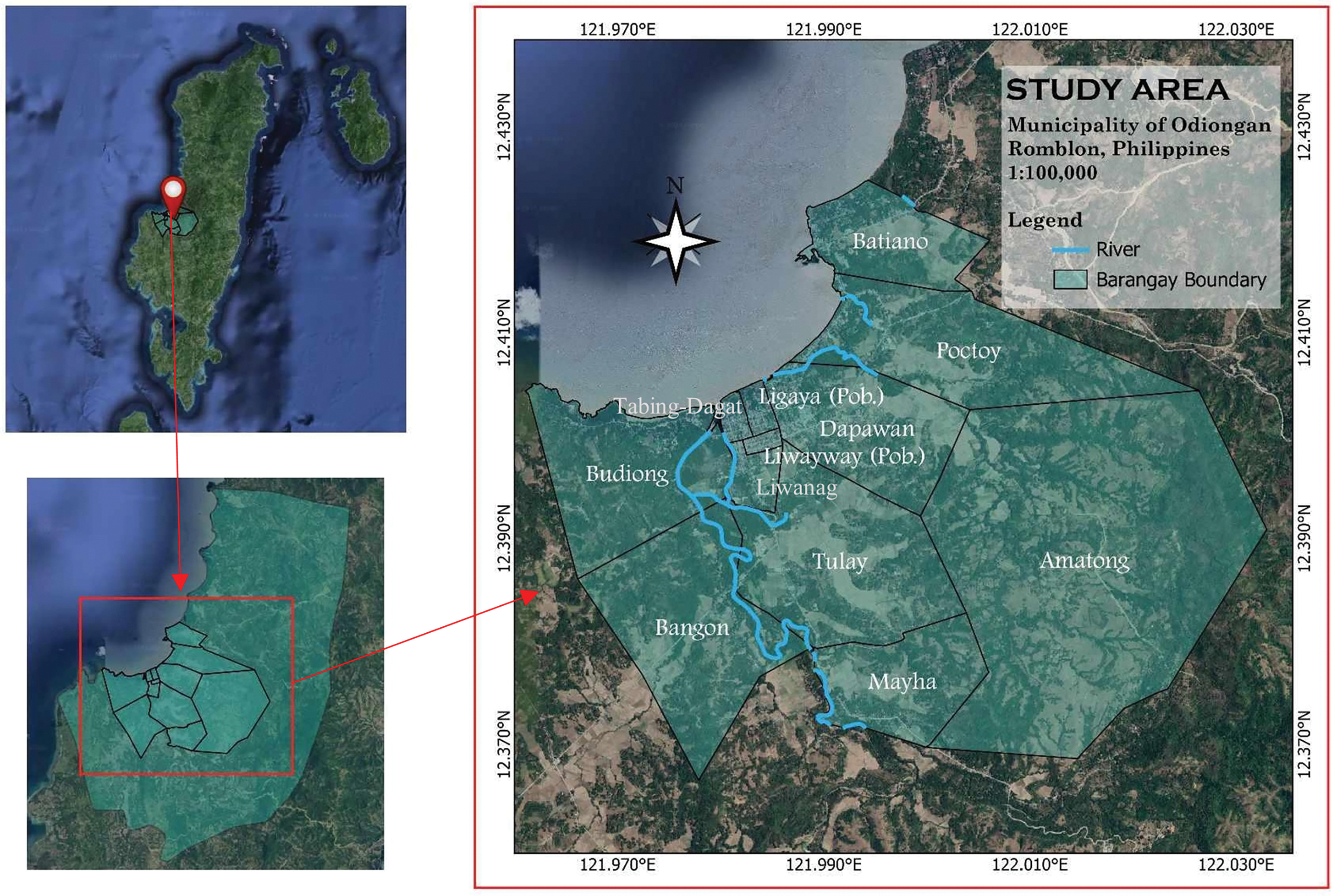
Figure 1: The study area focuses on the town proper of Odiongan, emphasizing areas under rapid urban development and proximity to river networks, crucial for the ground suitability assessment
2.2 Concept of Making the CGSI
The CGSI framework integrates GIS and the AHP to evaluate and prioritize land parcels for urban development systematically. This concept relies on merging geospatial data with decision-making tools to assess the interplay of geophysical stability, environmental factors, and hazard vulnerabilities [31,51]. This structured approach ensures comprehensive and replicable ground suitability assessments adaptable to other regions with similar challenges. A conceptual representation of the CGSI framework is illustrated in Fig. 2, which visualizes the relationship between the geophysical, geo-environmental, and geohazard parameters and their integration into the comprehensive ground suitability index. This figure highlights the intersection of these parameters and their combined influence on suitability evaluations.
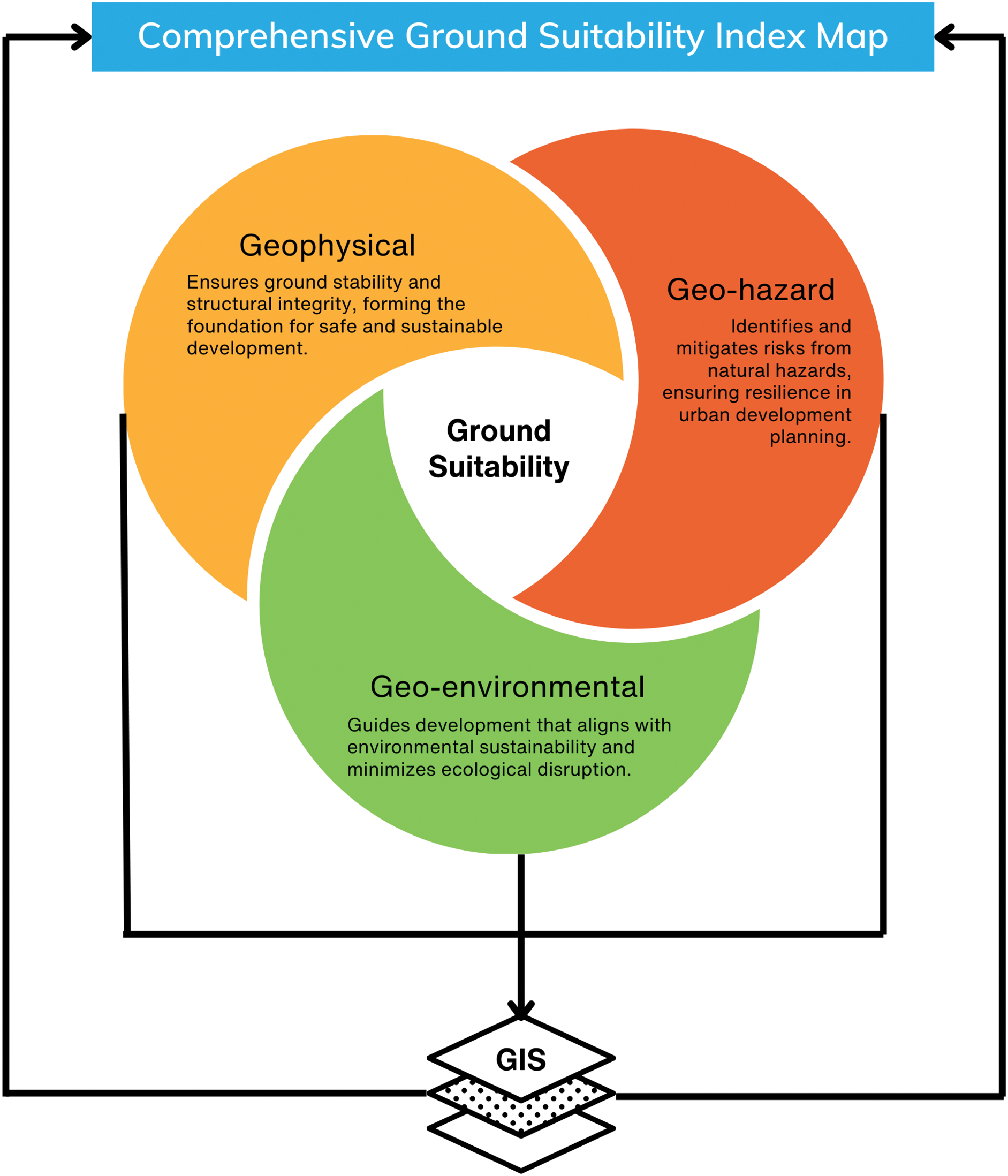
Figure 2: The proposed concept of the CGSI framework that integrates geophysical, geo-environmental, and geohazard parameters using GIS tools, providing a structured approach for sustainable and hazard-resilient urban development planning
2.3 Identification of Parameters
Developing a comprehensive ground suitability framework relies heavily on accurate and detailed data from multiple credible sources. This study obtained key datasets from local government units, national agencies, and prior research studies. Local government offices provided essential data on land use plans, zoning regulations, and demographic profiles, while agencies contributed critical geospatial information, including digital elevation models, hazard maps, and geological surveys. Furthermore, the parameters considered in this study were selected based on relevant data and an extensive literature review, ensuring the inclusion of factors most pertinent to geophysical stability, environmental sustainability, and hazard resilience. These parameters, derived from accessible datasets, were instrumental in structuring the GIS framework for this research.
Given that data availability varies across parameters, this study prioritized the most recent and reliable datasets. Geophysical parameters (e.g., soil type, bearing capacity) are relatively stable over time and were used as-is. In contrast, geo-environmental and geohazard parameters (e.g., land use, flood height) are subject to change due to urbanization and climate-related factors, necessitating the use of the latest government records and validated hazard assessments. The impact of interannual variation was mitigated by selecting datasets that align with current urban planning conditions. However, since data collection remains limited in rural areas, the CGSI framework is designed to be adaptable, allowing updates as newer datasets become available. Future research should integrate remote sensing and continuous monitoring to improve temporal consistency and ensure a more dynamic assessment of ground suitability.
The geophysical parameters are crucial for understanding the physical properties of the ground, which directly impact its stability and structural capacity to support buildings. By assessing factors like subsurface conditions and soil characteristics, geophysical analysis ensures that foundations are designed to withstand structural loads and minimize risks of settlement or failure [52,53]. These evaluations contribute to safe and efficient urban development, aligning construction practices with the ground’s inherent physical capabilities.
Geo-environmental parameters focus on the interaction between land and environmental features, considering terrain configuration and land-use patterns. These parameters help identify areas where sustainable urban development can occur while minimizing environmental degradation [54,55]. By analyzing these environmental interactions, the study supports ecosystem preservation and ensures that urban expansion is in harmony with natural surroundings, promoting long-term sustainability.
Geohazard parameters identify and assess risks associated with natural and anthropogenic hazards, such as landslides, earthquakes, and floods, which can compromise the safety of urban development. Understanding these hazards allows planners to design mitigation measures and implement disaster-resilient strategies [56]. Integrating hazard analysis into the ground suitability framework ensures infrastructure protection and enhances community resilience against potential disasters.
The parameters were evaluated using the AHP to systematically determine the relative importance of each parameter in assessing ground suitability. Experts from geotechnical engineering, urban planning, and local government units participated in pairwise comparisons, offering critical insights into the significance of various criteria. Surveys were distributed online and in printed forms to gather expert judgments. The outputs of AHP informed a comprehensive ground suitability assessment, ensuring data-driven prioritization of factors [57].
The decision-making process was structured into a hierarchy, which included the primary goal (ground suitability), criteria (geophysical, geo-environmental, and geohazard), and alternatives (specific parameters under each criterion). A pairwise comparison matrix was constructed to evaluate the relative importance of each criterion. Each comparison was scored on a nine-point intensity scale, with weights normalized to a scale of 1 to 5. The matrix was processed using eigenvalues to derive parameter weights, as described in Eq. (1):
The pairwise comparison matrix A (Eq. (2)) was represented as:
The normalized weights were calculated for each parameter by dividing individual values in the matrix columns by their respective totals. The normalized principal eigenvector (w) representing the weights was derived by averaging the normalized rows. The consistency of the judgments was ensured by calculating the largest eigenvalue (ymax) as indicated in Eq. (3):
The Consistency Index (CI) was computed as (Eq. (4)):
The Consistency Ratio (CR) was then determined using the Formula (5):
where RI is the random index based on the size of the matrix. A CR value below 0.1 indicated acceptable consistency; otherwise, the matrix was revised.
2.5 Development of the CGSI Map
The CGSI map was developed through a weighted linear combination (WLC) approach in GIS. Parameter maps were created using tools such as QGIS and ArcGIS. For instance, slope maps were derived from DEMs, and flood height maps were based on hydrological data. Normalization was applied to parameter values to create a consistent scale, enabling integration into a composite map. The final suitability score was calculated using the Formula (6):
where S is the suitability score, wi is the weight of parameters i, and xi is the normalized parameters value [31]. The resulting scores were classified as “Highly Suitable”, “Moderately Suitable”, and “Not Suitable”. Validation of the CGSI map was achieved through field surveys, expert reviews, and comparisons with historical data. Adjustments based on validation feedback enhanced the reliability of the CGSI framework. The CGSI methodology provides a robust, data-driven approach to assessing ground suitability for urban development. It ensures that urban planning decisions in hazard-prone areas like the Municipality of Odiongan, Romblon, are grounded in comprehensive spatial and analytical insights, contributing to sustainable and resilient development.
The study results align with the conceptual framework, focusing on data analysis, evaluation, and assessment of parameters using the AHP and developing the CSGI Map. The results highlight the integration of geophysical, geo-environmental, and geohazard parameters, offering valuable insights for local governments and stakeholders to identify suitable areas for building construction.
3.1 Data Analysis for Identified Parameters
The parameters were categorized into three main groups—geophysical, geo-environmental, and geohazard—based on their relevance to assessing ground suitability. The decision hierarchy in this study was structured into three distinct levels (Fig. 3). At the top level was the primary goal of developing a comprehensive ground suitability map. The second level consisted of the three main criteria—geophysical, geo-environmental, and geohazard parameters—representing the key factors influencing ground suitability. The third level included specific indicators under each criterion, such as bearing capacity, soil type, slope, liquefaction hazard, and flood height. This hierarchical structure provided a clear framework for organizing and analyzing the relationships among the various factors, ensuring that the study’s objectives were systematically addressed. Table 1 summarizes the parameters, data types, sources, and acquisition duration. The parameters were selected from the literature reviews, datasets, past studies, and expert consultations.

Figure 3: The diagram illustrates the hierarchical categorization of ground suitability criteria into geophysical, geo-environmental, and geohazard groups, each encompassing specific parameters critical for comprehensive ground suitability evaluation

Data were sourced from the most recent and available government databases and studies. Due to limitations in rural areas, some datasets are from different years based on availability. However, key parameters exhibit minimal short-term changes, ensuring their relevance for assessing ground suitability. Future updates incorporating real-time hazard monitoring and climate projections are recommended for improved accuracy. Spatial analysis was conducted using GIS tools, with spatial maps developed at a resolution 1:100,000 to enhance precision and visualization. The study focused on areas with comprehensive data availability, particularly the town proper, ensuring a detailed assessment of geophysical, geo-environmental, and geohazard factors.
Advanced GIS techniques were employed for data processing and analysis. The Inverse Distance Weighted (IDW) interpolation method created continuous surfaces for geophysical parameters such as soil texture and bearing capacity. Slope and elevation data were derived from IfSAR DTM using slope analysis tools in QGIS. River proximity was analyzed through network-based distance calculations, providing detailed insights into hydrological risks. Additionally, thematic layers such as land use and hazard susceptibility maps were generated and integrated through weighted overlay analysis, ensuring a comprehensive spatial assessment. This methodological approach enabled the precise delineation of suitability levels across the study area, facilitating a robust understanding of spatial patterns and interactions between geophysical, geo-environmental, and geohazard parameters. Fig. 4 shows the resulting maps of all the parameters per criteria.
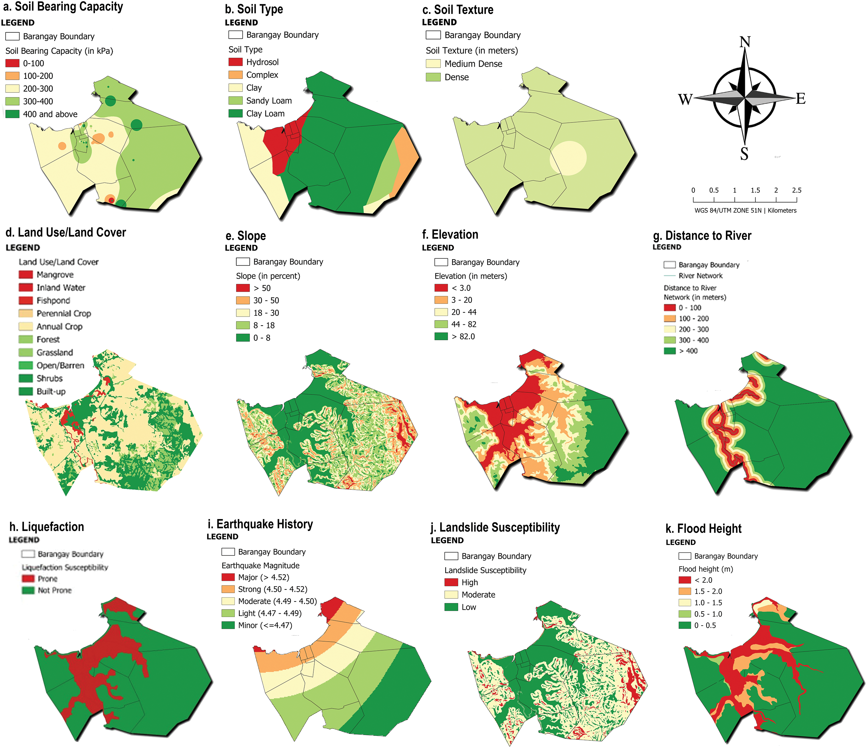
Figure 4: Mapping results of ground suitability parameters: (a–c) geophysical (soil bearing capacity, soil type, soil texture), (d–g) geo-environmental (land use/land cover, slope, elevation, distance to river), and (h–k) geohazard (liquefaction, earthquake history, landslide susceptibility, flood height)
The geophysical parameters analyzed in this study include soil-bearing capacity, soil type, and soil texture, which are crucial in assessing the ground’s structural stability and load-bearing capacity. The soil bearing capacity map (Fig. 4a), derived from data at depths of 3.0 to 4.5 m, categorizes the area into five levels: 0–100, 100–200, 200–300, 300–400, and >400 kPa. In the town proper, the bearing capacity ranges from 100 to 300 kPa, making it suitable for light to moderate structures, while parts of barangay Poctoy, Batiano, and Amatong show values of 300–400 kPa, indicating higher suitability for heavier structures. The soil type map (Fig. 4b) highlights five categories—hydrosol, complex, clay, sandy loam, and clay loam. Clay loam, which predominates in the outer areas, provides higher structural stability, whereas the Población primarily consists of hydrosol, posing challenges for construction due to its high water-retaining properties. Lastly, the soil texture map (Fig. 4c) integrates data from depths of 3.0 and 4.5 m, illustrating a transition from medium-dense at shallower depths to dense or very dense at greater depths. However, while the original dataset contained more variations, the interpolation process resulted in the representation of only two dominant soil types. These geophysical parameters collectively provide critical insights into the structural viability of different areas within the study region. These geophysical parameters collectively provide critical insights into the structural viability of different areas within the study region.
3.1.2 Geo-Environmental Parameters
Geo-environmental parameters, including land use/land cover, slope, elevation, and proximity to river networks, provide critical insights into environmental conditions and topographical challenges. The land use map (Fig. 4d) classifies the study area into nine categories: built-up areas, annual crops, grasslands, and mangrove forests. The Población is primarily a built-up area that supports urban development, while the surrounding areas are predominantly agricultural or shrubland. The slope map (Fig. 4e) categorizes the terrain into five levels, ranging from 0%–8% (level) to >50% (mountainous). The Población features mostly flat terrains, making it ideal for construction, whereas steeper slopes in outer barangays require stabilization measures to mitigate risks. Elevation (Fig. 4f) levels vary from ≤3 to >82 m, with low-lying areas like the Poblacion more prone to flooding and storm surges. In contrast, higher elevations pose slope management challenges but are less vulnerable to water-related hazards. As shown in Fig. 4g, proximity to rivers, categorized into five levels, highlights areas within 0–300 m, such as the Población and nearby barangays, which face heightened flooding risks and require robust drainage systems to reduce potential hazards.
Geohazard parameters, encompassing liquefaction hazard, landslide susceptibility, historical earthquake magnitudes, and flood height, provide essential insights for disaster-resilient planning. The liquefaction hazard map (Fig. 4h) highlights high-risk areas, particularly in the Población and nearby barangays such as Budiong and Batiano, necessitating specialized foundation designs to mitigate potential impacts. Historical earthquake magnitudes (Fig. 4i) range from minor to major, with coastal areas near the Población exhibiting higher magnitudes, emphasizing the need for earthquake-resistant construction. Landslide susceptibility (Fig. 4j) increases with slope steepness; central areas show low susceptibility, while hilly barangays exhibit moderate to high risks, requiring slope stabilization measures. Flood height levels (Fig. 4k), categorized into five ranges, reveal that the Población experiences depths exceeding 2.0 m. At the same time, adjacent barangays also face substantial flood risks, underscoring the importance of elevated construction or the incorporation of flood-resilient design strategies.
The evaluation and assessment of ground suitability parameters were systematically conducted using the AHP, a widely recognized MCDA tool. This method enabled the researchers to objectively determine each parameter’s relative importance, ensuring transparency and accuracy in prioritization. The weight determination process was enriched by the contributions of ten (10) experts from various fields, including construction engineering, structural engineering, geotechnical engineering, and GIS. Their diverse expertise ensured that all critical aspects of ground suitability were comprehensively addressed, increasing the reliability and depth of the analysis.
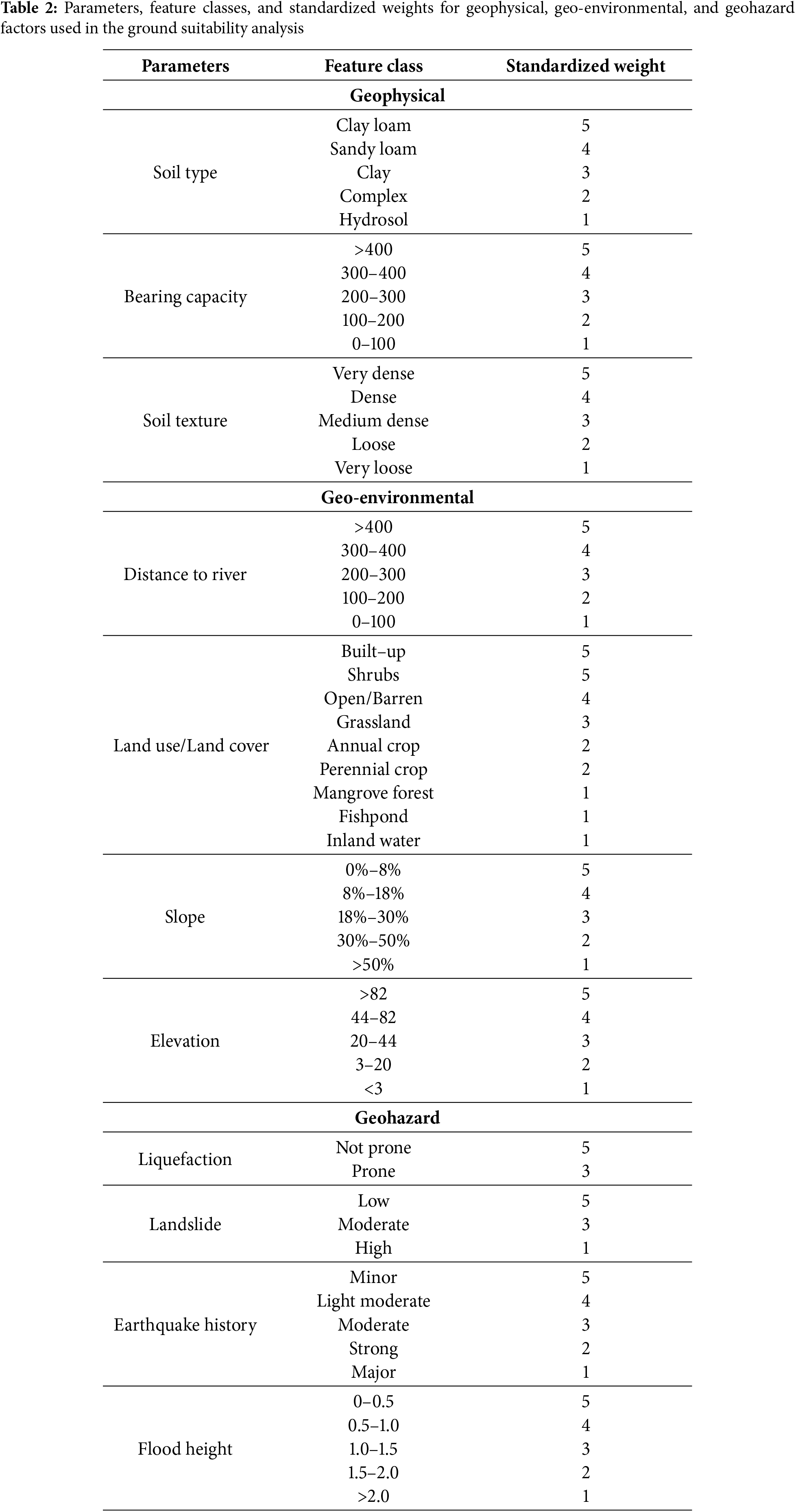
To quantify the relative importance of each parameter, feature weights were assigned using the AHP framework. Parameters were standardized on a scale of 1 to 5, with 1 indicating the least priority and 5 indicating the highest. For instance, in geophysical parameters, clay loam soil type and high bearing capacity (>400 kPa) were assigned the highest weights due to their critical role in ensuring structural stability. Similarly, in geo-environmental parameters, built-up areas and slopes between 0%–8% were given the highest weights for their favourable construction conditions. In geohazard parameters, low landslide risk and minimal flood height (0–0.5 m) received the highest weights, emphasizing their importance in maintaining safety. Table 2 provides a detailed breakdown of the standardized weights assigned to each parameter.
The reliability of the AHP results was ensured through the calculation of the CR, a critical metric for evaluating the coherence of pairwise comparisons. Ouma et al. (2014) [57] recommended that judgments were inconsistent if the CR exceeded 0.10. When the CR was above this threshold, the process required reiteration until an acceptable value was achieved. However, achieving a CR below 0.10 posed challenges, as the pairwise comparison process often needed to be sent back to respondents for reevaluation. This is a common issue in AHP studies, as inconsistencies in comparison matrices are frequently observed [61] in cases where direct interaction with respondents was impractical—particularly in online surveys with anonymous participants—alternative methods were utilized. Based on the approach by Yadav et al. (2013) [62], a geometric adjustment method was implemented using MATLAB. This method autonomously adjusted the comparison matrix to ensure a CR within the acceptable range while maintaining the integrity of individual preferences. This adjustment process enhanced the reliability and accuracy of the AHP analysis and ensured consistent responses in the comparison matrices.
The AHP analysis, shown in Fig. 5, provided critical insights into the relative importance of parameters for ground suitability. Among the geophysical parameters, bearing capacity emerged as the most significant factor (weight = 0.35) due to its direct influence on the structural stability of buildings (Fig. 5a). Within the geo-environmental parameters, land use/land cover (weight = 0.32) and slope (weight = 0.28) were identified as the most critical for ensuring environmental sustainability and construction feasibility (Fig. 5b). For the geohazard parameters, flood height (weight = 0.34) and landslide susceptibility (weight = 0.30) were deemed the most influential indicators for maintaining safety and resilience (Fig. 5c).
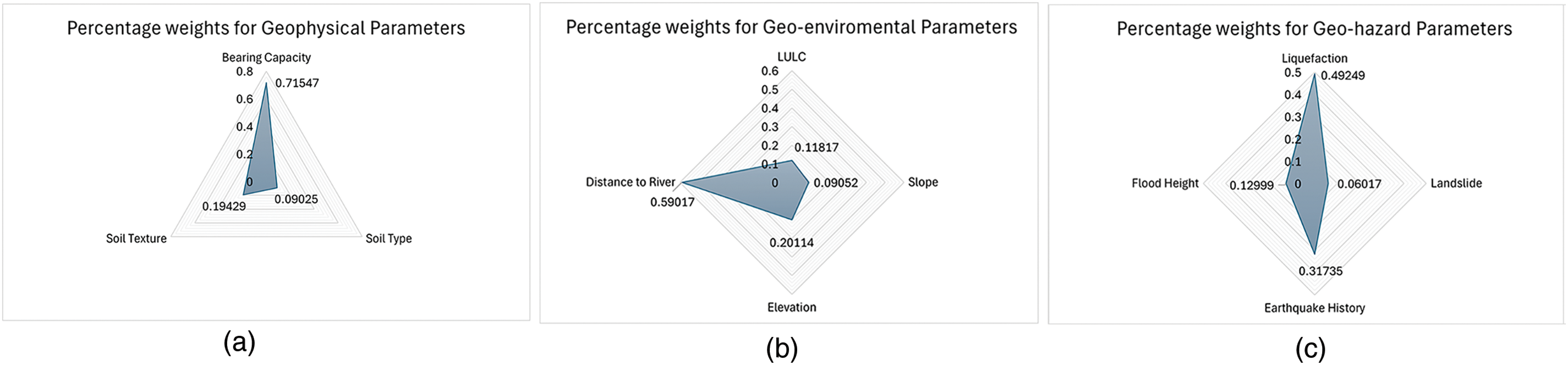
Figure 5: Percentage weights derived from AHP analysis for (a) geophysical parameters, (b) geo-environmental parameters, and (c) geohazard parameters, highlighting the prioritization of factors influencing ground suitability
3.3 Comprehensive Ground Suitability Index (CGSI) Map
The Comprehensive Ground Suitability Index (CGSI) map provides a comprehensive overview of the study area’s suitability for development, integrating geophysical, geo-environmental, and geohazard parameters. Each parameter was meticulously weighted and overlaid using the Raster Calculator tool in QGIS, resulting in distinct index maps for each criterion, as shown in Fig. 6.
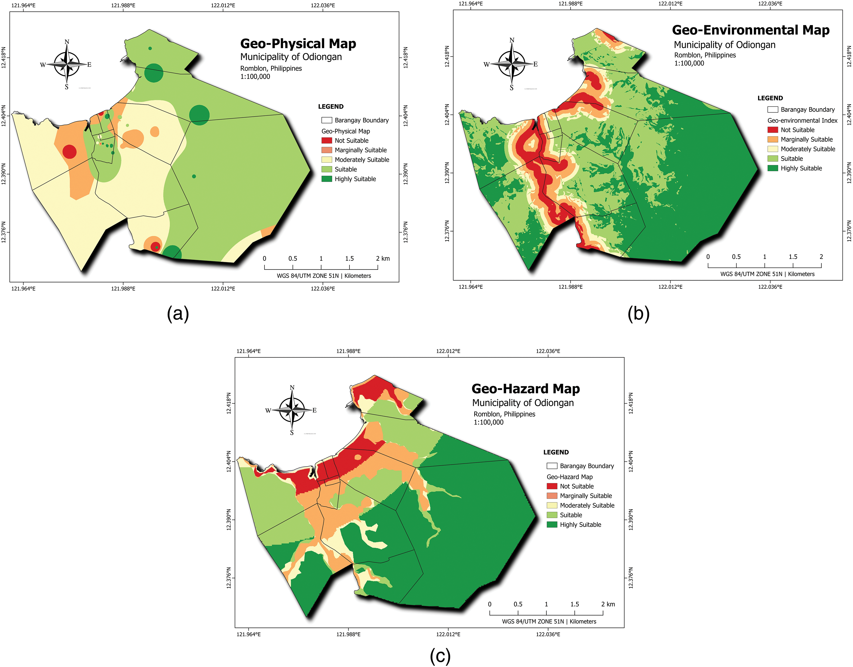
Figure 6: Composite maps showcasing (a) geophysical, (b) geo-environmental, and (c) geohazard parameters, illustrating varying levels of suitability across the Municipality of Odiongan for building construction
The Geophysical Index Map (Fig. 6a) illustrates the suitability of the area based on geophysical characteristics, including soil bearing capacity, soil type, and soil texture. The Poblacion area, the economic hub of the municipality, is classified as marginally suitable, primarily due to its moderate bearing capacity and soil density. On the other hand, areas such as Poctoy, Batiano, Amatong, and Mayha are classified as suitable, benefiting from higher soil density and favourable soil types. These characteristics significantly enhance their suitability for structural development, making these locations ideal for future construction projects requiring higher load-bearing capacities.
The Geo-environmental Index Map (Fig. 6b) highlights the suitability of areas based on slope, elevation, land use/land cover, and proximity to river networks. Using expert-assigned weights, the study categorized suitability into five levels, ranging from not suitable (red) to highly suitable (green). Barangays such as Poctoy, Ligaya, Budiong, Bangon, Tulay, and Mayha generally exhibit moderate to low suitability, attributed to steep slopes and proximity to water networks. However, portions of these barangays, particularly those with favourable elevation and land use classifications, demonstrate suitability for construction. Integrating these factors ensures that areas with less environmental vulnerability are identified as prime zones for sustainable development.
The Geohazard Index Map (Fig. 6c) integrates parameters such as liquefaction susceptibility, earthquake history, landslide risk, and flood height. The Poblacion area is notably classified as marginally suitable to not suitable due to its high susceptibility to liquefaction and flood hazards. This area’s low-lying nature makes it prone to flooding, especially during typhoons, while its susceptibility to liquefaction poses significant risks to structural stability. Although the Poblacion area exhibits low landslide risk due to its gentle slope, the presence of other hazards underscores the need for resilient building designs. Conversely, areas farther inland with fewer hazards, such as higher elevations away from flood-prone zones, exhibit more excellent suitability for development.
The Comprehensive Ground Suitability Map provides a comprehensive visualization of the integrated assessment of geophysical, geo-environmental, and geohazard parameters for building construction in Odiongan, Romblon. Fig. 7 showcases the suitability levels across the municipality, categorized into five classes: highly suitable (green), suitable (light green), moderately suitable (yellow), marginally suitable (orange), and not suitable (red). The map aims to guide stakeholders in identifying appropriate areas for infrastructure development, balancing structural stability, environmental sustainability, and hazard resilience.
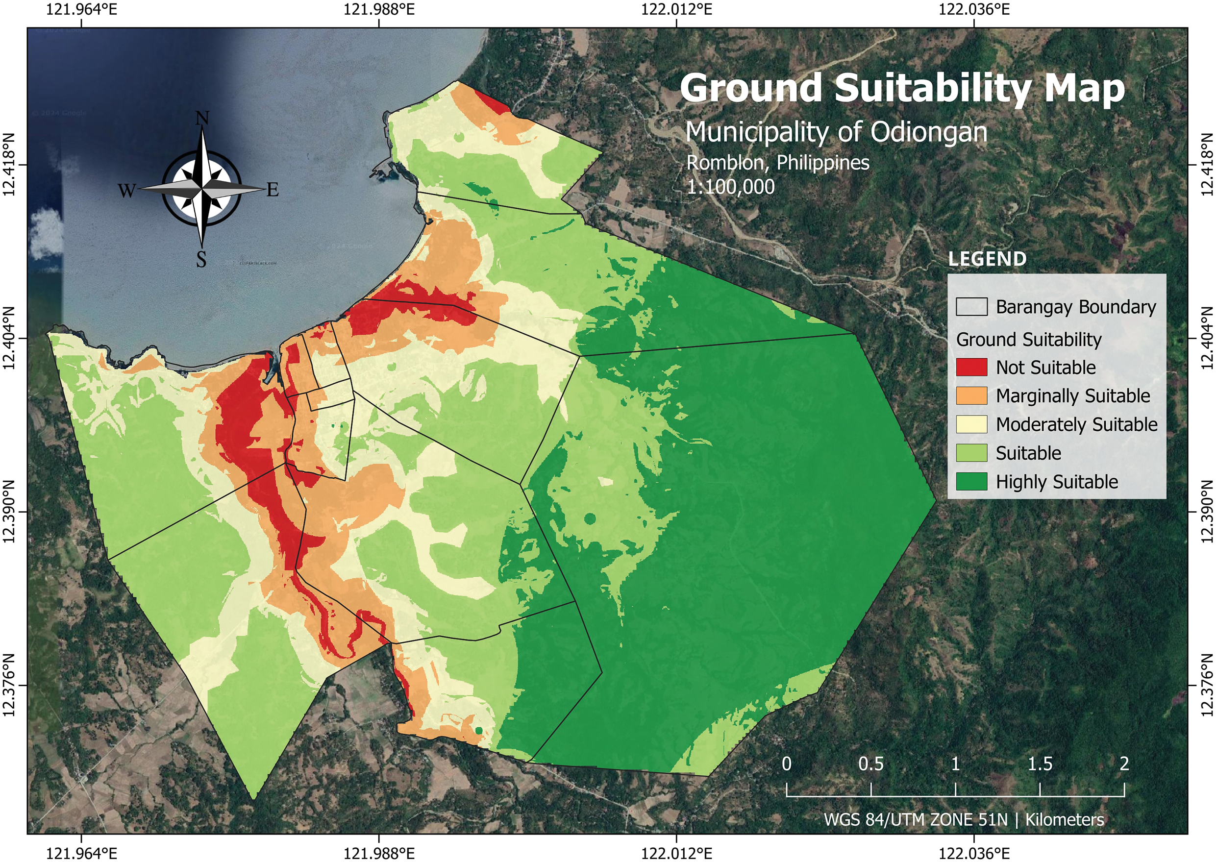
Figure 7: Comprehensive Ground Suitability Index (CGSI) map of the Municipality of Odiongan, Romblon, Philippines, integrating geophysical, geo-environmental, and geohazard parameters to illustrate varying levels of suitability for building construction
The map was generated by integrating geophysical, geo-environmental, and geohazard parameters with equal weights, deviating from the expert-assigned weights used in prior analyses. This approach assumes that all three parameter groups hold equal importance in determining ground suitability, creating an unbiased final map by averaging the contributions of each parameter. This equal-weight methodology ensures a straightforward depiction of suitability levels without prioritizing any specific criterion.
The results indicate that parts of the Poblacion area exhibit a range of suitability levels, from “not suitable” (red) to “suitable” (light green). This variability reflects the area’s susceptibility to hazards, particularly liquefaction and flooding, combined with moderate geophysical and geo-environmental characteristics. Similarly, parts of Barangays Batiano, Poctoy, Budiong, Bangon, Tulay, and Mayha predominantly show “marginally suitable” to “suitable” classifications, highlighting the moderate compatibility of these areas for construction. On the other hand, portions of Barangays Amatong and Poctoy demonstrate higher suitability, with zones classified as “suitable” to “highly suitable,” making them ideal candidates for future developments.
Utilizing this integrated map, the CGSI map provides a critical tool for local government and urban planning decision-makers. It highlights areas requiring strategic considerations to mitigate risks, particularly in hazard-prone zones, and identifies highly suitable locations for cost-efficient and sustainable construction. This map emphasizes balancing structural, environmental, and safety considerations in developing resilient and functional urban areas.
This study developed a Comprehensive Ground Suitability Index (CGSI) for the Municipality of Odiongan, focusing primarily on the town proper (Poblacion) and surrounding barangays. The CGSI framework integrates geophysical, geo-environmental, and geohazard parameters using a GIS-based MCDA. Central to the methodology is the AHP, which allowed for the structured evaluation of multiple criteria. The results highlight the CGSI’s potential as a robust tool for guiding rural municipalities in urban development planning.
GIS was instrumental in visualizing and analyzing spatially referenced data, enabling the overlay of geophysical, geo-environmental, and geohazard parameters. AHP complemented GIS by providing a systematic framework for prioritizing these parameters based on expert judgments. AHP’s ability to incorporate diverse data types and check for consistency in pairwise comparisons further enhanced the reliability of the analysis [63]. This is particularly relevant given the common challenges of achieving a consistency ratio (CR) below the acceptable threshold of 0.1 [57]. This study employed a geometric adjustment technique coded in MATLAB to address inconsistencies in expert judgments, following the methodology outlined by Yadav et al. (2013) [62]. This adjustment ensured that the CR met the acceptable threshold without significantly altering individual preferences. The robustness of this approach underscores the suitability of AHP for complex decision-making processes in rural settings, where data quality and expert availability may vary.
The CGSI results reveal varying levels of ground suitability across the municipality, categorized into five levels: highly suitable, suitable, moderately suitable, marginally suitable, and not suitable. The geophysical index highlights areas with high bearing capacity and dense soil types, particularly in Poctoy, Batiano, and Amatong, as highly suitable for construction. Conversely, areas with hydrosol-dominated soils, such as the Poblacion, were classified as marginally suitable due to challenges in water retention and load-bearing capacity. The geo-environmental index identified land use, slope, and proximity to river networks as critical factors influencing suitability. Built-up areas in the Poblacion demonstrated moderate suitability, while agricultural zones and regions with higher slopes required additional stabilization measures. The geohazard index, which included flood height, liquefaction, and landslide susceptibility, underscored the vulnerability of the low-lying regions in the Poblacion to hazards like flooding and liquefaction. These findings align with the Sendai Framework’s emphasis on disaster risk reduction in urban planning [64]. The final CGSI map synthesized these indices, providing a comprehensive overview of ground suitability for building construction. The map revealed that the Poblacion ranges from not suitable to marginally suitable due to its high vulnerability to geohazards. In contrast, parts of Poctoy and Amatong were classified as highly suitable, highlighting their potential for safe and cost-effective development.
The CGSI offers significant value for rural municipalities like Odiongan, where urban development pressures intersect with environmental and hazard constraints. The CGSI provides a holistic assessment framework that supports sustainable land use planning by integrating geophysical, geo-environmental, and geohazard parameters. This is particularly crucial for areas transitioning from rural to urban settings, where unplanned development can exacerbate vulnerability to hazards.
The utility of the CGSI extends beyond its immediate application in Odiongan. Similar frameworks have been successfully implemented in healthcare facility siting [47,65,66] and road construction projects [67], demonstrating the versatility of GIS-AHP methodologies. These studies highlight the importance of prioritizing factors based on their relative significance and ensuring the consistency of judgments through tools like CR checks. For instance, Ahmed et al. (2023) [68] emphasized AHP’s flexibility in adapting to different contexts, making it a valuable tool for addressing the unique challenges of rural urbanization.
While the CGSI provides a comprehensive assessment, its reliance on available data introduces limitations. The study utilized datasets from various government sources spanning different years, as these were the most recent and accessible data available for the study area. The impact of interannual variation is expected to be minimal for parameters such as soil type, land use, and topography, which change gradually over time. However, factors such as flood heights and seismic history may vary significantly based on extreme events and changing climatic conditions. Given these constraints, future research should explore integrating real-time hazard monitoring and updated datasets to refine the accuracy of the CGSI framework. Key parameters such as seismic history and groundwater levels were not included due to data constraints, but they could significantly improve the accuracy of the index. Seismic history is crucial for assessing long-term earthquake risks, while groundwater levels influence soil stability and construction feasibility. Future research should prioritize incorporating these parameters through improved data acquisition and collaboration with relevant agencies. Parameters such as hydrology, urban heat island effects, and land subsidence could also be integrated to refine the CGSI framework further. Future studies should explore integrating advanced techniques, such as machine learning algorithms (e.g., Support Vector Machines and Multilayer Perceptrons), to complement traditional MCDA methods [68]. Additionally, long-term monitoring data and comparisons with alternative land suitability models should be considered to enhance the CGSI’s accuracy and stability. While this study validated the CGSI through field surveys and expert assessments, integrating real-time geospatial monitoring and historical comparisons would allow for a more dynamic evaluation of its predictive capabilities. Comparative analyses with methods such as fuzzy-AHP or statistical regression models could further establish the robustness of the CGSI framework. Future research should prioritize these validation approaches to refine the model and ensure its long-term applicability in urban planning and hazard mitigation.
Moreover, the equal-weight approach used in generating the final CGSI map does not account for the varying importance of parameters, as determined by the expert panel. AHP-derived weights were used to prioritize parameters within each criterion, ensuring that the most influential factors were reflected in the individual index maps. However, in generating the final CGSI map, an equal-weight approach was applied across the three main criteria—geophysical, geo-environmental, and geohazard—resulting in a balanced yet simplified representation. Future work could refine this approach by integrating AHP weights at the final overlay stage to reflect better the relative importance of each criterion in determining overall ground suitability. While this approach simplifies the analysis, it may not fully capture the nuanced trade-offs between geophysical, geo-environmental, and geohazard factors. Future iterations of the CGSI could incorporate weighted overlays based on AHP-derived weights to enhance the map’s accuracy and relevance.
The development of the CGSI for Odiongan demonstrates the feasibility and utility of GIS-AHP methodologies for rural-urban development. By providing a detailed, multi-layered analysis of ground suitability, the CGSI empowers local governments to make informed decisions that balance safety, sustainability, and economic feasibility. As urbanization reshapes rural landscapes, tools like the CGSI will be increasingly critical in guiding resilient and inclusive development strategies.
While this study focuses on Odiongan, the CGSI framework has the potential for broader applicability in other rural municipalities experiencing rapid urbanization. The methodology can be adapted to account for regional differences in geophysical, geo-environmental, and geohazard conditions by modifying parameter weights and incorporating localized datasets. Future research should validate the CGSI model in diverse locations, including municipalities with varying climate conditions, soil compositions, and hazard exposure levels. Comparative studies using alternative land suitability assessment techniques (e.g., fuzzy logic, machine learning-based MCDA) could further assess the framework’s adaptability and robustness. Implementing the CGSI in multiple case studies would refine the model and enhance its effectiveness as a standardized tool for rural-urban development planning.
This study successfully developed a Comprehensive Ground Suitability Index (CGSI) framework tailored for rural municipalities, utilizing Geographic Information Systems (GIS) and the Analytic Hierarchy Process (AHP). The CGSI framework integrates geophysical, geo-environmental, and geohazard parameters to assess and map ground suitability for building construction systematically. By incorporating spatial data analysis and expert-driven weighting, the framework provides a structured approach to evaluate the interplay of stability, environmental factors, and hazard risks. The results emphasize the CGSI framework’s ability to identify areas suitable for construction, with Barangays Poctoy and Amatong emerging as highly suitable. In contrast, the Poblacion area exhibited marginal suitability due to flood and liquefaction risks. AHP was critical in ensuring consistent and reliable weight allocation, with adjustments addressing inconsistencies in expert pairwise comparisons. This systematic approach underpins the framework’s robustness and replicability.
The CGSI framework offers a scalable and adaptable methodology for integrating multicriteria decision-making into urban planning and development. It provides a practical tool for local governments and urban planners to refine land use policies, prioritize safe site selection, and address hazard vulnerabilities. This study serves as a foundation for future framework enhancements, such as integrating additional datasets or advanced modelling techniques, to improve its applicability and precision further. By focusing on the development and application of the CGSI, this research contributes to creating a scientifically grounded and practical decision-support tool for sustainable and resilient urban growth in rural municipalities.
Acknowledgement: The authors thank the Local Goverment of Odiongan for supporting the study. They also thank the editors and reviewers for their valuable feedback and recommendations.
Funding Statement: The authors received no specific funding for this study.
Author Contributions: The authors confirm contribution to the paper as follows: Conceptualization, Jerome Gacu; methodology, Jerome Gacu; software, Jerome Gacu, Leo Banay, Cleo Faith Forio, Eljay Soledad, and John Angelo Venus; validation, John Angelo Venus, Eljay Soledad, Anabeth Famini, April Rose Fajiculay, Jason Rufon, and Aprille Ann Sim; formal analysis, Jerome Gacu, Cleo Faith Forio, and Leo Banay; investigation, Leo Banay, John Angelo Venus, Eljay Soledad, Anabeth Famini, April Rose Fajiculay, and Cleo Faith Forio; resources, Jerome Gacu, Jason Rufon, and Aprille Ann Sim; data curation, Leo Banay, John Angelo Venus, Eljay Soledad, Anabeth Famini, April Rose Fajiculay, and Cleo Faith Forio; writing—original draft, Jerome Gacu and John Angelo Venus; writing—review and editing, Jerome Gacu; visualization, Jerome Gacu, Jason Rufon, and Aprille Ann Sim; supervision, Jerome Gacu Jason Rufon, and Aprille Ann Sim; project administration, Jerome Gacu; funding acquisition, Jerome Gacu. All authors reviewed the results and approved the final version of the manuscript.
Availability of Data and Materials: The authors agreed to turn over the necessary data and study results in the Municipality of Odiongan, Romblon, Philippines.
Ethics Approval: Not applicable.
Conflicts of Interest: The authors declare no conflicts of interest to report regarding the present study.
References
1. International Monetory Fund. Philippines selected issues. Washington, DC, USA: International Monetory Fund; 2023. [Google Scholar]
2. United Nations Office for Disaster Risk Reduction (UNDRR). Disaster risk reduction in the philippines: status report 2019. Geneva, Switzerland: United Nations Office for Disaster Risk Reduction; 2019. [Google Scholar]
3. Monjardin CF, Transfiguracion KM, Mangunay JJ, Paguia KM, Uy FAA, Tan FJ. Determination of river water level triggering flood in manghinao river in bauan, batangas. Philippines J Mech Eng. 2021;18(3):181–92. doi:10.24191/jmeche.v18i3.15425. [Google Scholar] [CrossRef]
4. Sun S, Wang Z, Hu C, Gao G. Understanding climate hazard patterns and urban adaptation measures in China. Sustainability. 2021;13(24):13886. doi:10.3390/su132413886. [Google Scholar] [CrossRef]
5. Asio V, Jahn R, Perez F, Navarrete I, Abit SJr. A review of soil degradation in the Philippines. Ann Trop Res. 2009;69–94. doi:10.32945/atr3124.2009. [Google Scholar] [CrossRef]
6. Tipple G. Housing and urban vulnerability in rapidly-developing cities. J Contingencies Crisis Man. 2005;13(2):66–75. doi:10.1111/j.1468-5973.2005.00458.x. [Google Scholar] [CrossRef]
7. Ford A, Barr S, Dawson R, James P. Transport accessibility analysis using GIS: assessing sustainable transport in london. ISPRS Int J Geo Inf. 2015;4(1):124–49. doi:10.3390/ijgi4010124. [Google Scholar] [CrossRef]
8. Feloni E, Mousadis I, Baltas E. Flood vulnerability assessment using a GIS-based multi-criteria approach—the case of attica region. J Flood Risk Manag. 2020;13(S1):e12563. doi:10.1111/jfr3.12563. [Google Scholar] [CrossRef]
9. D’Amico A, Russo M, Angelosanti M, Bernardini G, Vicari D, Quagliarini E, et al. Built environment typologies prone to risk: a cluster analysis of open spaces in Italian cities. Sustainability. 2021;13(16):9457. doi:10.3390/su13169457. [Google Scholar] [CrossRef]
10. Kohno M, Higuchi Y. Landslide susceptibility assessment in the Japanese archipelago based on a landslide distribution map. ISPRS Int J Geo Inf. 2023;12(2):37. doi:10.3390/ijgi12020037. [Google Scholar] [CrossRef]
11. Chand JB, Mitani Y, Djamaluddin I, Ikemi H. An integrated methodology for assessment of landslide hazard around residence zones in Itoshima area of Japan. Mem Fac Eng Kyushu Univ. 2011;71:31–45. [Google Scholar]
12. Sun Q, Nazari R, Karimi M, Rabbani Fahad MG, Peters RW. Comprehensive flood risk assessment for wastewater treatment plants under extreme storm events: a case study for New York city, United States. Appl Sci. 2021;11(15):6694. doi:10.3390/app11156694. [Google Scholar] [CrossRef]
13. Yildirim E, Just C, Demir I. Flood risk assessment and quantification at the community and property level in the State of Iowa. Int J Disaster Risk Reduct. 2022;77(3):103106. doi:10.1016/j.ijdrr.2022.103106. [Google Scholar] [CrossRef]
14. Marotta A, Sorrentino L, Liberatore D, Ingham JM. Seismic risk assessment of New Zealand unreinforced masonry churches using statistical procedures. Int J Archit Herit. 2018;12(3):448–64. doi:10.1080/15583058.2017.1323242. [Google Scholar] [CrossRef]
15. Cogato A, Cei L, Marinello F, Pezzuolo A. The role of buildings in rural areas: trends, challenges, and innovations for sustainable development. Agronomy. 2023;13(8):1961. doi:10.3390/agronomy13081961. [Google Scholar] [CrossRef]
16. Gacul LA, Ferrancullo D, Gallano R, Fadriquela KJ, Mendez KJ, Morada JR, et al. GIS-based identification of flood risk zone in a rural municipality using fuzzy analytical hierarchy process (FAHP). Revue Internationale de Géomatique. 2024;33(1):295–320. doi:10.32604/rig.2024.055085. [Google Scholar] [CrossRef]
17. Siddayao GP, Valdez SE, Fernandez PL. Analytic hierarchy process (AHP) in spatial modeling for floodplain risk assessment. Int J Mach Learn Comput. 2014;4(5):450–7. doi:10.7763/IJMLC.2014.V4.453. [Google Scholar] [CrossRef]
18. Morales FFJr, de Vries WT. Establishment of natural hazards mapping criteria using analytic hierarchy process (AHP). Front Sustain. 2021;2:667105. doi:10.3389/frsus.2021.667105. [Google Scholar] [CrossRef]
19. Prasetyo YT, Senoro DB, German JD, Robielos RAC, Ney FP. Confirmatory factor analysis of vulnerability to natural hazards: a household vulnerability assessment in marinduque Island. Philippines Int J Disaster Risk Reduct. 2020;50(5):101831. doi:10.1016/j.ijdrr.2020.101831. [Google Scholar] [CrossRef]
20. Zhang J, van Meerveld HJ, Tripoli R, Bruijnzeel LA. Runoff response and sediment yield of a landslide-affected fire-climax grassland micro-catchment (Leyte, the Philippines) before and after passage of typhoon Haiyan. J Hydrol. 2018;565(5):524–37. doi:10.1016/j.jhydrol.2018.08.016. [Google Scholar] [CrossRef]
21. Padilla FM, de Dios Miranda J, Armas C, Pugnaire FI. Effects of changes in rainfall amount and pattern on root dynamics in an arid shrubland. J Arid Environ. 2015;114:49–53. doi:10.1016/j.jaridenv.2014.11.005. [Google Scholar] [CrossRef]
22. Nguyen HD, Dang DK, Hoang TS, Truong QH, Nguyen TNU, Nguyen XL, et al. Flood hazard assessment using machine learning and hydrodynamic modeling: case study in the Vu Ga-Thu Bon basin in Vietnam. Water Pract Technol. 2024;19(10):4104–27. doi:10.2166/wpt.2024.242. [Google Scholar] [CrossRef]
23. Pham BT, Luu C, Phong TV, Nguyen HD, Van Le H, Tran TQ, et al. Flood risk assessment using hybrid artificial intelligence models integrated with multi-criteria decision analysis in Quang Nam Province, Vietnam. J Hydrol. 2021;592(11):125815. doi:10.1016/j.jhydrol.2020.125815. [Google Scholar] [CrossRef]
24. Lapietra I, Colacicco R, Rizzo A, Capolongo D. Mapping social vulnerability to multi-hazard scenarios: a GIS-based approach at the census tract level. Appl Sci. 2024;14(11):4503. doi:10.3390/app14114503. [Google Scholar] [CrossRef]
25. Ferlisi S, Marchese A, Peduto D. Quantitative analysis of the risk to road networks exposed to slow-moving landslides: a case study in the Campania region (southern Italy). Landslides. 2021;18(1):303–19. doi:10.1007/s10346-020-01482-8. [Google Scholar] [CrossRef]
26. Šakić Trogrlić R, Thompson HE, Menteşe EY, Hussain E, Gill JC, Taylor FE, et al. Multi-hazard interrelationships and risk scenarios in urban areas: a case of Nairobi and Istanbul. Earth’s Future. 2024;12(9):e2023EF004413. doi:10.1029/2023EF004413. [Google Scholar] [CrossRef]
27. Tsiplakidis J, Photis Y. Multihazard risk assessment from qualitative methods to Bayesian networks: reviewing recent contributions and exploring new perspectives. In: Geospatial challenges in the 21st century. Cham: Springer; 2019. p. 401–29. doi:10.1007/978-3-030-04750-4. [Google Scholar] [CrossRef]
28. Corbau C, Greco M, Martino G, Olivo E, Simeoni U. Assessment of the vulnerability of the lucana coastal zones (south Italy) to natural hazards. J Mar Sci Eng. 2022;10(7):888. doi:10.3390/jmse10070888. [Google Scholar] [CrossRef]
29. Jain SK. Providing water security in India by conserving and utilizing flood flows. Water Secur. 2021;14(66):100105. doi:10.1016/j.wasec.2021.100105. [Google Scholar] [CrossRef]
30. Gigović L, Pamučar D, Bajić Z, Drobnjak S. Application of GIS-interval rough AHP methodology for flood hazard mapping in urban areas. Water. 2017;9(6):360. doi:10.3390/w9060360. [Google Scholar] [CrossRef]
31. Malczewski J. GIS-based land-use suitability analysis: a critical overview. Prog Plan. 2004;62(1):3–65. doi:10.1016/j.progress.2003.09.002. [Google Scholar] [CrossRef]
32. Ali S, Taweekun J, Techato K, Waewsak J, Gyawali S. GIS based site suitability assessment for wind and solar farms in Songkhla. Thailand Renew Energy. 2019;132:1360–72. doi:10.1016/j.renene.2018.09.035. [Google Scholar] [CrossRef]
33. Shorabeh SN, Firozjaei MK, Nematollahi O, Firozjaei HK, Jelokhani-Niaraki M. A risk-based multi-criteria spatial decision analysis for solar power plant site selection in different climates: a case study in Iran. Renew Energy. 2019;143(8):958–73. doi:10.1016/j.renene.2019.05.063. [Google Scholar] [CrossRef]
34. Zhang Q, Zhang J, Jiang L, Liu X, Tong Z, Buildings MGD, et al. Vulnerability assessment of residential buildings in Jeddah: a methodological proposal. Int J Disaster Risk Reduct. 2022;14:102602. doi:10.1016/j.ijdrr.2021.102612. [Google Scholar] [CrossRef]
35. Luan C, Liu R, Peng S. Land-use suitability assessment for urban development using a GIS-based soft computing approach: a case study of Ili Valley. China Ecol Indic. 2021;123(10):107333. doi:10.1016/j.ecolind.2020.107333. [Google Scholar] [CrossRef]
36. Rikalovic A, Cosic I, Lazarevic D. GIS based multi-criteria analysis for industrial site selection. Procedia Eng. 2014;69:1054–63. doi:10.1016/j.proeng.2014.03.090. [Google Scholar] [CrossRef]
37. Vaidya OS, Kumar S. Analytic hierarchy process: an overview of applications. Eur J Oper Res. 2006;169(1):1–29. doi:10.1016/j.ejor.2004.04.028. [Google Scholar] [CrossRef]
38. Saaty TL. Rank from comparisons and from ratings in the analytic hierarchy/network processes. Eur J Oper Res. 2006;168(2):557–70. doi:10.1016/j.ejor.2004.04.032. [Google Scholar] [CrossRef]
39. Stofkova J, Krejnus M, Stofkova KR, Malega P, Binasova V. Use of the analytic hierarchy process and selected methods in the managerial decision-making process in the context of sustainable development. Sustainability. 2022;14(18):11546. doi:10.3390/su141811546. [Google Scholar] [CrossRef]
40. Amini M, Deng L, Hassan W, Nawaz MN, Zidane FZ, Fang R. Integrative geospatial analysis: unveiling insights through GIS modeling and statistical evaluation of SPT-N and soil types data of new Kabul City. Afghanistan Adv Civ Eng. 2024;2024(1):9925038. doi:10.1155/2024/9925038. [Google Scholar] [CrossRef]
41. Khouni I, Louhichi G, Ghrabi A. Use of GIS based inverse distance weighted interpolation to assess surface water quality: case of Wadi El Bey, Tunisia. Environ Technol Innov. 2021;24(3):101892. doi:10.1016/j.eti.2021.101892. [Google Scholar] [CrossRef]
42. Uluç Keçik A, Çiftçi C, ŞG Eren, Tepecik Diş A, Rizzo A. Determination and evaluation of landslide-prone regions of Isparta (Turkeyan urban planning view. Sustainability. 2023;15(19):14329. doi:10.3390/su151914329. [Google Scholar] [CrossRef]
43. Riyadh AM, Cova TJ, Collins TW, Medina RM. Comparing GIS-based flood resilience models in a developing nation: a case study in Bangladesh. Nat Hazards Rev. 2023;24(4):05023011. doi:10.1061/NHREFO.NHENG-1776. [Google Scholar] [CrossRef]
44. Rahman A, Jahan S, Yildirim G, Alim MA, Haque MM, Rahman MM, et al. A review and analysis of water research, development, and management in Bangladesh. Water. 2022;14(12):1834. doi:10.3390/w14121834. [Google Scholar] [CrossRef]
45. UNDP. Digital readiness strategy for the philippines. New York, NY, USA: United Nations Development Programme; 2020. [Google Scholar]
46. Dewan AM, Yamaguchi Y. Land use and land cover change in Greater Dhaka, Bangladesh: using remote sensing to promote sustainable urbanization. Appl Geogr. 2009;29(3):390–401. doi:10.1016/j.apgeog.2008.12.005. [Google Scholar] [CrossRef]
47. Mishra BK, Mebeelo K, Chakraborty S, Kumar P, Gautam A. Implications of urban expansion on land use and land cover: towards sustainable development of Mega Manila, Philippines. GeoJournal. 2021;86(2):927–42. doi:10.1007/s10708-019-10105-2. [Google Scholar] [CrossRef]
48. Gacu JG, Monjardin CEF, de Jesus KLM, Senoro DB. GIS-based risk assessment of structure attributes in flood zones of odiongan, Romblon, Philippines. Buildings. 2023;13(2):506. doi:10.3390/buildings13020506. [Google Scholar] [CrossRef]
49. Fos PJ. Romblon province and 13 towns move up in income classification 2024; [cited 2025 Jan 1]. Available from: https://romblonnews.net/2024/12/romblon-province-and-13-towns-move-up-in-income-classification/?fbclid=IwY2xjawH0DPhleHRuA2FlbQIxMAABHY7DzzVgm6lN112ErMsdhlr42bLLTRwvQoYYphcvBq1hMEWe2Dg-RGKdJQ_aem_R7aySmg5AJlasAukJNuSHA. [Google Scholar]
50. Paprocki J, Stark N, Wadman H. A framework for assessing the bearing capacity of sandy coastal soils from remotely sensed moisture contents. J Geotech Geoenviron Eng. 2023;149(10):04023083. doi:10.1061/JGGEFK.GTENG-11339. [Google Scholar] [CrossRef]
51. Meng Y, Malczewski J, Boroushaki S. A GIS-based multicriteria decision analysis approach for mapping accessibility patterns of housing development sites: a case study in canmore, Alberta. J Geogr Inf Syst. 2011;3(1):50–61. doi:10.4236/jgis.2011.31004. [Google Scholar] [CrossRef]
52. Mittal V, Samanta M, Dash RK, Falae PO, Kanungo DP. Subsurface explorations and investigation of foundation performance for distress assessment of a building. J Perform Constr Facil. 2023;37(2):04023011. doi:10.1061/JPCFEV.CFENG-4187. [Google Scholar] [CrossRef]
53. Adewuyi OI, Philips OF. Integrated geophysical and geotechnical methods for pre-foundation investigations. J Geol Geophys. 2019;8(1):1–9. doi:10.4172/2381-8719.1000453. [Google Scholar] [CrossRef]
54. Sardar Ananda Ghadi P. Rethinking urban spaces: a comprehensive review of global urbanization studies. Int J Sci Res IJSR. 2024;13(2):1617–34. doi:10.21275/SR24218082602. [Google Scholar] [CrossRef]
55. Yin J, Dong J, Hamm NAS, Li Z, Wang J, Xing H, et al. Integrating remote sensing and geospatial big data for urban land use mapping: a review. Int J Appl Earth Obs Geoinf. 2021;103(9):102514. doi:10.1016/j.jag.2021.102514. [Google Scholar] [CrossRef]
56. Gacu JG, Monjardin CEF, Senoro DB, Tan FJ. Flood risk assessment using GIS-based analytical hierarchy process in the municipality of odiongan, Romblon. Philippines Appl Sci. 2022;12(19):9456. doi:10.3390/app12199456. [Google Scholar] [CrossRef]
57. Ouma Y, Tateishi R. Urban flood vulnerability and risk mapping using integrated multi-parametric AHP and GIS: methodological overview and case study assessment. Water. 2014;6(6):1515–45. doi:10.3390/w6061515. [Google Scholar] [CrossRef]
58. Suthar N, Das D, Mallik J. Land-use suitability assessment for urban development using multi-criteria decision-making analysis in the Himalayan districts of Shimla, Nainital, and Darjeeling. India Discov Environ. 2024;2(1):90. doi:10.1007/s44274-024-00134-1. [Google Scholar] [CrossRef]
59. Bathrellos GD, Skilodimou HD, Chousianitis K, Youssef AM, Pradhan B. Suitability estimation for urban development using multi-hazard assessment map. Sci Total Environ. 2017;575(2):119–34. doi:10.1016/j.scitotenv.2016.10.025. [Google Scholar] [PubMed] [CrossRef]
60. Greiving S, Kruse P, Othmer F, Fleischhauer M, Fuchs M. Implementation of risk-based approaches in urban land use planning—the example of the city of erftstadt, Germany. Sustainability. 2023;15(21):15340. doi:10.3390/su152115340. [Google Scholar] [CrossRef]
61. Salomon VAP, Gomes LFAM. Consistency improvement in the analytic hierarchy process. Mathematics. 2024;12(6):828. doi:10.3390/math12060828. [Google Scholar] [CrossRef]
62. Yadav A, Jayswal SC. Using geometric mean method of analytical hierarchy process for decision making in functional layout. Int J Eng Res Technol. 2013;2:775–9. [Google Scholar]
63. Saaty TL, Özdemir MS. How many judges should there be in a group? Ann Data Sci. 2014;1(3):359–68. doi:10.1007/s40745-014-0026-4. [Google Scholar] [CrossRef]
64. Moradian MJ, Ardalan A, Nejati A, Boloorani AD, Akbarisari A, Rastegarfar B. Risk criteria in hospital site selection: a systematic review. PLoS Curr Disasters. 2017;9:1–18. [Google Scholar]
65. Youssef AM, Sefry SA, Pradhan B, Abu Alfadail E. Analysis on causes of flash flood in Jeddah city (Kingdom of Saudi Arabia) of 2009 and 2011 using multi-sensor remote sensing data and GIS. Geomat Nat Hazards Risk. 2016;7(3):1018–42. doi:10.1080/19475705.2015.1012750. [Google Scholar] [CrossRef]
66. Ahmed AH, Mahmoud H, Aly AMM. Site suitability evaluation for sustainable distribution of hospital using spatial information technologies and AHP: a case study of upper Egypt, Aswan City. J Geogr Inf Syst. 2016;8(5):578–94. doi:10.4236/jgis.2016.85048. [Google Scholar] [CrossRef]
67. Morad AMME-S. An analysis of global construction projects: causes and implications of cost overruns. Int J Innov Sci Res Technol. 2023;1–10. doi:10.31219/osf.io/sjyn6. [Google Scholar] [CrossRef]
68. Almansi KY, Shariff ARM, Abdullah AF, Syed Ismail SN. Hospital site suitability assessment using three machine learning approaches: evidence from the Gaza strip in Palestine. Appl Sci. 2021;11(22):11054. doi:10.3390/app112211054. [Google Scholar] [CrossRef]
Cite This Article
 Copyright © 2025 The Author(s). Published by Tech Science Press.
This work is licensed under a Creative Commons Attribution 4.0 International License , which permits unrestricted use, distribution, and reproduction in any medium, provided the original work is properly cited.
 Downloads
 Citation Tools